Amur Oblast
| Amur Oblast Амурская область (Russian) | |||
|---|---|---|---|
| — Oblast — | |||
| |||
|
| |||
| |||
|
| |||
| Political status | |||
| Country | Russia | ||
| Federal district | Far Eastern[2] | ||
| Economic region | Far Eastern[3] | ||
| Established | October 20, 1932[4] | ||
| Administrative center | Blagoveshchensk | ||
| Government (as of December 2014) | |||
| • Governor[5] | Alexander Kozlov[6] | ||
| • Legislature | Legislative Assembly[5] | ||
| Statistics | |||
| Area (as of the 2002 Census)[7] | |||
| • Total | 363,700 km2 (140,400 sq mi) | ||
| Area rank | 14th | ||
| Population (2010 Census)[8] | |||
| • Total | 830,103 | ||
| • Rank | 61st | ||
| • Density[9] | 2.28/km2 (5.9/sq mi) | ||
| • Urban | 66.8% | ||
| • Rural | 33.2% | ||
| Population (January 2014 est.) | |||
| • Total | 811,274[10] | ||
| Time zone(s) | YAKT (UTC+09:00)[11] | ||
| ISO 3166-2 | RU-AMU | ||
| License plates | 28 | ||
| Official languages | Russian[12] | ||
| Official website | |||

Amur Oblast (Russian: Аму́рская о́бласть, tr. Amurskaya oblast; IPA: [ɐˈmurskəjə ˈobləsʲtʲ]) is a federal subject of Russia (an oblast), located on the banks of the Amur and Zeya Rivers in the Russian Far East. The administrative center of the oblast, the city of Blagoveshchensk, is one of the oldest settlements in the Russian Far East, founded in 1856. It is a traditional center of trade and gold mining. The territory is accessed by two railways: the Trans-Siberian Railway and the Baikal–Amur Mainline. As of the 2010 Census, the oblast's population was 830,103.[8]
Amur Krai (Аму́рский край) or Priamurye (Приаму́рье) were unofficial names for the Russian territories by the Amur River used in the late Russian Empire that approximately correspond to modern Amur Oblast.
Geography
Amur Oblast is located in the southeast of Russia, between Stanovoy Range in the north and the Amur River in the south, and borders with the Sakha Republic in the north, Khabarovsk Krai and the Jewish Autonomous Oblast in the east, the Heilongjiang Province of China in the south, and with Zabaykalsky Krai in the west. The Stanovoy Range forms the dividing line between the Sakha Republic and Amur Oblast and spreads across the oblast's entire northern border. The Amur–Zeya and Zeya–Bureya Plains cover about 40% of the oblast's territory, but the rest is hilly. Several mountain ranges are to the south of Stanovoy Range and parallel to it, and another mountain chain stretches along the oblast's eastern border with Khabarovsk Krai.
Many rivers flow through the oblast, especially in the north, accounting for 75% of the hydropower resources in the Russian Far East. Most of the oblast is in the Amur's drainage basin, although the rivers in the northwest drain into the Lena and the rivers in the northeast drain into the Uda. The longest rivers include the Amur, Bureya, Gilyuy, Nyukzha, Olyokma, Selemdzha, and Zeya. The Zeya begins in the mountains in the northeast, and its middle reaches are dammed to create the huge Zeya Reservoir, which sprawls over 2,400 square kilometers (930 sq mi).
Climate is temperate continental, with cold, dry winters and hot, rainy summers. Average January temperatures vary from −24 °C (−11 °F) in the south to −33 °C (−27 °F) in the north. Average July temperatures are +21 °C (70 °F) in the south and +18 °C (64 °F) in the north. Annual precipitation is about 850 millimeters (33 in).
Dwarf Siberian pine and alpine tundra grow at higher elevations and larch forests with small stands of flat-leaved birch and pine forests grow alongside the river plains. These larch and fir-spruce forests form the watershed of the Selemdzha River. The Bureya and Arkhara Rivers, southeast of the Selemdza, have the richest remaining forests in the oblast with Korean pine, Schisandra chinensis, Mongolian Oak, and other Manchurian flora. The Zeya–Bureya Plain, located between the Zeya, Amur, and Bureya Rivers, has the highest biodiversity in Amur Oblast. Much of this plain has been burned for agriculture, but large patches still remain. Japanese Daurian and Far Eastern western cranes nest here, as well as a host of other rare birds.
Natural resources
Amur Oblast has considerable reserves of many types of mineral resources; proven reserves are estimated to be worth US$400 billion. Among the most important are gold (the largest reserves in Russia), silver, titanium, molybdenum, tungsten, copper, and tin. Black coal and lignite reserves are estimated to be seventy billion tons. Probable iron deposits are estimated to be 3.8 billion tons. The Garin deposit is fully explored and known to contain 389 million tons of iron ore. Estimated reserves of the deposit are 1,293 million tons. The deposit's ore contains a low concentration of detrimental impurities; the ore contains 69.9% iron. Amur Oblast is also a promising source of titanium, with the Bolshoy Seyim deposit being the most important.[13]
History
5th–10th centuries
According to the Bei Shi (Dynastic History of Northern Dynasties) and the Sui Shu (Chronicles of the Sui Dynasty), both Chinese records, this area belonged originally to the territory one of the five semi-nomadic Shiwei, the Bo Shiwei tribes (Chinese: 钵室韋). Their settlements were located on the north of the Yilehuli Mountains in the upper reaches of the Nen River, south of the Stanovoy Range, west of the Bureinsky and the Malyi Khingan ranges and reaching the Okhotsk Sea on the northeast. They brought tributary presents to the Tang court and disappeared at the dawn of the tenth century with the foundation of the Liao empire.
Medieval period
Later, in the 13th century, the middle-Amur and the Zeya River basin area became the homeland of the Daurs and (further south) the Duchers. The ancestors of the Daurs are thought to be closely related to the Khitans and the Mongols, while the Duchers may have been a branch of the Jurchen people, later known as the Manchus.
17th century-1850s
The area was conquered by the Manchus in 1639-1640, after defeating the Evenk Federation led by Bombogor, it was returned to the Qing Dynasty in the Treaty of Nerchinsk and annexed by Russia in 1858 by the Treaty of Aigun between Russia and Qing Dynasty.
The region received its first influx of Russian settlers in the mid-seventeenth century. They were looking for a more temperate climate as an escape from the north. After the Opium War, when the Chinese Empire was exposed to the outside world, Russian explorers once again moved to the region (mostly Cossacks and peasant farmers). The last influx of people arrived upon the completion of the Trans-Siberian Railroad.
20th century
In April 1920, the Far Eastern Republic, with its capital in Chita, was formed from Amur, Transbaikal, Kamchatka, Sakhalin, and Primorye regions as a democratic "buffer" state in order to avoid war with Japan. It existed until November 1922, when it joined the RSFSR. In January 1926, Amur Region became part of the Far Eastern Territory, which was subsequently divided into Khabarovsk and Primorye territories in 1938. Amur Region itself was included in Khabarovsk Territory.
In 1948, Amur Oblast was finally separated from Khabarovsk Territory and became an independent region of the RSFSR. Rapid economic growth based on gold production began at that time, and living standards improved with the arrival of young specialists. As the Far Eastern District expanded, the demand for services such as electric power and housing also increased, which stimulated a new round of construction projects. New cities were built, along with the Zeya Hydroelectric Power Plant (Zeiskaya GES), which still supplies electricity to most of the Far Eastern District.[14]
Administrative divisions
The largest urban localities of the oblast are Blagoveshchensk, Belogorsk, Svobodny, Tynda, and Raychikhinsk.[8]
Demographics
Population: 830,103 (2010 Census);[8] 902,844 (2002 Census);[15] 1,057,781 (1989 Census).[16]
According to the 2010 Census,[8] ethnic Russians, at 775,590, made up 94.3% of the population. Other prominent ethnic groups include Ukrainians at 16,636 (2%), Belorussians at 4,162 (0.5%), and Tatars at 3,406 (0.4%). The rest of the residents identified with over 120 different ethnic groups, with each ethnic group making up less than .5% of the population. Additionally, 7,879 people were registered from administrative databases, and could not declare an ethnicity. It is estimated that the proportion of ethnicities in this group is the same as that of the declared group.[17]
- Vital Statistics for 2008
- Births: 11,290 (12.98 per 1000)
- Deaths: 13,117 (15.08 per 1000)[18]
The economically active population amounts to 463,100 people (52.6% of total resident population.) Unemployment in 2006 was 5.5%.[13]
- Vital statistics for 2012
- Births: 11 733 (14.3 per 1000)
- Deaths: 12 054 (14.7 per 1000) [19]
Total fertility rate:[20]
2009 - 1.67 | 2010 - 1.69 | 2011 - 1.70 | 2012 - 1.83 | 2013 - 1.84 | 2014 - 1.85 | 2015 - 1.84(e)
Religion

According to a 2012 official survey[21] 25.1% of the population of Amur Oblast adheres to the Russian Orthodox Church, 5% are unaffiliated generic Christians, 1% is an Orthodox believer without belonging to any church or adheres to other (non-Russian) Orthodox churches, and 1% is an adherent of Islam. In addition, 41% of the population declares to be "spiritual but not religious", 24% is atheist, and 2.9% follows other religions or did not give an answer to the question.[21]
Economy
Gross regional product per capita in 2007 was 131,039.60 rubles, while the national average was 198,817 rubles.[23]
Industry
The industrial section contributes 18.3% to the total GRP.[13] The most important industrial sector in 2007 was manufacturing, constituting 25.7% of the industrial output. The sector is dominated by food products and beverages, which constitute 13% of industrial output. Machine building includes shipbuilding machinery, lifting and transport vehicles, mining equipment, agricultural machinery, metal assemblies and goods, electrical appliances and electrical machines and tools. The largest engineering companies in the oblast include OAO Svobodny Railroad Car Repair Plant, OAO Blagoveshchensk October Revolution Ship Building Plant and OAO Bureya-Kran.[13]
Mining and quarrying amounted to 19.9% of industrial output in 2007. Amur Oblast ranks sixth in Russia for gold mining, and has the largest gold reserves in the country. The largest gold mine in the region is Pioneer, part of Petropavlovsk PLC who also own the Albyn, Malomir and Pokrovskiy mines in the region. There is a large site of uranium mining and processing facilities in Oktyabrsky, near the Russia–China border.[24] There are plans to develop other mineral deposits as well, such as titanium, iron, copper, nickel, apatite, etc. Total coal production amounts to 3,398 tons. As of 2007, four coal deposits are being operated by the company OOO Amur Coal, and two more have been explored. In total, the oblast is estimated to have over 90 deposits of lignite and black coal, with overall reserves of 70 billion tons. In addition, fuel extraction amounted to 2.9% of industrial output.[13]
Energy
Amur Oblast enjoys an energy surplus: its energy consumption in 2007 was 6.9 TWh, while production was 9.3 TWh. Electricity output in 2007 was 9.9 TWh. The most important electricity producer is the Zeyskaya Hydroelectric Power Station with an installed capacity of 1,330 MW and a yearly output of 4.91 TWh. The station is owned by RusHydro. The company also owns the 2,010 MW Bureyskaya Hydroelectric Power Station, opened in 2009. Its annual output is 7.1 TWh.[13]
The planned Erkovetskaya TPP project will be the largest thermal power plant in the world. [25]
Agriculture
Gross agricultural product in 2006 was $462.612 million. This includes crop output ($244.07 million) and livestock and farming products ($139.77). Amur Oblast produces 60% of Russia's national output of soybean with a yearly production of about 240,000 tons.[13]
Foreign trade
The oblast's main foreign exports are raw timber (1,172,900 cubic meters going to China, North Korea, Japan, Kazakhstan and Ukraine), metal goods (68,300 tons to China and Kazakhstan), and machinery, equipment and transport (12,300 tons to China, Japan, South Korea, Kazakhstan and Ukraine.) Main foreign imports are food and beverages from China, Kazakshtan, Uzbekistan and Philippines; textiles and footwear from China; and machinery and equipment from Ukraine and Japan.[13]
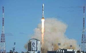
Vostochny cosmodrome
In July 2010, Prime Minister Vladimir Putin announced that the area would be the site of a new Vostochny Cosmodrome ("Eastern Spaceport"), to reduce Russian dependence on the Baikonur Cosmodrome in Kazakhstan.[26] In May, 2016 there was the first rocket launch.
Sister province
References
| Wikivoyage has a travel guide for Amur Oblast. |
| Wikimedia Commons has media related to Amur Oblast. |
Notes
- ↑ Article 3 of the Charter of Amur Oblast does not specify any symbols of the oblast other than the flag and the coat of arms
- ↑ Президент Российской Федерации. Указ №849 от 13 мая 2000 г. «О полномочном представителе Президента Российской Федерации в федеральном округе». Вступил в силу 13 мая 2000 г. Опубликован: "Собрание законодательства РФ", №20, ст. 2112, 15 мая 2000 г. (President of the Russian Federation. Decree #849 of May 13, 2000 On the Plenipotentiary Representative of the President of the Russian Federation in a Federal District. Effective as of May 13, 2000.).
- ↑ Госстандарт Российской Федерации. №ОК 024-95 27 декабря 1995 г. «Общероссийский классификатор экономических регионов. 2. Экономические районы», в ред. Изменения №5/2001 ОКЭР. (Gosstandart of the Russian Federation. #OK 024-95 December 27, 1995 Russian Classification of Economic Regions. 2. Economic Regions, as amended by the Amendment #5/2001 OKER. ).
- ↑ USSR. Administrative-Territorial Divisions of the Union Republics, p. 99
- 1 2 Charter of Amur Oblast, Article 10
- ↑ Official website of Amur Oblast. Alexander Alexandrovich Kozlov Archived July 8, 2015, at the Wayback Machine. (Russian)
- ↑ Федеральная служба государственной статистики (Federal State Statistics Service) (2004-05-21). "Территория, число районов, населённых пунктов и сельских администраций по субъектам Российской Федерации (Territory, Number of Districts, Inhabited Localities, and Rural Administration by Federal Subjects of the Russian Federation)". Всероссийская перепись населения 2002 года (All-Russia Population Census of 2002) (in Russian). Federal State Statistics Service. Retrieved 2011-11-01.
- 1 2 3 4 5 Russian Federal State Statistics Service (2011). "Всероссийская перепись населения 2010 года. Том 1" [2010 All-Russian Population Census, vol. 1]. Всероссийская перепись населения 2010 года (2010 All-Russia Population Census) (in Russian). Federal State Statistics Service. Retrieved June 29, 2012.
- ↑ The density value was calculated by dividing the population reported by the 2010 Census by the area shown in the "Area" field. Please note that this value may not be accurate as the area specified in the infobox is not necessarily reported for the same year as the population.
- ↑ Amur Oblast Territorial Branch of the Federal State Statistics Service. Возрастно-половой состав населения на 1 января 2014 года (Russian)
- ↑ Правительство Российской Федерации. Федеральный закон №107-ФЗ от 3 июня 2011 г. «Об исчислении времени», в ред. Федерального закона №271-ФЗ от 03 июля 2016 г. «О внесении изменений в Федеральный закон "Об исчислении времени"». Вступил в силу по истечении шестидесяти дней после дня официального опубликования (6 августа 2011 г.). Опубликован: "Российская газета", №120, 6 июня 2011 г. (Government of the Russian Federation. Federal Law #107-FZ of June 31, 2011 On Calculating Time, as amended by the Federal Law #271-FZ of July 03, 2016 On Amending Federal Law "On Calculating Time". Effective as of after sixty days following the day of the official publication.).
- ↑ Official on the whole territory of Russia according to Article 68.1 of the Constitution of Russia.
- 1 2 3 4 5 6 7 8 "Amur Region". Russia: All Regions Trade & Investment Guide (PDF). CTEC Publishing LLC. 2008. Archived from the original (PDF) on July 15, 2011.
- ↑ "Amur Region". Kommersant.com. Retrieved 2013-08-21.
- ↑ Russian Federal State Statistics Service (May 21, 2004). "Численность населения России, субъектов Российской Федерации в составе федеральных округов, районов, городских поселений, сельских населённых пунктов – районных центров и сельских населённых пунктов с населением 3 тысячи и более человек" [Population of Russia, Its Federal Districts, Federal Subjects, Districts, Urban Localities, Rural Localities—Administrative Centers, and Rural Localities with Population of Over 3,000] (XLS). Всероссийская перепись населения 2002 года [All-Russia Population Census of 2002] (in Russian). Retrieved August 9, 2014.
- ↑ Demoscope Weekly (1989). "Всесоюзная перепись населения 1989 г. Численность наличного населения союзных и автономных республик, автономных областей и округов, краёв, областей, районов, городских поселений и сёл-райцентров" [All Union Population Census of 1989: Present Population of Union and Autonomous Republics, Autonomous Oblasts and Okrugs, Krais, Oblasts, Districts, Urban Settlements, and Villages Serving as District Administrative Centers]. Всесоюзная перепись населения 1989 года [All-Union Population Census of 1989] (in Russian). Институт демографии Национального исследовательского университета: Высшая школа экономики [Institute of Demography at the National Research University: Higher School of Economics]. Retrieved August 9, 2014.
- ↑ "Перепись-2010: русских становится больше". Perepis-2010.ru. 2011-12-19. Retrieved 2013-08-21.
- ↑
- ↑ "Естественное движение населения в разрезе субъектов Российской Федерации". Gks.ru. Retrieved 2013-08-21.
- ↑ http://amurstat.gks.ru/wps/wcm/connect/rosstat_ts/amurstat/resources/fa6eca8041bc1e41ba5efe2d59c15b71/07_1_9.htm
- 1 2 3 Arena - Atlas of Religions and Nationalities in Russia. Sreda.org
- ↑ 2012 Survey Maps. "Ogonek", № 34 (5243), 27/08/2012. Retrieved September 24, 2012.
- ↑ Валовой региональный продукт на душу населения Федеральная служба государственной статистики
- ↑ Shandala N, Filonova A, Titov A, Isaev D, Seregin V, Semenova V, and Metlyaev EG (2009), Radiation situation nearby the uranium mining facility, 54th Annual Meeting of the Health Physics Society, 12–16 July 2009, Minneapolis, MN, USA.
- ↑ [China and Russia to build world’s biggest thermal power plant http://rt.com/business/china-russia-thermal-plant-671/]
- ↑ Moskvitch, Katia (July 20, 2010). "BBC News - Russia to kick off construction of a new spaceport". Bbc.co.uk. Retrieved August 21, 2013.
Sources
- Амурское областное Собрание. №40-ОЗ 13 декабря 1995 г. «Устав (Основной Закон) Амурской области», в ред. Закона №384-ОЗ от 7 июля 2014 г. «О внесении изменений в Устав (Основной Закон) Амурской области». Вступил в силу через десять дней после официального опубликования. Опубликован: "Амурская правда", №295–296, 20 декабря 1995 г. (Amur Oblast Assembly. #40-OZ December 13, 1995 Charter (Basic Law) of Amur Oblast, as amended by the Law #384-OZ of July 7, 2014 On Amending the Charter (Basic Law) of Amur Oblast. Effective as of the day which is ten days after the official publication.).
- Дударев, В. А.; Евсеева, Н. А. (1987). И. Каманина, ed. СССР. Административно-территориальное деление союзных республик (in Russian). Moscow.
- Губернатор Амурской области. Постановление №607 от 25 октября 2005 г. «О совершенствовании системы информационного обеспечения органов государственной власти и местного самоуправления области». (Governor of Amur Oblast. Resolution #607 of October 25, 2005 On Improving the Information System Serving the Organs of the State Power and the Local-Self Government of the Oblast. ).
- Information concerning the Shiwei tribes and their relationship with the Khitans
- (Russian) History of Amur Oblast
| |||||||||||||||||||||||||||||||
| |||||||||||||||||||||||||||||||
 |
|
|
|
|
| |
|
| ||
| ||||
| | ||||
| Heilongjiang, |
Heilongjiang, |
|