Presswood, California
| Presswood | |
|---|---|
| Unincorporated community | |
 Presswood  Presswood Location in California | |
| Coordinates: 39°10′06″N 123°12′21″W / 39.16833°N 123.20583°WCoordinates: 39°10′06″N 123°12′21″W / 39.16833°N 123.20583°W | |
| Country | United States |
| State | California |
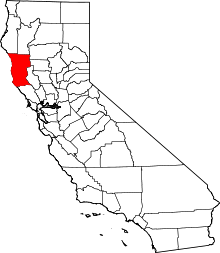
| County | Mendocino County |
| Elevation[1] | 620 ft (189 m) |
Presswood is an unincorporated community in Mendocino County, California.[1] It is located on the Northwestern Pacific Railroad 1.25 miles (2 km) north of Ukiah,[2] at an elevation of 620 feet (189 m).[1] The community name recognized the product of a large Masonite factory built in 1948 to use the Ukiah labor force and the railroad shipping facilities. The factory closed in 2001 and was subsequently razed.[3]
Climate
This region experiences warm (but not hot) and dry summers, with no average monthly temperatures above 71.6 °F. According to the Köppen Climate Classification system, Presswood has a warm-summer Mediterranean climate, abbreviated "Csb" on climate maps.[4]
References
- 1 2 3 U.S. Geological Survey Geographic Names Information System: Presswood, California
- ↑ Durham, David L. (1998). California's Geographic Names: A Gazetteer of Historic and Modern Names of the State. Clovis, Calif.: Word Dancer Press. p. 126. ISBN 1-884995-14-4.
- ↑ Tsai, Peijean. "Ukiah's lost economy -- Closure of Masonite, other manufacturers has left a hole". Mendocino Redwood Company. Retrieved 15 September 2014.
- ↑ Climate Summary for Presswood, California
This article is issued from Wikipedia - version of the 7/5/2016. The text is available under the Creative Commons Attribution/Share Alike but additional terms may apply for the media files.