Poverty Point
| Poverty Point National Monument | |
|---|---|
|
IUCN category V (protected landscape/seascape) | |
|
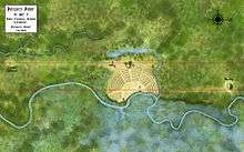
A map of the Poverty Point site | |
 | |
| Location | West Carroll Parish, Louisiana, U.S. |
| Nearest city | Epps, Louisiana |
| Coordinates | 32°38′12″N 91°24′41″W / 32.63667°N 91.41139°WCoordinates: 32°38′12″N 91°24′41″W / 32.63667°N 91.41139°W |
| Area | 910.85 acres (368.61 ha)[1] |
| Authorized | October 31, 1988 |
| Governing body |
State of Louisiana National Park Service |
| Website | Poverty Point National Monument |
| Official name | Monumental Earthworks of Poverty Point |
| Type | Cultural |
| Criteria | iii |
| Designated | 2014 (38th session) |
| Reference no. | 1435 |
| State Party | United States |
| Region | Europe and North America |
.png)
Poverty Point (French: Pointe de Pauvreté) (16 WC 5) is a prehistoric earthworks of the Poverty Point culture, now a U.S. National Monument and World Heritage Site[2] located in the Southern United States. It is 15.5 miles (24.9 km) from the current Mississippi River,[3] and situated on the edge of Maçon Ridge, near the village of Epps in West Carroll Parish in northeastern Louisiana.
Poverty Point comprises several earthworks and mounds built between 1650 and 700 BC, during the Archaic period in the Americas by a group of Native Americans of the Poverty Point culture. The culture extended 100 miles (160 km) across the Mississippi Delta. The original purposes of Poverty Point have not been determined by archaeologists, although they have proposed various possibilities including that it was: a settlement, a trading center, and/or a ceremonial religious complex.
The 910-acre (1.42 sq mi; 3.68 km2) site, which has been described as "the largest and most complex Late Archaic earthwork occupation and ceremonial site yet found in North America"[4] is a registered National Monument. The monument was brought to the attention of archaeologists in the early 20th century, when it was given the name of Poverty Point after a nearby plantation. Since then, various excavations have taken place at the site. Scholars have advanced various theories regarding the purpose of the mound site, including religious and ceremonial. Other writers have proposed pseudo-archaeological and New Age associations. The complex attracts many tourists as a destination.
Site description
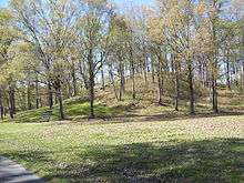
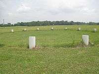
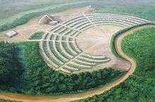
Poverty Point is constructed entirely of earthworks. The core of the site measures approximately 500 acres (2.0 km2), although archaeological investigations have shown that the total occupation area extended for more than three miles (5 km) along the river terrace.[5] The monumental construction is a group of six concentric, crescent ridge earthworks, divided by five aisles radiating from the center at the river bank. The site also has several mounds both on the outside and inside of the ring earthworks. The name "Poverty Point" came from the plantation which once surrounded the site.
UNESCO World Heritage Site designation
In January 2013, the United States Department of the Interior nominated Poverty Point for inclusion on the UNESCO World Heritage List. State Senator Francis C. Thompson of Delhi in Richland Parish said the matter is not "just a local or even state issue [but] of international importance. The prestige of having a World Heritage Site in our region and state would be of great significance both culturally and economically."[6]
On June 22, 2014, UNESCO approved Poverty Point as a World Heritage Site at its convention in Doha, Qatar, announced Lieutenant Governor Jay Dardenne, who sent a two-person delegation to the Middle East to urge the inclusion of Poverty Point alongside such cultural landmarks as Stonehenge in England, the Pyramid Fields at Giza in Egypt and the Great Wall of China. The designation makes Poverty Point the first World Heritage Site in Louisiana and only the 22nd in the United States.[2]
Six curving earthworks
The main part of the monument is the six concentric curving earthworks located in the center of the site. Each is separated from one another by a flat corridor of earth. Dividing the ridges into three sections (formerly five) are two ramps that slope inwardly, leading to Bayou Maçon. Each of the ridge earthworks is about three feet high.[3] Archaeologists believe they were once five feet high,[7] but have been worn down through agricultural ploughing over the last few centuries. The approximate diameter of the outside ridge is three-quarters of a mile, while the innermost ridge’s diameter is about three-eighths of a mile.[3][8]
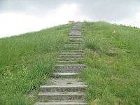
Mound A (The Bird Mound)
Alongside these ridges are other earthworks, primarily platform mounds. The largest of these, Mound A, is to the west of the ridges, and is roughly T-shaped when viewed from above. Many have interpreted it as being in the shape of a bird and also as an "Earth island", representing the cosmological center of the site.[5]
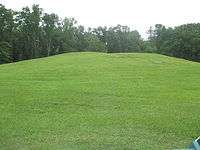
Researchers have learned that Mound A was constructed quickly, probably over a period of less than three months.[5] Prior to construction, the vegetation covering the site was burned. According to radiocarbon analysis, this burning occurred between approximately 1450 and 1250 BCE. Workers immediately covered the area with a cap of silt, followed quickly by the main construction effort. There are no signs of construction phases or weathering of the mound fill even at microscopic levels, indicating that construction proceeded in a single massive effort over a short period.[5] In total volume, Mound A is made up of approximately 238,000 cubic meters of fill, making it the second-largest earthen mound (by volume) in eastern North America. It is second in overall size to the later Mississippian-culture Monks Mound at Cahokia, built beginning about 950-1000 CE in present-day Illinois.[5]
Mounds A, B and E lie on a north-south line.[9]
A low-elevation barrow pit, which sometimes carries running water, is located between Mounds A and B. Presumably the Poverty Point people carried dirt from this area to build the mounds.[10]
Mound B
Mound B, a platform mound, is located north and west of the rings. Below the mound was found a human bone interred with ashes, a likely indication of cremation, suggesting that this might have been a burial mound, or the individual may have been a victim of human sacrifice.[11]
Past Mound B is the "Nature Watch", where visitors have observed local animals, including foxes, snakes, white-tailed deer, armadillos, raccoon, and squirrels. An occasional black bear has been spotted here too.[12]
Past the Nature Watch are the "Northwestern Ridges", a wave-like appearance of ridged embankments, some two or three feet in height. North America's only native bamboo, Arundinaria gigantea. or switch cane from this area, grew in thick stands known as canebrakes, and were used by early peoples to make baskets and arrowshafts.[13]
Mound C
Mound C is the only one inside the plaza area of the historic site. It is 6.5 feet tall. The depression that divides the mound was caused by a 19th-century wagon road which proceeded northward to the old town of Floyd, Louisiana. The mound is believed to have been constructed ca. 1550 BCE in sixteen stages of development. The sixteenth level gave the mound its final dome shape.[14]
Mound E (Ballcourt Mound)
The Ballcourt Mound, which is also a platform mound, is so called because "two shallow depressions on its flattened top reminded some archaeologists of playing areas in front of outdoor basketball goals, not because they had any revelation about Poverty Point's sports scene."[15]
Dunbar and Lower Jackson mounds
Within the enclosure created by the curving earthworks, two additional platform mounds were located. The Dunbar Mound had various pieces of chipped precious stones upon it, indicating that people used to sit atop it and make jewelry.[16] South of the site center is the Lower Jackson Mound, which is believed to be the oldest of all the earthworks at the site.[3] In the southern edge of the site, the Motley Mound rises 51 ft (16 m). The conical mound is circular and reaches a height of 24.5 ft (7.5 m). These three platform mounds are much smaller than the other mounds.
History
Construction
Poverty Point was not constructed all at once, but appears to have been built up over a period of centuries or even millennia, as additions were made by successive generations. Excavations in 2009 by the University of Louisiana at Monroe and Mississippi State University have revealed evidence that wooden-post circular structures 80 to 160 feet (49 m) wide had been built in the plaza area; whether these features were contemporary with other constructions at the site is not currently known.
The first part of the surviving monument that was built was the Lower Jackson Mound, which was probably constructed during the Middle Archaic period. It has several highly typical features of Middle Archaic mounds, such as baked loess blocks and Evans points. It may have been built hundreds or even thousands of years before construction of the rest of Poverty Point.[17] Some archaeologists believe that Ballcourt Mound may also have been built around this time, though this remains unproven.[9]
The rest of the monument was built later, during the Later Archaic period. Its creators intentionally incorporated the older monuments of the Lower Jackson Mound and the Ballcourt Mound into it. Exactly when construction of the rest of the earthworks commenced, and for how long that construction continued, has remained a matter of speculation and debate. Radiocarbon dating of the site has produced a wide variety of results, and suggested that most of the rings had been constructed between 1600 and 1300 BCE.[18] A synthesis of radiocarbon dates from the site suggests earthwork construction began as early as 1800 BCE and continued until as late as 1200 BCE.[19] This indicates that the monument had likely been gradually built over several centuries by groups of successive generations.
Although the time scale regarding the building of Poverty Point is still somewhat uncertain, archaeological evidence has shown more clearly how the earthworks were constructed. The number of workers involved is unknown, although the archeologist Jon L. Gibson has estimated that it could have been produced in a century by three generations: if a hundred people had spent six or seven days a month on its construction.[20] Evidence shows that the workers probably lived on-site during construction, setting up temporary homes on top of the very earthworks that they were building, moving them whenever that particular earthwork was added to.[21] Prior to the construction of the earthworks, workers leveled the land around the site and filled in ditches, as has been found by archaeological investigation.They constructed the grand, flat plaza on the site.[22] The main building material was loess, a type of soil which is easy to dig but has the problem of quickly turning to mud when exposed to water. For this reason clay was used to pack around the loess in order to protect it from rain and ensure that the monuments did not wash away.[23]
Purposes
Archaeologists have debated the functions of the Poverty Point site since its rediscovery. One of the main questions has been whether it was used for a settlement, or only for periodic ceremonial events. Archaeologists including Jon L. Gibson have postulated that houses were constructed on top of the concentric ring earthworks. A few postholes have been found upon these earthworks, indicating the former presence of a building. Other archaeologists believe that regular residence would have produced more postholes as an archaeological feature. Gibson and others note these could have been destroyed by the subsequent plowing that took place on much of the site.[24]
Archaeologists such as Sherwood Gagliano and Edwin Jackson support the concept that Poverty Point was a site where various groups came to meet and trade on an occasional basis. Gibson believes there was evidence of too much rubbish left by original inhabitants to indicate only occasional habitation, and that it would be implausible for such a monument to be built to be used simply as a trading center.[25]
Some archaeologists have interpreted Poverty Point as having religious symbolism and importance. A posthole discovered in the central plaza showed that a large post was possibly erected there. The archaeologist Professor William Haag, who excavated at the site during the 1970s, interpreted this post as having astronomical significance in being aligned to the solstices. Examples of wooden post astronomical circles, since called Woodhenge, have been found and reconstructed at the Mississippian culture site of Cahokia in western Illinois. However, the astronomer Robert Purrington believes the posts at Poverty Point were geometrically, rather than astronomically, aligned.[26] Researchers have also studied historic and contemporary Native American religious beliefs for parallels, with many noting that the west is seen as the direction of evil and death. Gibson believed that the rings were built with their arcs against the west to keep malevolent spirits out of the complex.[27]
Poverty Point People
The Poverty Point culture people who constructed Poverty Point were hunter-gatherers rather than agriculturalists. They are a rare example of a complex hunter-gatherer society that constructed large scale monuments. The vast majority of other prehistoric monuments, ranging from Stonehenge in England to Khufu's Great Pyramid at Giza in Egypt, were constructed by agricultural societies, in which crop surpluses allowed greater density of population and stratification of society. Another exception to this general rule is the Göbekli Tepe complex in southern Anatolia (Turkey), also built by hunter-gatherers, which dates from around 10,000 BCE.
The food sources of the people at Poverty Point came from the local animals and plant life in the region. They cooked food in hearths and pits that likely acted as earth ovens, some of which had plastered walls.[28] Firewood was chosen carefully, with specific trees being used, namely oak and to a lesser degree hickory and cane, which archaeologist Jon L. Gibson believed was due to the fact that oak and hickory add a specific savoury flavour to food.[29]
Changes in temperature and precipitation, such as increased flooding, caused an ecological imbalance that led to abandonment of Poverty Point. Archeologists use this as a time boundary between the Archaic and later Woodland periods.[30]
Artifacts
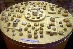
The vast majority of artifacts uncovered at Poverty Point are small, baked shapes made of loess, which are usually balls, bicones or ropes, all of which have been described as “Poverty Point Objects” or PPOs. Archaeologists have long debated their uses. They have concluded the fired earth objects were used in cooking, a conclusion reached through experimental archaeology. When placed in earth ovens, the objects were shown to hold heat and aid in cooking food.[31] Stone boiling was an alternate way of heating up food before pottery could withstand the heat. The soil of the lower Mississippian Valley located at Poverty Point does not contain proper pebbles, manufacturing of artificial stones was therefore necessary.[30]
The inhabitants of Poverty Point produced small amounts of pottery, creating a variety of different kinds: fiber-tempered, sand-tempered, clay grit-tempered and untempered. They used both the Wheeler and Old Floyd Tchefuncte design styles as decoration.[32] More commonly, however, they used stone vessels, some of which were made on-site and which would have taken greater effort than the production of pottery.[33]
Many of their tools appear to have been made on-site, as there is evidence of debris from their construction process found across much of Poverty Point.[34] However, they were also active in trade with other Native American peoples. A disproportional amount of imported items, consisting of projectile points and microliths, have been determined to have originated in the Ouachita and Ozark Mountains and in the Ohio and Tennessee River valleys.[7] Other materials derived from trade are soapstone from the southern Appalachian Mountains of Alabama and Georgia,[7] and copper and galena artifacts, indicating trade with the prehistoric copper-producing tribes in the upper Great Lakes region.[3]
Discovery, excavation and tourism

Discovery and archaeological excavation
The first evidence for a later human encountering ancient Poverty Point comes from a burial of a twelfth-century CE Caddo Native American. His grave was excavated at the Mounds Plantation, a village on the Red River in north-western Louisiana, approximately 150 miles (240 km) to the west of this monument. This individual, whom some scholars have speculated was a konah, or medicine man, was buried with various charms within his medicine bundle; these included artifacts from Poverty Point, such as two red stone beads, a slate pendant and a hematite plummet.[35] It appears he had come across the site, or encountered someone else who did, and had ancient artifacts taken from it, perhaps believing they had a spiritual reference or power and could be used as amulets.
In the 1830s Jacob Walter, a man searching for lead ore in the area, came across Poverty Point and wrote about it in his diary.[36] The first published account of the site was in 1873 by Samuel Lockett, who had served as an officer in the Confederate Army during the American Civil War.[35]
During the early 20th century, archaeologists took interest in the site, with it being briefly investigated by Clarence B. Moore over 1911–1912, by Gerard Fowke of the Smithsonian Institution in 1926, by Clarence H. Webb in 1935, and by Michael Beckman in 1946, while he was searching for oil.[37] Three excavation seasons in 1952, 1953 and 1954 were undertaken by James A. Ford and Robert Neitzel, leading to the publication of Poverty Point, a Late Archaic Site in Louisiana in 1956.[38] It was during this excavation that "Poverty Point witnessed some of the first experimental archaeology done in North America."[39]
Excavations have continued at the site into the 21st century, as researchers have tried to learn more about the nature of the site and its culture. At one time scholars thought the Poverty Point culture had developed North America's first chiefdom, but this theory has been discredited.[40]
Public access
In 1960, John Griffin, who at the time was the Southeast Regional Archaeologist for the National Park Service, suggested to the Federal government that Poverty Point be declared and established as a National Monument. He described the site: "Poverty Point is the largest and most complex Late Archaic earthwork occupation and ceremonial site yet found in North America".[4] At first the United States Congress declined to support the protection, fearing the unpopularity of acquiring the land from local landowners,[41] but the site was designated as a National Historic Landmark on June 13, 1962.
In 1972, the State of Louisiana purchased a 400-acre (1.6 km2) section of the site. In 1975, the state opened the land to the public as the Poverty Point Commemorative Area. The state built a museum devoted to interpreting the monument and the artifacts uncovered there.[42] In 1988 Congress designated the site as a U.S. National Monument.[43] It has become a popular tourist destination.[41]
Today Poverty Point National Monument is open for visitors daily from 9 a.m. to 5 p.m. except for Thanksgiving, Christmas Day, and New Year's Day. The cost of the entrance is $4 per person; those over the age of 62 and children 12 and under are admitted without charge.[7] As the site is managed by the Louisiana State Parks System, a National Parks pass is not accepted for admission. The site is occasionally monitored by the National Historic Landmark program, which is concerned about the erosion of the mounds. Louisiana is working with the Vicksburg U.S. Army Corps of Engineers division in developing plans for erosion control.[4]
Erosion
In 2013, Lieutenant Governor Jay Dardenne, the ex officio head of the Louisiana Department of Culture, Recreation and Tourism, requested $750,000 in emergency state funding to limit erosion at Poverty Point, a candidate for World Heritage Site by UNESCO. The request was made to the Interim Emergency Board, which considers projects that arise when the legislature is not in session. Dardenne asked the emergency board to expedite funding in advance of the beginning of the legislative session on April 8. An alternative funding plan would be for Governor Bobby Jindal to include the emergency funds in regular 2013 appropriations. The erosion which threatens the prehistoric earthworks is caused by Harlin Bayou in the northern part of the site.[44]
See also
- Mound builder (people)
- Toltec Mounds Archeological State Park
- Watson Brake
- List of National Historic Landmarks in Louisiana
- National Register of Historic Places listings in West Carroll Parish, Louisiana
Notes
- ↑ "Listing of acreage as of December 31, 2011". Land Resource Division, National Park Service. Retrieved 2012-05-14.
- 1 2 Greg Hilburn. "A first for Louisiana: Poverty Point selected as World Heritage site". Monroe News-Star. Retrieved June 23, 2014.
- 1 2 3 4 5 Milner 44-50
- 1 2 3 "Poverty Point", National Historic Landmarks Program, National Park Service
- 1 2 3 4 5 Kidder, Tristram R.; Ortmann, Anthony L.; Arco, Lee J. (November 2008), "Poverty Point and the Archaeology of Singularity", Society for American Archaeology Archaeological Record, 8 (5): 9–12
- ↑ Greg Hilburn. "Geopolitics threaten Poverty Point's fate: US in arrears to UNESCO, which decides World Heritage Sites, July 16, 2013". The Monroe News-Star. Retrieved July 17, 2013.
- 1 2 3 4 Louisiana – Department of Culture, Recreation & Tourism
- ↑ Gibson (2000:80)
- 1 2 Gibson (2000:98-99)
- ↑ Driving Guide, Poverty Point State Historic Site, Epps, Louisiana, p. 4
- ↑ Gibson (2000:86-87)
- ↑ Driving Guide, p. 7
- ↑ Driving Guide, p. 8
- ↑ Driving Tour, p. 9
- ↑ Gibson (2000:85)
- ↑ Gibson (2000:88-89)
- ↑ Gibson (2000:91)
- ↑ Gibson (2000:94-95)
- ↑ Connolly, Robert P. An Assessment of Radiocarbon Age Results from the Poverty Point Site. 2006. Louisiana Archaeology, Volume 28, pp. 1-14.
- ↑ Gibson (2000::109)
- ↑ Gibson (2000:103-105)
- ↑ Gibson (2000:96-97)
- ↑ Gibson (2000:91-92)
- ↑ Gibson (2000:100-103)
- ↑ Gibson (2000:106-108)
- ↑ Gibson (2000:30)
- ↑ Gibson (2000:108-109)
- ↑ Gibson (2000:125)
- ↑ Gibson (2000:127)
- 1 2 Snow, Dean R. (2010). Archaeology of Native North America. New York: Prentice Hall. p. 95.
- ↑ Gibson (2000:112-116)
- ↑ Gibson (2000:116-117)
- ↑ Gibson (2000:121-)
- ↑ Gibson (2000:112)
- 1 2 Gibson (2000:16)
- ↑ Gibson (2000:15-16)
- ↑ Gibson (2000:16-17)
- ↑ Gibson (2000:20-21)
- ↑ Gibson (2000:23)
- ↑ Gibson (2000:26-27)
- 1 2 Gibson (2000:5)
- ↑ Gibson (2000:4)
- ↑ "The National Parks: Index 2009–2011". National Park Service.
- ↑ "Marsha Shuler, "Poverty Point erosion funds sought", March 28, 2013". Baton Rouge Morning Advocate. Retrieved March 29, 2013.
References
- nps.gov
- crt.state.la
- met.museum
- Gibson, Jon L. (2000). The Ancient Mounds of Poverty Point: Place of Rings. Gainesville, Florida: University Press of Florida.
- Milner, George R. (2004). The Moundbuilders: Ancient Peoples of Eastern North America. London: Thames & Hudson Ltd.
External links
- National Park Service: official Poverty Point National Monument website
- State of Louisiana: Poverty Point State Historic Site
- Louisiana Archaeological Survey — "Poverty Point"
- The Archaeology Channel.org: "Poverty Point Earthworks"
- Romain, William F.; Davis, Norman L. (2013). "Astronomy and Geometry at Poverty Point". Louisiana Archaeological Society.
| Wikimedia Commons has media related to Poverty Point. |
| Topics | |
|---|---|
| Lists by states |
|
| Lists by insular areas | |
| Lists by associated states | |
| Other areas | |
| |