Potholes Reservoir
| Potholes Reservoir | |
|---|---|
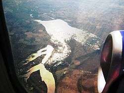 Aerial view from the north (2009). Moses Lake is at lower left and the Potholes Reservoir at center. | |
| Location |
Grant County, Washington, United States |
| Coordinates | 46°58′57″N 119°17′28″W / 46.98250°N 119.29111°WCoordinates: 46°58′57″N 119°17′28″W / 46.98250°N 119.29111°W[1] |
| Lake type | Reservoir |
| Basin countries | United States |
| Surface elevation | 1,043 feet (318 m)[1] |
| References | [1] |
The Potholes Reservoir is part of the Columbia Basin Irrigation Project. It is formed by the O'Sullivan Dam and located in central Washington, in the United States. The reservoir is fed by water from Moses Lake, part of the Crab Creek basin.
The area features several lakes (typically 30-70 yards wide and 10–30 feet deep). These lakes, known as "potholes" were created through both natural and man made processes. The potholes were initially carved out during the Pleistocene by flood waters originating from Glacial Lake Missoula.[2] Subsequent damming of the area by the Columbia Basin Project raised the water table high enough to allow these topographical depressions to become lakes.
Also known as:[1]
- Moses Lake
- O'Sullivan Reservoir
- Mardon
- Mardon Resort
Recreation
On the shore of the reservoir is Potholes State Park, a 640-acre (2.6 km2) member of the Washington State Park System. It has 600 feet (180 m) of shoreline on the reservoir.[3]
Fishing
There are many types of fish inside of the reservoir, including:
- Largemouth Bass
- Smallmouth Bass
- Rainbow Trout
- Walleye
- Black Crappie
- Yellow Perch
- Bluegill
- Lake Whitefish
- Carp
References
- 1 2 3 4 "Potholes Reservoir". Geographic Names Information System. United States Geological Survey. Retrieved 2009-05-03.
- ↑ Alt, David; Hundman, Donald W. (1995). Northwest Exposures: A Geologic History of the Northwest. Missoula, Mont.: Mountain Press. ISBN 0-87842-323-0. OL 800810M.
- ↑ "Potholes State Park". Washington State Parks and Recreation Commission. Retrieved February 5, 2015.
External links
- Potholes Reservoir Unit Washington Department of Fish and Wildlife
- Potholes Reservoir Resource Management Plan U.S. Department of the Interior
- Potholes Reservoir Fishing Washington Department of Fish and Wildlife