Posillipo
Posillipo is a residential quarter of Naples, southern Italy, located along the northern coast of the Gulf of Naples; it is called Pusilleco in the Neapolitan language.
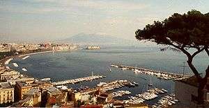
Geography
The houses at water's edge all have at least small piers or landings, and there are even a few small coves with breakwaters along the way. These small harbors are the nuclei for separate, named communities such as Gaiola and Marechiaro, with the characteristic "Large rock".
History

The French Homeric scholar Victor Bérard[1] identified Posillipo as the land of Homer's Cyclopes.
It is mentioned in ancient Greek and Roman sources. The Greeks first named this rocky, wooded height at the western end of the Bay of Naples Pausílypon, meaning "respite from worry". There are Roman ruins at waters edge and just before the cape at the end of the Bay of Naples, one can even see the openings of the air-shafts that ventilated the tunnel that led to the residence of Vedius Pollio. Those premises are partially intact upon the cliff, and include an amphitheater on a height.
The area remained largely undeveloped until a road, via Posillipo, was built between 1812-24. That road starts at sea-level at the Mergellina harbor and moves up the coast, roughly parallel to the shore. The School of Posillipo was started by Anton Sminck Pitloo painting marine shore landscapes from this area.
The area has been heavily overbuilt since the end of World War II, but contains some notable historical buildings and landmarks. Among these is the Villa Rosebery, the Italian President's residence during his stays in Naples. It also contains a Mausoleum to those who died for their country, the Mausoleo Schilizzi.
Sports
Posillipo has given its name to Naples' waterpolo team, Circolo Nautico Posillipo. The neighborhood was seat of the homonym circuit which hosted the Grand Prix of Naples between 1933 and 1962.
Famous residents
- George Norman Douglas (1868-1952) Scottish-Austrian travel and novel writer. In 1897 lived in Villa Maya, Posillipo Naples, Italy.
- Oscar Wilde completed "The Ballad of Reading Gaol" while residing in Posillipo in 1897.[2]
- Posillipo is the birthplace of Franco Alfano, the Italian composer and pianist best known for completing Turandot.
- Sándor Márai, the author of Embers, lived in Posillipo between 1948 and 1952; his novel "San Gennaro vére" ("Blood of San Gennaro") is set in Naples.
- It may well also have been the residence of Virgil, the Roman poet of, most famously, the 'Aeneid'.
- Franco Ambrosio, the wheat magnate and Formula One racing team sponsor, lived in Posillipo until his death in 2009.
- Giambattista Basile was born in Posillipo in 1575. It is also the setting of one of his first works Le Avventurose Disavventure (The Adventurous Misadventures) published in 1611.
References
- ↑ (Bérard 1927-9); (Bérard 1933)
- ↑ Hazzard, Shirley (2008). Ancient Shore. University of Chicago Press. p. 32.
External links
Coordinates: 40°48′20″N 14°12′12″E / 40.80556°N 14.20333°E