Portsmouth International Airport at Pease
| Portsmouth International Airport at Pease | |||||||||||
|---|---|---|---|---|---|---|---|---|---|---|---|
|
| |||||||||||
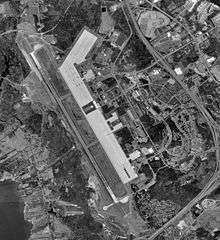 USGS 1998 orthophoto | |||||||||||
| IATA: PSM – ICAO: KPSM – FAA LID: PSM | |||||||||||
| Summary | |||||||||||
| Airport type | Public / Military | ||||||||||
| Owner | Pease Development Authority | ||||||||||
| Serves | Portsmouth, New Hampshire | ||||||||||
| Location | Portsmouth / Newington, New Hampshire, USA | ||||||||||
| Elevation AMSL | 100 ft / 30 m | ||||||||||
| Coordinates | 43°04′41″N 070°49′24″W / 43.07806°N 70.82333°WCoordinates: 43°04′41″N 070°49′24″W / 43.07806°N 70.82333°W | ||||||||||
| Website |
FlyPortsmouthAirport | ||||||||||
| Map | |||||||||||
 PSM  PSM Location of airport in New Hampshire/United States | |||||||||||
| Runways | |||||||||||
| |||||||||||
| Statistics (2007) | |||||||||||
| |||||||||||
Portsmouth International Airport at Pease[1][2] (IATA: PSM, ICAO: KPSM, FAA LID: PSM), formerly known as Pease International Airport, is a joint civil and military use airport located one nautical mile (2 km) west of the central business district of Portsmouth, a city in Rockingham County, New Hampshire, United States. It is owned by the Pease Development Authority.[2] It is included in the Federal Aviation Administration (FAA) National Plan of Integrated Airport Systems for 2017–2021, in which it is categorized as a non-hub primary commercial service facility.[3]
The airport is located within the Pease International Tradeport,[4] a result of the ongoing redevelopment of the former Pease Air Force Base which was closed under Base Realignment and Closure (BRAC) Commission action in the late 1980s and early 1990s.
It shares the runway with the Pease Air National Guard Base, which is actively utilized by the 157th Air Refueling Wing (157 ARW) of the New Hampshire Air National Guard, an Air Mobility Command (AMC)-gained Air National Guard unit operating the KC-135R Stratotanker aircraft and slated to receive the KC-46A Pegasus aircraft.[5] The 64th Air Refueling Squadron (64 ARS), an active duty USAF unit of the 22nd Air Refueling Wing (22 ARW) at McConnell AFB, is also embedded and located with the 157 ARW at Pease ANGB.
Pease was one of 7 Launch Abort Sites and one of 18 Emergency Landing Sites for NASA space shuttle orbiters.[6]
The airport served as a hub for Pan Am from 1998 until 2005, when all mainline Pan Am flights at the airport were suspended. It was also one of a handful of airports served by the short-lived Skybus Airlines, which ceased operation in the spring of 2008. Commercial airline service resumed with Allegiant Air starting on October 25, 2013.
Facilities and aircraft
.jpg)
Portsmouth International Airport at Pease covers an area of 3,000 acres (1,200 ha) at an elevation of 100 feet (30 m) above mean sea level. It has one concrete and asphalt paved runway designated 16/34 which measures 11,321 by 150 feet (3,451 x 46 m).[2]
For the 12-month period ending October 1, 2007, the airport had 51,673 aircraft operations, an average of 141 per day: 68% general aviation, 22% military, 7% air taxi and 3% scheduled commercial. At that time there were 107 aircraft based at this airport: 52% single-engine, 19% multi-engine, 12% jet, 2% helicopter and 15% military.[2]
Portsmouth International Airport at Pease is the current base for PlaneSense, a company that offers fractional aircraft ownership programs.[7] Additionally, the airport's taxiways and runways are shared with Pease Air National Guard Base.
Airlines and destinations
| Airlines | Destinations |
|---|---|
| Allegiant Air[8] | Fort Lauderdale, Orlando/Sanford, Punta Gorda/Fort Myers Seasonal: St. Petersburg/Clearwater[9] |
References
- 1 2 Portsmouth International Airport at Pease, official site
- 1 2 3 4 5 FAA Airport Master Record for PSM (Form 5010 PDF). Federal Aviation Administration. Effective June 5, 2008.
- ↑ "List of NPIAS Airports" (PDF). FAA.gov. Federal Aviation Administration. 21 October 2016. Retrieved 27 November 2016.
- ↑ Pease International Tradeport, official site
- ↑ 157th Air Refueling Wing at Pease Air National Guard Base, official site
- ↑ DOD Support to manned space operations for STS-117
- ↑ "Pro Con Inc. completes 84,000 s/f aviation facility for Alpha Flying Inc. at Pease International Airport". New England Real Estate Journal. Retrieved 8 March 2016.
- ↑ "Allegiant Air Routemap". Allegiant Air. Retrieved 8 March 2016.
- ↑ http://www.usatoday.com/story/travel/flights/todayinthesky/2016/08/30/allegiant-7-route-expansion-features-puerto-rico-austin-and-pittsburgh/89569998/
External links
- Portsmouth International Airport at Pease official website
- FAA Airport Diagram (PDF), effective November 10, 2016
- FAA Terminal Procedures for PSM, effective November 10, 2016
- Resources for this airport:
- FAA airport information for PSM
- AirNav airport information for KPSM
- ASN accident history for PSM
- FlightAware airport information and live flight tracker
- NOAA/NWS latest weather observations
- SkyVector aeronautical chart, Terminal Procedures