Portsdown Hill
| Portsdown Hill | |
|---|---|
 View over Portsmouth from Portsdown Hill | |
| Highest point | |
| Elevation | 131 m (430 ft) |
| Listing | County Top |
| Geography | |
| Location | Hampshire, England |
| OS grid | SU627069 |
| Topo map | OS Landranger 196 |
Portsdown Hill is a long chalk ridge in Hampshire, England. The highest point of the hill lies within Fort Southwick at 131m above sea level. The ridge offers good views to the south over Portsmouth, the Solent, Hayling Island and Gosport, with the Isle of Wight beyond. The hill is on the mainland, just to the north of Ports Creek, which separates the mainland from Portsea Island, on which lies the main part of the city of Portsmouth, one of the United Kingdom's main naval bases. To the north lies the Forest of Bere, with the South Downs visible in the distance. Butser Hill can be seen on a clear day. The hill is formed from an inlier of chalk which has been brought to the surface by an east-west upfold of the local strata known as the Portsdown Anticline.[1]
Southwick House is close by the north side of the hill, the HQ for U.S. General Dwight D. Eisenhower during the D-Day invasions; the generals prayed together before D-Day at Christ Church Portsdown, on the hill, which has a memorial window. The A3(M) motorway cuts through the east side of the hill while the original A3 climbs over the centre by the "George" pub and Christ Church. The nearest railway stations (from west to east) are Portchester, Cosham and Bedhampton. There are many stories about real and imagined tunnels in the hill.[2] The area contains active military research establishments, including one of the core sites of Dstl (known as Dstl Portsdown West) and sites run by QinetiQ. Part of the hill has been designated a Site of Special Scientific Interest. Most of the southern flank of the ridge is designated as access land under the Countryside and Rights of Way Act 2000 and thereby freely available for the public to enjoy on foot.[3]
During the early part of the English Civil War Royalist forces from Portsmouth were involved in a number of skirmishes with Parliamentarians on the hill [4]
In the Victorian era the hill was home to a fair on Easter Mondays.[5]
Portsdown Forts
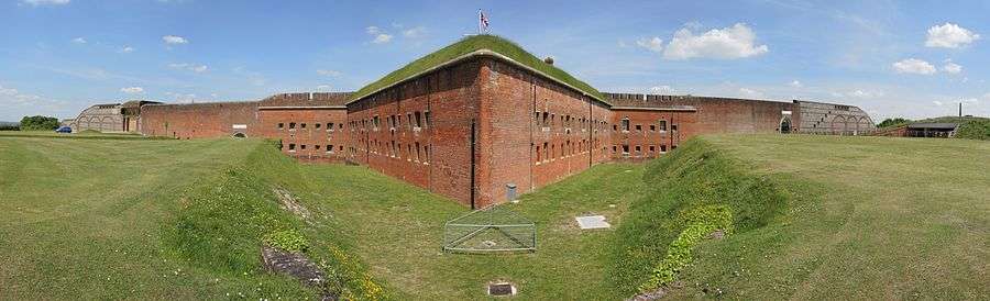
The forts on Portsdown Hill were built as a result of the 1859 Royal Commission, as part of a series of fortifications built to defend Portsmouth and its dockyard (which is 8 kilometres away) from a possible attack from inland, as the development of rifled gun barrels made it possible for an invading army to land elsewhere, circle around to the top of the hill and bombard the city from there, rendering the existing Hilsea Lines at the bottom of the ridge useless. A series of 6 forts were planned along the 10 km (6.2 mi) of the ridge. From west to east they are forts Fareham, Wallington, Nelson, Southwick, Widley and Purbrook. The line was finished off at the eastern end with Crookhorn Redoubt and Farlington Redoubt. The main threat was perceived to be from Napoleon III of France, but this receded soon after the forts' completion. Due to this they became known as "Palmerston's Folly" but, though never needed for their original purpose, were useful anti-aircraft gun emplacements during World War II.
Fort Fareham is now a small industrial estate.[6] The remains of the Fort are Grade II listed.[7]
Fort Wallington has been largely demolished to make way for an industrial estate.[8] What remains is now a Grade II Listed Building.[9]
Fort Nelson has been extensively restored as an artillery museum run by the Royal Armouries. It is a Grade I Listed Building, the highest level of designation.[10]
Fort Southwick was for many years an Admiralty Research Establishment, sold in 2003 for housing. [11] It is also now a Grade I Listed Building.[12][13]
Fort Widley is owned by Portsmouth council, hosting a stable and various community rooms. Tours run on summer weekends. It is Grade II* Listed.[14]
Fort Purbrook is open occasionally for craft fairs. It is also home to an activity centre which offers (but is not limited to) archery, rifle shooting and indoor rock-climbing. It is also Grade II* Listed.[15][16]
Guarding Fort Purbrook, the Crookhorn redoubt suffered from subsidence, and was demolished by 1876. The Farlington redoubt had only the ditches and gun positions dug, and was finally demolished in the 1970s.[17] The tunnel between Crookhorn and Purbrook has been rediscovered.[18]
SSSI
Over fifty hectares of the south face of the hill are a Site of Special Scientific Interest owing to its chalk grassland habitat. Grazing ceased in the early 1950s, and consequently the site was gradually invaded by scrub, mostly hawthorn, dogwood, and wild privet. An intensive restoration programme funded by the Countryside Commission and Portsmouth City Council was initiated in 1995; large areas of scrub have now been cleared by machine, and flowers and grasses allowed to regenerate naturally. Scrub re-encroachment is controlled by cattle and horses which graze overwinter.
Several species of butterfly became extinct owing to the loss of habitat to scrub, notably the Adonis blue, silver-studded blue, dingy skipper, and dark green fritillary. Others such as the chalkhill blue and small blue were at the brink of extinction, but are now flourishing again. Indeed, the hill has now probably the largest metapopulation of the small blue in the UK.
Portsdown also gave its name to an army estate in Singapore. Long after the British army moved out (1967) the Portsdown estate continues to thrive, with Portsdown Road the main road running through the middle.
References
- ↑ British Geological Survey 1998 Fareham England and Wales sheet 316 solid and drift geology. 1:50,000 (Keyworth, Nottingham: BGS)
- ↑ http://www.portsdown-tunnels.org.uk/index.html
- ↑ Ordnance Survey 1:25,000 scale Explorer mapping accessed 02 November 2014
- ↑ Webb, John (1977). The Siege of Portsmouth in the Civil War. Portsmouth City Council. p. 14. ISBN 0-901559-33-4.
- ↑ Penny, Legg (2010). Folklore of Hampshire. The History Press. p. 18. ISBN 978-0-7524-5179-4.
- ↑ http://www.subterraneanhistory.co.uk/2009/03/fort-fareham-hampshire.html
- ↑ Historic England. "Details from listed building database (1094240)". National Heritage List for England. Retrieved 26 June 2015.
- ↑ http://fwie.co.uk/
- ↑ Historic England. "Details from listed building database (1094233)". National Heritage List for England. Retrieved 26 June 2015.
- ↑ Historic England. "Details from listed building database (1350616)". National Heritage List for England. Retrieved 26 June 2015.
- ↑ http://www.subbrit.org.uk/rsg/sites/f/fort_southwick_comcen/index.html
- ↑ Historic England. "Details from listed building database (1167213)". National Heritage List for England. Retrieved 26 June 2015.
- ↑ Historic England. "Details from listed building database (1104368)". National Heritage List for England. Retrieved 26 June 2015.
- ↑ Historic England. "Details from listed building database (1387128)". National Heritage List for England. Retrieved 26 June 2015.
- ↑ Historic England. "Details from listed building database (1092134)". National Heritage List for England. Retrieved 26 June 2015.
- ↑ Historic England. "Details from listed building database (1387127)". National Heritage List for England. Retrieved 26 June 2015.
- ↑ http://www.portsdown-tunnels.org.uk/legends_mysteries/palmerston_forts_p1.html
- ↑ http://www.portsdown-tunnels.org.uk/legends_mysteries/palmerston_forts_p2.html
External links
- Palmerston Forts Society
- Victorian Forts data sheet on Fort Purbrook
- Victorian Forts data sheet on Fort Widley
- Victorian Forts data sheet on Fort Southwick
- Victorian Forts data sheet on Fort Wallington
- Victorian Forts data sheet on Crookhorn Redoubt
- Portsdown Tunnels
- Christ Church Portsdown
- Fort Southwick
- Fort Widley
- The Royal Armouries at Fort Nelson - Official Site.
- The Royal Armouries at Fort Nelson - Guide
- Conservation Management and Volunteering on Portsdown Hill - the SSSI bit
Coordinates: 50°51′30″N 1°06′38″W / 50.85822°N 1.11055°W