Portland Transit Mall

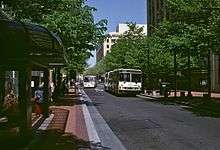
The Portland Transit Mall is a set of public transit corridors through the center of downtown Portland, Oregon, United States. More specifically, it is a pair of one-way streets—one for northbound traffic, the other for southbound—along which two of the three lanes are restricted to transit vehicles only. The transit mall opened in 1977 and until 2009, buses were the only transit vehicles using it, but in 2009 light rail was added.[1][2] Between 2007 and 2009 the mall was rebuilt and extended southwards, and it reopened for buses on May 24, 2009.[2] Light rail service on the mall was introduced on August 30, 2009, with the shifting of the MAX Yellow Line to the mall from its original routing in downtown,[3] and a second MAX line, the Green Line, began serving the mall on September 12, 2009.[4] From fall 2009 to July 2014, the Portland Vintage Trolley also served the transit mall on certain Sundays. Although the mall's transit stops are mainly served by TriMet vehicles, on weekdays buses on express routes operated by C-Tran[5] and the Columbia County Rider also serve the mall.[6] In September 2015, the new MAX Orange Line replaced the Yellow Line service in the southbound direction on the mall, on 5th Avenue, with the Orange and Yellow lines being through-routed at all times.
History
The Portland Transit Mall (formally named simply the Portland Mall) was constructed by TriMet, the Portland metropolitan area's regional transit agency, in 1976–77 and opened on December 11, 1977.[7][8] It was formally dedicated in March 1978. The mall comprises 5th Avenue, for southbound buses, and 6th Avenue, for northbound buses, and when first opened it involved the sections of those streets extending from West Burnside Street to SW Madison Street: the central core of downtown.
In June 1994, the mall was extended northward through Chinatown to Union Station (used by Amtrak) and the Greyhound bus depot.[9][10] Short, unconnected additions were made in the area around Portland State University in the early 2000s.
TriMet's Fareless Square (renamed the "Free Rail Zone" in 2010) encompassed the entire mall until discontinued in 2012, and these two facilities/measures, among others, have contributed to TriMet's having become one of the nation's most successful and most-studied public transportation systems.[11]
Until closing for rebuilding in 2007, the Portland Mall's design permitted private vehicle traffic to use the left lane, but only in short, two-block segments. In every third block, the lefthand (auto) lane disappeared for one block, and the otherwise three-lane-wide street became two lanes wide and restricted to buses only. In this way, two-thirds of the specific blocks along 5th Avenue and 6th Avenue remained open to cars, but use of those streets for through travel by cars was prohibited.
Design and amenities
The 1970s rebuilding of 5th and 6th avenues as transit-priority streets included several changes designed to create an environment that was more attractive and inviting to transit users and other pedestrians. Sidewalks were widened and repaved in brick, many additional trees were planted, new works of public art were commissioned and installed, and amenities such as benches and flower planters were added.

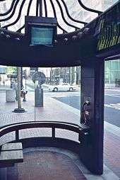
At each bus stop, a large new passenger shelter was installed. In addition to a pay telephone, every shelter was equipped with a closed-circuit television monitor giving riders information as to the next three departures on each bus route serving that particular stop.[13] This particular feature of the Portland Transit Mall was said to be a "first" for urban transit at the time (1977), having previously been used only in intercity transportation terminals, mainly airports.[12] The information system came into use in January 1978.[12] The monitors were originally black-and-white, but were replaced by color ones in 1988.
Most bus routes serving downtown Portland followed the transit mall, but a few remained on so-called "cross-mall" routings, along east-west streets, originally Morrison and Yamhill streets but shifted to Washington and Salmon streets with the start of MAX construction in the early 1980s.

With regard to operations, the mall was designed with two bus stops in each block, or about one stop every 100 feet (30 m). However, a bus operating on any given route only stopped at every fourth stop, i.e., every two blocks. TriMet adopted symbols and colors for each grouping of stops, so that bus riders could easily determine which particular stop locations were served by their routes.[14] The colors/symbols, which were marked by large signs at each stop and also shown on public schedules and maps, were as follows: Brown Beaver, Green Leaf, Yellow Rose, Orange Deer, Red Fish, Purple Raindrops and Blue Snowflake.[14][15] They were also called "sector symbols", as each one corresponded to a particular sector of the city, e.g., the Rose being for routes serving Southwest Portland and the Fish for North Portland routes.[15] When TriMet's first light rail line opened in 1986, use of the Snowflake symbol on the mall was discontinued, as all TriMet routes in that sector were curtailed to terminate at a light rail station, such as the Gateway Transit Center, and no longer traveled to downtown.

This operating configuration for the Portland Mall remained largely unchanged for 29 years, until the mall closed for rebuilding in early 2007. TriMet discontinued use of the distinctive graphic symbols used at mall stops at that time, but the symbols had already been relegated to secondary status in 2002, when they were replaced by purely geographic, letter designations such as N or NE (for North Portland or Northeast Portland) for each grouping.[16] The graphic sector symbols were retained only at a greatly reduced size on the mall signs (much smaller in size than the new letter indications) and were no longer used at all in other TriMet media, such as the covers of bus schedules. They disappeared entirely in January 2007.
Renovation and rebuilding

In 2004, it was decided to add MAX light rail to the transit mall,[17] as TriMet's existing MAX routing through downtown was nearing its design capacity and another line (the Green Line) was being planned and was expected to be added to the system within a few years. Also, the mall was approaching three decades of use, and was in need of a heavy renovation. TriMet and transportation planners from the city and Metro studied how best to accommodate both buses and light rail on the mall. During this process, it was also decided, at the urging of the downtown business community,[18] to reconfigure the mall's traffic lanes in such a way as to permit autos and other private traffic to use the left lane for the entire lengths of 5th and 6th avenues, a controversial decision. The project would also extend the mall south, from Madison Street all the way to the southern end of downtown and of Fareless Square, at the Stadium Freeway (I-405), thereby reaching Portland State University.
The Portland Transit Mall temporarily closed for rebuilding on January 14, 2007.[19] The work carried out over the next two years included the addition of light rail tracks and widening, to three lanes, all of the few south-of-Burnside sections which had previously been intentionally narrowed (by the original 1970s design) to two lanes and bus-only. During the lengthy closure, all bus routes using the mall were diverted to other streets, many to the nearby pair of 3rd Avenue (southbound) and 4th Avenue (northbound), where they had to share all traffic lanes with private vehicles but with parking temporarily removed at all of the new bus stops. Some routes were cut back to the southern part of downtown, making a loop along Columbia and Jefferson Streets.[20]
In 2007, local officials and businessmen expressed confidence that the renovation and extension of the transit mall would foster major new property redevelopment in downtown over the next several years.[21]
The mall reopened for buses on May 24, 2009.[1][22] Three months later, on August 30, 2009, MAX light rail began serving the mall, when the Yellow Line was shifted from its original (2004) downtown routing.[3] On September 12, 2009, the new Green Line opened, and it serves the transit mall as well.[4]


In the new design, MAX stops are located every 4–5 blocks, and a bus (on a given route) also stops only every 4–5 blocks. Groupings of stops are marked by letters: A, B, C or D on 5th Avenue, and W, X, Y or Z on 6th Avenue. All of the few routes that were shortened slightly, to terminate in the southern part of downtown, when the mall closed for rebuilding in 2007, have been permanently revised so as to no longer serve the mall, where replacement service is now being provided by light rail. The mall is currently served by 17 TriMet bus routes, six of which only operate in peak hours (at least on that part of their route).
Although cars and trucks are now allowed to use the left lane for the entire length of the transit mall, they are—with the exception of a very few locations—not permitted to turn right at any intersections. A motorist wanting to turn right from the transit mall must turn left, and make two additional left turns, to end up in the desired direction. This prevents cars' making right turns into the path of an oncoming bus or light rail car, which might be unable safely to stop in time to prevent a serious collision.
Vintage Trolley service
On September 13, 2009, the Sundays-only Portland Vintage Trolley service moved to the transit mall from a different route it had followed since 1991.[23] The trolley cars served the full length of the mall, from Union Station to Portland State University.[24] However, the Vintage Trolley service was discontinued in 2014, running for the last time on July 6, 2014.[25]
MAX Mall Shuttle
The MAX Mall Shuttle was a service that operated from 2009 until 2011, weekday afternoons only. It was introduced on September 14, 2009,[26] as a supplement to the light-rail service provided on the mall by the Yellow and Green lines[27] and operated only between Union Station and PSU, about every 30 minutes on weekdays from noon until 5:30 p.m.[27] TriMet discontinued this supplementary shuttle service effective June 5, 2011.[28][29] Along with bus service, the mall continues to be served by two MAX lines in each direction – Green and Yellow northbound and Green and Orange southbound – which provide a combined average headway of 7.5 minutes in each direction at most times.
See also
- Fareless Square
- List of TriMet transit centers
- MAX Light Rail
- Portland Streetcar
- Transportation in Portland, Oregon
References
- 1 2 Redden, Jim (May 21, 2009). "TriMet: Mall can be safe, orderly". Portland Tribune. Retrieved July 6, 2013.
- 1 2 Rivera, Dylan (May 26, 2009). "Buses return to Portland's revamped transit mall". The Oregonian. Retrieved April 9, 2014.
- 1 2 "New MAX line opens downtown". Portland Tribune. August 28, 2009. Retrieved May 13, 2014.
- 1 2 Rivera, Dylan (September 12, 2009). "Riders pack MAX Green Line on first day of service". The Oregonian. Retrieved April 9, 2014.
- ↑ "Traveling to and from Portland". C-Tran. Retrieved July 14, 2011.
- ↑ "St. Helens-Scappoose to Downtown Portland" (PDF). Columbia County Rider. March 21, 2014. Retrieved April 9, 2014.
- ↑ "Mall makes it". (December 12, 1977). The Oregonian, p. A1.
- ↑ "Mall enters future - and it works!" (March 19, 1978). The Sunday Oregonian, p. M11. Excerpt: "Although the Portland Mall has [now] been officially dedicated, it has been in full operation since December."
- ↑ Oliver, Gordon (June 20, 1994). "More mall for all". The Oregonian, p. B1.
- ↑ "The TriMet Story". TriMet. Retrieved 2009-10-10.
- ↑ "Awards & Recognition". TriMet. Retrieved 2009-10-10.
- 1 2 3 "Bus rider information system begins Sunday" (January 20, 1978). The Oregonian, p. C4.
- ↑ "Bus kiosks chock full of trip-planning aids" [headline is not referring to the shelters] (March 19, 1978). The Sunday Oregonian (Special Section), p. M6.
- 1 2 Graydon, Charlotte (March 19, 1978). "Tri-Met uses symbols to designate bus lines". The Sunday Oregonian, p. M7.
- 1 2 "Tri-Met Sector Symbols". Tri-Met. September 1998. Archived from the original on 1999-11-28.
- ↑ "September Service Changes". Tri-Met. September 2002. Archived from the original on 2002-09-24.
- ↑ Redden, Jim (November 19, 2004). "Transit mall redo: Riches, ruin or ...". Portland Tribune. Archived from the original on March 31, 2012. Retrieved August 21, 2012.
- ↑ Goldfield, Robert (November 8, 2002). "Business alliance making case for bus mall change". Portland Business Journal. Retrieved 2009-06-04.
- ↑ Redden, Jim (January 12, 2007). "Bye-bye, bus mall as we know it". Portland Tribune. Archived from the original on February 24, 2012. Retrieved 2014-05-13.
- ↑ "All buses move off the Portland Mall January 14th". TriMet. January 2, 2007. Archived from the original on May 7, 2007. Retrieved June 11, 2012.
- ↑ Redden, Jim (November 2, 2007). "Projects will alter city core: Transit mall remake is catalyst for 50 new redevelopment ventures". Portland Tribune. Retrieved May 13, 2014.
- ↑ Rose, Joseph (May 21, 2009). "Welcome home: Buses return to Portland Mall". The Oregonian. Retrieved 2009-05-25.
- ↑ "Vintage Trolley 2012 Schedule on the Portland Mall". Portland Vintage Trolley website. Archived from the original on February 1, 2013. Retrieved February 6, 2014.
- ↑ "Portland's Vintage Trolley". TriMet. 2014. Archived from the original on July 13, 2014. Retrieved January 2, 2015.
- ↑ "Vintage Trolley Has Ceased Operation". Portland Vintage Trolley website. September 2014. Retrieved January 2, 2015.
- ↑ "MAX Light Rail Service Begins on the Portland Mall". City of Portland's Office of Neighborhood Involvement. August 17, 2009. Retrieved 2009-10-10.
- 1 2 "Portland Transit Mall Bus Stops and MAX Stations from Union Station to PSU". TriMet. 2009. Archived from the original on June 13, 2010. Retrieved 2014-05-13.
- ↑ Rose, Joseph (June 3, 2011). "TriMet will make several seasonal bus line adjustments Sunday". The Oregonian. Retrieved May 13, 2014.
- ↑ "MAX Mall Shuttle". TriMet. 2011. Archived from the original on May 13, 2014. Retrieved 2014-05-13.
External links
| Wikimedia Commons has media related to Portland Transit Mall. |
Coordinates: 45°31′08″N 122°40′44″W / 45.519°N 122.679°W