Portes, Gard
| Portes | ||
|---|---|---|
|
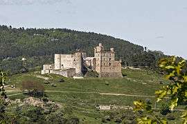
Chateau | ||
| ||
 Portes | ||
|
Location within Occitanie region  Portes | ||
| Coordinates: 44°16′17″N 4°01′15″E / 44.2714°N 4.0208°ECoordinates: 44°16′17″N 4°01′15″E / 44.2714°N 4.0208°E | ||
| Country | France | |
| Region | Occitanie | |
| Department | Gard | |
| Arrondissement | Alès | |
| Canton | Génolhac | |
| Intercommunality | Pays Grand’Combien | |
| Government | ||
| • Mayor (2008–2014) | René Doussières | |
| Area1 | 14.42 km2 (5.57 sq mi) | |
| Population (2008)2 | 362 | |
| • Density | 25/km2 (65/sq mi) | |
| Time zone | CET (UTC+1) | |
| • Summer (DST) | CEST (UTC+2) | |
| INSEE/Postal code | 30203 / 30530 | |
| Elevation |
279–735 m (915–2,411 ft) (avg. 550 m or 1,800 ft) | |
|
1 French Land Register data, which excludes lakes, ponds, glaciers > 1 km² (0.386 sq mi or 247 acres) and river estuaries. 2 Population without double counting: residents of multiple communes (e.g., students and military personnel) only counted once. | ||
.svg.png)
Portes is a commune in the Gard department in southern France.
Population
| Historical population | ||
|---|---|---|
| Year | Pop. | ±% |
| 1793 | 1,351 | — |
| 1800 | 1,353 | +0.1% |
| 1806 | 1,385 | +2.4% |
| 1821 | 1,450 | +4.7% |
| 1831 | 939 | −35.2% |
| 1836 | 935 | −0.4% |
| 1841 | 945 | +1.1% |
| 1846 | 1,126 | +19.2% |
| 1851 | 1,169 | +3.8% |
| 1856 | 2,983 | +155.2% |
| 1861 | 2,512 | −15.8% |
| 1866 | 2,072 | −17.5% |
| 1872 | 1,128 | −45.6% |
| 1876 | 1,271 | +12.7% |
| 1881 | 1,142 | −10.1% |
| 1886 | 1,147 | +0.4% |
| 1891 | 1,189 | +3.7% |
| 1896 | 1,253 | +5.4% |
| 1901 | 1,103 | −12.0% |
| 1906 | 1,109 | +0.5% |
| 1911 | 1,108 | −0.1% |
| 1921 | 924 | −16.6% |
| 1926 | 979 | +6.0% |
| 1931 | 975 | −0.4% |
| 1936 | 930 | −4.6% |
| 1946 | 903 | −2.9% |
| 1954 | 787 | −12.8% |
| 1962 | 785 | −0.3% |
| 1968 | 579 | −26.2% |
| 1975 | 388 | −33.0% |
| 1982 | 369 | −4.9% |
| 1990 | 313 | −15.2% |
| 1999 | 310 | −1.0% |
| 2008 | 362 | +16.8% |
See also
References
| Wikimedia Commons has media related to Portes (Gard). |
This article is issued from Wikipedia - version of the 3/13/2014. The text is available under the Creative Commons Attribution/Share Alike but additional terms may apply for the media files.