Port of Felixstowe
| Port of Felixstowe | |
|---|---|
 | |
| Location | |
| Country | United Kingdom |
| Location | Felixstowe |
| Coordinates | 51°57′10″N 1°18′34″E / 51.9529°N 1.3095°E |
| Details | |
| Opened | 1875 |
| Operated by | Felixstowe Dock and Railway Company |
| Owned by | Hutchison Port Holdings |
| Type of harbor | Container port |
| Size | 3,383 ha (8,360 acres) |
| Available berths | 9 |
| Employees | 2,500 (2014) |
| Chief Executive Officer | Clemence Cheng |
| Statistics | |
| Vessel arrivals | 3,000 sea = www.portoffelixstowe.co.uk |
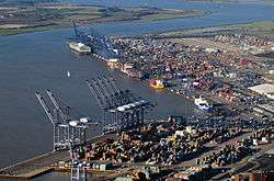
The Port of Felixstowe, in Felixstowe, Suffolk is the United Kingdom's busiest container port,[1] dealing with 42% of Britain's containerised trade.[2][3] In 2011, it was ranked as the 35th busiest container port in the world and Europe's sixth busiest. The port handled 3.74 million twenty-foot equivalent units (TEU) of traffic in 2011.[1]
The port is operated by the Felixstowe Dock and Railway Company which was set up under an Act of Parliament, the Felixstowe Railway and Pier Act 1875 and so, is one of the few limited companies in the UK that do not have the word "Limited" in their name.[4] Much of the land on which it sits is owned by Trinity College, Cambridge which in the 1930s bought some land near Felixstowe which included a dock which was too small to be included in the National Dock Labour Scheme. In 1967, it set up Britain's first container terminal for £3.5m in a deal with Sea-Land Service.[5] Because container shipping is much more economically efficient in bulk, this early start led to it becoming the UK's largest container port, despite its previous insignificance to the shipping market.
Felixstowe is owned by Hutchison Port Holdings (HPH) Group. The port has always been privately owned. In 1951, Gordon Parker, an agricultural merchant, bought the Felixstowe Dock & Railway Company, which at the time was handling only grain and coal. In 1976, Felixstowe was bought by European Ferries. In June 1991, P&O sold Felixstowe to Hutchison Whampoa of Hong Kong for £90m. In June 1994, Hutchison Whampoa's Hutchison International Port Holdings bought out Orient Overseas International's 25% stake in Felixstowe for £50m.
The port has its own Port of Felixstowe Police, fire, and ambulance services.
Description
Terminals
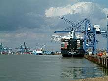

The port has two main container terminals, Trinity and Landguard as well as a RO-RO terminal.
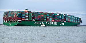
There is a continuous quay of over 2.3 kilometres (1.4 mi), equipped with 29 ship-to shore gantry cranes. The main navigation channel is dredged to 14.5 metres below chart datum, with a maximum depth of 15 metres alongside the quay. This allows Felixstowe to accommodate the world's latest generation of deep-draughted post-Panamax vessels and the much larger Maersk Triple E class, launched in 2013 and capable of carrying 18,000 TEUs.[3]
Transport connections
The A14 connects the port to the English Midlands via the M6, the north via the M1 and M6 and A1 and via the A12 to London.
Each terminal has its own rail terminal which connects to the Felixstowe Branch Line.
Seafarers and crew welfare
Seafarers' welfare charity Apostleship of the Sea, which provides practical and pastoral support to seafarers, has a port chaplain based at Felixstowe port.
Current developments
Felixstowe South
| Location | Felixstowe |
|---|---|
| Proposer | Hutchison Whampoa |
In 2008, work began on the construction and reconfiguration of Felixstowe South terminal creating 1,300 m of quay served by 13 new ship-to-shore gantry cranes. Work will be carried out in two stages with 750 m of sea wall complete by the end of 2010 and stage which is expected to open in 2014. This new terminal will have a clearance of 16 m and gantries suited for extra large box carriers.[6]
Felixstowe and Nuneaton freight capacity scheme
The railway track between Felixstowe and Nuneaton has been upgraded to allow for more freight trains by clearing the route to W10 loading gauge, allowing 'Hi-cube' shipping containers to be carried between the Port of Felixstowe and the West Coast Main Line at Nuneaton. The West Coast Main Line had previously been cleared to W10 and the route from Nuneaton to Birmingham was already cleared to W12.[7]
This work will accommodate additional freight traffic as a result of 'Felixstowe South' expansion at the Port of Felixstowe. It will also allow the newer high-cube containers to be carried by train - and the percentage of these containers is expected to increase from 30% in 2007 to 50% in 2012.[8] Network Rail completed the gauge enhancement from Ipswich to Peterborough in 2008.[9] Work should be completed by 2014.[10] at an estimated cost of £291 million.[11]
Copdock Roundabout
As part of the Felixstowe South development, Hutchison Ports will provide financial support intended to increase capacity at the Copdock interchange (J55) between the A14 and the A12.[12]
References
- 1 2 Journal of Commerce: THE JOC TOP 50 WORLD CONTAINER PORTS
- ↑ http://www.portoffelixstowe.co.uk/
- 1 2 Kremer, William (18 February 2013). "How much bigger can container ships get?". BBC World Service. BBC News. Retrieved 19 February 2013.
- ↑ "The Felixstowe Dock and Railway Company (Land Acquisition) Order 2007 (No. 3345)". Statute Law. Retrieved 2010-03-23.
- ↑ Levinson, Marc (2008). The Box. Princeton University Press. p. 204. ISBN 978-0691136400.
- ↑ "Felixstowe South reconfiguration is started". Century Haixin International Logistics (Shenzhen). Retrieved 2009-07-01.
- ↑ "Felixstowe - Nuneaton". Railway people. Retrieved 2010-05-16.
- ↑ "£132m boost for rail freight". Logistics manager. Retrieved 2010-05-16.
- ↑ "FUTURE DEVELOPMENT". Port of Felixstowe. Retrieved 2010-01-11.
- ↑ "Enhancements programme: statement of scope, outputs and milestones" (PDF). Network Rail. 2009-03-31. Retrieved 2009-09-29.
- ↑ "Presentation to Regional Transport Forum". Network Rail. 2009-02-10. Retrieved 2009-09-29.
- ↑ "The effect of the proposed development on safety and the free flow of traffic and its consistency with national transport planning policies". Department for Transport. Retrieved 2010-05-16.
Further reading
- BRITISH TRANSPORT DOCKS (FELIXSTOWE) BILL Discussion in the Commons - 1976
- Thinking inside the box BBC News article about growth of the port
External links
| England | |
|---|---|
| Wales | |
| Scotland | |
| Northern Ireland | |
Coordinates: 51°57′15″N 1°18′37″E / 51.954171°N 1.310158°E