Port del Cantó
| Port del Cantó | |
|---|---|
|
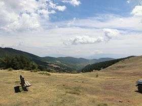
A view from the summit of the Port del Cantó | |
| Elevation | 1,730 metres (5,680 ft)[1] |
| Range | Pyrenees |
| Coordinates | 42°22′17.20″N 1°14′20.23″E / 42.3714444°N 1.2389528°ECoordinates: 42°22′17.20″N 1°14′20.23″E / 42.3714444°N 1.2389528°E |
 Port del Cantó | |
The Port del Cantó, or Coll del Cantó or Coll de la Pedra del Cantó, is a mountain pass at an altitude of 1,730 metres (5,680 ft)[1] located at the border of the municipalities of Soriguera, in the comarca of Pallars Sobirà, and Montferrer i Castellbò in the comarca of Alt Urgell in Catalonia, Spain.
The pass is located at kilometre 260 of the N-260 road.
It is on the ridge which connects the Serra Seca, to the north, with the Serrat de Pratprimer to the south.
The route from the western side will be used on Stage 9 of the 2016 Tour de France.[2]
References
- 1 2 "Port del Canto". Catena Cycling. Retrieved 7 July 2016.
- ↑ "TDF16 ET09 parcours" (PDF). Tour de France. Amaury Sport Organisation. Retrieved 8 July 2016.
This article is issued from Wikipedia - version of the 11/17/2016. The text is available under the Creative Commons Attribution/Share Alike but additional terms may apply for the media files.