Port Washington North, New York
| Port Washington North, New York | |
|---|---|
| Village | |
| Village of Port Washington North | |
| Nickname(s): Port North | |
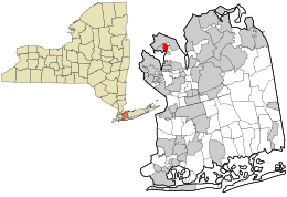 Location in Nassau County and the state of New York. | |
 Location within the state of New York | |
| Coordinates: 40°50′41″N 73°42′7″W / 40.84472°N 73.70194°WCoordinates: 40°50′41″N 73°42′7″W / 40.84472°N 73.70194°W | |
| Country | United States |
| State | New York |
| County | Nassau |
| Government | |
| • Mayor | Robert Weitzner |
| Area | |
| • Total | 0.5 sq mi (1.3 km2) |
| • Land | 0.5 sq mi (1.2 km2) |
| • Water | 0.0 sq mi (0.1 km2) |
| Elevation | 26 ft (8 m) |
| Population (2010) | |
| • Total | 3,154 |
| Time zone | Eastern (EST) (UTC-5) |
| • Summer (DST) | EDT (UTC-4) |
| FIPS code | 36-59531 |
| GNIS feature ID | 0960980 |
| Website |
www |
Port Washington North is a village in Nassau County, New York, United States. The population was 3,154 at the 2010 census.
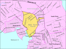
The Village of Port Washington North is in the Town of North Hempstead.
Geography
Port Washington North is located at 40°50′41″N 73°42′7″W / 40.84472°N 73.70194°W (40.844748, -73.701855).[1]
According to the United States Census Bureau, the village has a total area of 0.5 square miles (1.3 km2), of which, 0.5 square miles (1.3 km2) of it is land and 0.04 square miles (0.10 km2) of it (4.00%) is water.
Demographics
| Historical population | |||
|---|---|---|---|
| Census | Pop. | %± | |
| 1940 | 628 | — | |
| 1950 | 650 | 3.5% | |
| 1960 | 722 | 11.1% | |
| 1970 | 2,883 | 299.3% | |
| 1980 | 3,147 | 9.2% | |
| 1990 | 2,736 | −13.1% | |
| 2000 | 2,700 | −1.3% | |
| 2010 | 3,154 | 16.8% | |
| Est. 2015 | 3,207 | [2] | 1.7% |
As of the census[4] of 2000, there were 2,700 people, 1,063 households, and 767 families residing in the village. The population density was 5,624.8 people per square mile (2,171.8/km²). There were 1,071 housing units at an average density of 2,231.2 per square mile (861.5/km²). The racial makeup of the village was 86.78% White, 1.15% African American, 0.04% Native American, 9.15% Asian, 1.00% from other races, and 1.89% from two or more races. Hispanic or Latino of any race were 6.30% of the population.
There were 1,063 households out of which 31.7% had children under the age of 18 living with them, 61.8% were married couples living together, 7.6% had a female householder with no husband present, and 27.8% were non-families. 24.4% of all households were made up of individuals and 10.3% had someone living alone who was 65 years of age or older. The average household size was 2.53 and the average family size was 2.99.
In the village the population was spread out with 22.7% under the age of 18, 4.8% from 18 to 24, 28.8% from 25 to 44, 29.0% from 45 to 64, and 14.7% who were 65 years of age or older. The median age was 41 years. For every 100 females there were 94.9 males. For every 100 females age 18 and over, there were 92.1 males.
The median income for a household in the village was $89,287, and the median income for a family was $100,730. Males had a median income of $75,427 versus $52,315 for females. The per capita income for the village was $46,378. About 4.1% of families and 5.5% of the population were below the poverty line, including 4.5% of those under age 18 and 2.1% of those age 65 or over.
References
- ↑ "US Gazetteer files: 2010, 2000, and 1990". United States Census Bureau. 2011-02-12. Retrieved 2011-04-23.
- ↑ "Annual Estimates of the Resident Population for Incorporated Places: April 1, 2010 to July 1, 2015". Retrieved July 2, 2016.
- ↑ "Census of Population and Housing". Census.gov. Retrieved June 4, 2015.
- ↑ "American FactFinder". United States Census Bureau. Retrieved 2008-01-31.
External links
 |
Sands Point | | ||
| Manorhaven | |
Port Washington | ||
| ||||
| | ||||
| Manhasset Bay | Baxter Estates |