Port Meadow, Oxford
| Port Meadow | |
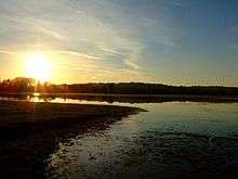 Sunset over Port Meadow |
|
 Port Meadow |
|
| OS grid reference | SP495085 |
|---|---|
| Civil parish | unparished |
| District | Oxford |
| Shire county | Oxfordshire |
| Region | South East |
| Country | England |
| Sovereign state | United Kingdom |
| Post town | Oxford |
| Postcode district | OX2 |
| Dialling code | 01865 |
| Police | Thames Valley |
| Fire | Oxfordshire |
| Ambulance | South Central |
| EU Parliament | South East England |
| UK Parliament | Oxford West and Abingdon |
| Website | Oxford City Council |
|
|
Coordinates: 51°46′12″N 1°17′02″W / 51.770°N 1.284°W
Port Meadow is a large meadow of open common land beside the River Thames to the north and west of Oxford, England.[1]
Overview
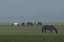
The meadow is an ancient area of grazing land, still used for horses and cattle, and has never been ploughed, at least for around 4,000 years. It is said that in return for helping to defend the kingdom against the marauding Danes, the Freemen of Oxford were given the 300 acres (120 ha) of pasture next to the River Thames by Alfred the Great who, legend has it, founded the city in the 10th century. The Freemen's collective right to graze their animals free of charge is recorded in the Domesday Book of 1086 and has been exercised ever since.
The meadow runs from Jericho to Wolvercote (where it becomes Wolvercote Common) along the east (left) bank of the River Thames, with the Cotswold Line railway, the Oxford Canal and the suburb of North Oxford further to the east, and the village of Binsey to the west. Access to Port Meadow is via Walton Well Road or Aristotle Lane in the south (or from the south via Roger Dudman Way or the Thames Path) or from Wolvercote via Wolvercote Common in the north. It is a typical English flood-meadow and is a favourite area for walking, with easy access from the city of Oxford. It is also a Site of Special Scientific Interest. At the southern end of the meadow is Fiddler's Island in the River Thames. In the winter the meadow sometimes floods; if frozen it forms a huge and relatively safe area for skating. In late spring vast areas are carpeted with buttercups. Horses, cattle and geese graze the meadow and many birds can often be seen. At the eastern edge of Port Meadow, just north of the entrance from Aristotle Lane, is Burgess Field, a reclaimed landfill site and home to a nature reserve. It covers an area of about 85 acres (35 hectares) and a circular path around the edge of the reserve takes you through some small copses.
The River Thames (known as the Isis in this area) flows past this large grazing meadow. This is where the Reverend Charles Lutwidge Dodgson (Lewis Carroll) and the Reverend Robinson Duckworth rowed up the river on July 4, 1862 with three young girls — Lorina, Alice, and Edith Liddell. While journeying slowly from Folly Bridge to near Godstow, Dodgson began at their request to make up a story that later was expanded into Alice's Adventures in Wonderland.
Because the meadow has never been ploughed, it contains well preserved archaeological remains, some of which survive as residual earthworks. Of particular note are several Bronze Age round barrows, an area of Iron Age settlement, and the foundations of 17th-century fortifications from the Parliamentary siege of Oxford during the English Civil War.
In the 17th and 18th centuries the meadow was used for horse racing, and low stone bridges laid over washes and ditches for this purpose still survive.[2]
During the First World War part of Port Meadow was used to train the Royal Flying Corps and turned into a military aerodrome. Fifteen air crew and pilots were killed flying from Port Meadow or close by. [3] In 1940, during the Second World War, a camp was set up on the meadow for military personnel evacuated from Dunkirk.
In the 1980s and 1990s, the meadow was known as a location for free festivals and raves.[4][5][6]
Just across the Thames is Bossom's boatyard, with a small marina and Medley Footbridge across the Thames. The Medley Sailing Club, the furthest upstream sailing club on the River Thames, is on the western bank. To the south is the start of the Castle Mill Stream and Cripley Meadow, largely consisting of allotments.
Development
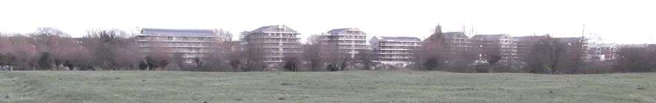
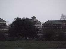
From 2012, the Oxford University Estates Directorate, with the help of Longcross, have been developing the one-hectare Castle Mill site (400 m × 25 m) between the Cripley Meadow Allotments and the railway tracks, close to the southern end of Port Meadow, as extensive student accommodation.[7][8] The development has been controversial, since the four to five storey blocks overlook Port Meadow.[9] Campaigners have warned of damage to views of Oxford.[10][11] There has been an online petition[12] and a "Save Port Meadow" campaign was established in December 2012.[13] Concern has been raised by the Oxford Preservation Trust and the Green Party.[14] Anger has been caused even among members of Oxford University.[15] The development has been likened to building a "skyscraper beside Stonehenge".[16] In February 2013, Oxford City Council entered negotiations with Oxford University to reduce the height of the buildings by two storeys.[17] On 7 May 2013 the Campaign to Protect Rural England applied to the High Court for judicial review of the decision to grant planning permission on the grounds that requirements for a full Environmental Impact Assessment (EIA) were not met.
See also
- Port Meadow Halt, a former railway station on the Varsity Line
- Cripley Meadow, to the south
- Wolvercote Common, to the north
- Binsey Poplars, a 1879 poem by Gerard Manley Hopkins (1844–1889), written after the felling of a row of poplar trees on the River Thames overlooking Port Meadow
References
- ↑ Hibbert, Christopher, ed. (1988). "Port Meadow". The Encyclopaedia of Oxford. Macmillan. pp. 331–332. ISBN 0-333-39917-X.
- ↑ Historic Port Meadow to get revamp, The Oxford Times, 8 July 1998.
- ↑ "Port Meadow Aerodrome, Oxfordshire: Challenges of Training with the Royal Flying Corps, World War One At Home". BBC. Retrieved 2015-11-10.
- ↑ Oxford Free Festival 1986, UK Rock Festivals, July 2012.
- ↑ UK Police Halt Rave Party, Party Vibe, 11 August 1998.
- ↑ May Morning Tips, Road & Travel Magazine.
- ↑ "Longcross at the University of Oxford, Castle Mill Phase 2 ∙ Innovation in action". www.longcross.co.uk. Longcross. Retrieved 23 October 2012.
- ↑ "Longcross Secures Student Accommodation Project at Oxford University". www.longcross.co.uk. Longcross. July 2012. Retrieved 23 October 2012.
- ↑ "City 'has to pay a price' to preserve Green Belt". The Oxford Times. 1 November 2012. pp. 1, 3.
- ↑ Little, Reg (2 November 2012). "Save our famous views for hideous developments". The Oxford Times. Retrieved 4 November 2012.
- ↑ Little, Reg (2 November 2012). "Save our famous views for hideous developments". Oxford Mail. Retrieved 4 November 2012.
- ↑ Dhall, Sushila (2012). "Port Meadow, Oxford. Damaged views". www.thepetitionsite.com/850/008/830/port-meadow-oxford-damaged-views/. Care2petitionsite.
- ↑ "Save Port Meadow". WordPress. Retrieved 6 June 2013.
- ↑ Little, Reg (1 November 2012). "Planning: Controversy over student flats at Roger Rudman Way —The battle of Port Meadow". The Oxford Times. p. 10.
- ↑ "Tall storey". The Oxford Times. 1 November 2012. p. 32. Retrieved 4 November 2012.
- ↑ Little, Reg (7 February 2013). "Historian takes university to task over 'visual disaster' of Port Meadow flats". The Oxford Times. p. 3.
- ↑ Hughes, Pete (14 February 2013). "U-turn over meadow flats". The Oxford Times. p. 3.
External links
| Wikimedia Commons has media related to Port Meadow, Oxford. |
- Save Port Meadow website
- Port Meadow Campaign on Twitter

- Protect Port Meadow from Oxford University on Facebook
The City of Oxford | ||
|---|---|---|
| Wards, suburbs, neighbourhoods and districts |
|  |
| Civil parishes | ||
| Former district and borough | ||
| Former constituencies | ||