Port Hawkesbury
| Port Hawkesbury Gaelic: Baile a' Chlamhain / An Gut | ||
|---|---|---|
| Town | ||
| ||
| Nickname(s): Cape Breton's Front Porch | ||
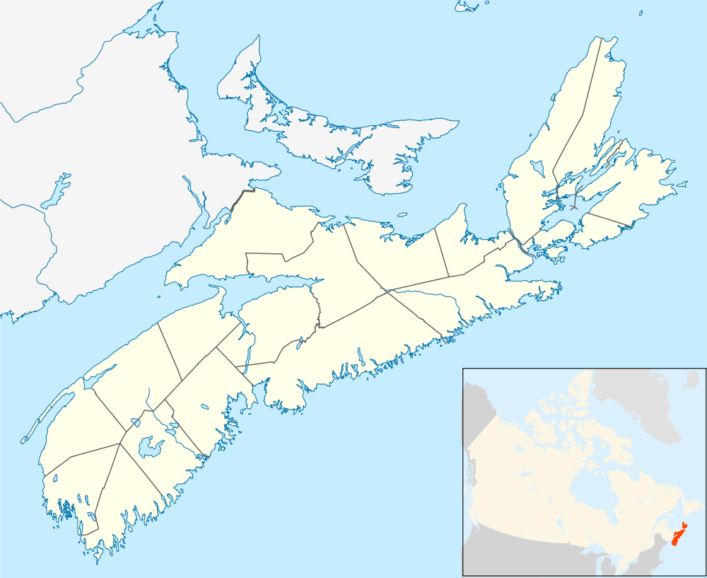 Port Hawkesbury Location of Port Hawkesbury, Nova Scotia | ||
| Coordinates: 45°36′55″N 61°21′51″W / 45.61528°N 61.36417°W | ||
| Country |
| |
| Province |
| |
| Municipality | Inverness County | |
| Founded | 1789 | |
| Incorporated | January 22, 1889 | |
| Government | ||
| • Mayor | Brenda Chisholm-Beaton[1] | |
| • Governing Body | Port Hawkesbury Town Council | |
| Area | ||
| • Total | 8.11 km2 (3.13 sq mi) | |
| Highest elevation | 54 m (177 ft) | |
| Lowest elevation | 0 m (0 ft) | |
| Population (2011) | ||
| • Total | 3,366 | |
| • Density | 433.4/km2 (1,123/sq mi) | |
| Time zone | AST (UTC-4) | |
| • Summer (DST) | ADT (UTC-3) | |
| Postal code | B9A | |
| Area code(s) | 902 | |
| Telephone Exchange | 625 | |
| Median Earnings* | $48,141 | |
| NTS Map | 011F11 | |
| GNBC Code | CBELL | |
| Website | townofporthawkesbury.ca | |
| ||
Coordinates: 45°36′55″N 61°21′51″W / 45.61528°N 61.36417°W
Port Hawkesbury (Scottish Gaelic: Baile a' Chlamhain) is a town located on the southwestern end of Cape Breton Island, on the north shore of the Strait of Canso, in the Canadian province of Nova Scotia.
The town was originally named Ship Harbour (after the harbour upon which it is located) and is largely a service centre for western Cape Breton Island with many of its residents working in large industries in an industrial park located in the adjacent community of Point Tupper, Richmond County. The town's schools are Tamarac Education Centre (Grades primary-8), SAERC (Grades 9-12) and the Strait Area Campus of the Nova Scotia Community College.
The community is named after Admiral Sir Edward Hawke.[2]
The Port
The Port of Port Hawkesbury is the second largest by tonnage annually in Canada, second only to Vancouver, British Columbia due to large volumes of crushed rock and gravel shipments and oil trans-shipments. The Port handled 31.6 million metric tonnes in 2006, 21.6 million tonnes of crude petroleum.[3] The port is served by tugs of Svitzer Towing such as the tug Point Chebucto.[4] Historically it was a stop for American coastal steam ships.[5]
History
Know by its first name as Ship Harbour, Port Hawkesbury built ships for the timber export trade in the early and mid 19th century, such as the brig James, the subject of one of the earliest ship portraits in Canada.[6] Schooners and fishing boats were also built for the inshore and banks fishery by firms such as the noted boatbuilder H.W. Embree and Sons. The port further developed in the 19th century when railway connections arrived. The construction of the Canso Causeway increased the shelter capacity of the deepwater port leading to further growth in shipping of bulk commodities and the establishment of several heavy industries such as the pulp mill.
Historical residents
- Henry Embree, noted 19th-century boatbuilder
- Henry Nicholas Paint (1830–1921), member of Parliament for Richmond county, merchant and land owner. His family (settling from Guernsey) received land grants at Belle Vue on the Strait of Canso in 1817 and at Point Tupper in 1863, and did much to develop the local communities in the area.
- Arthur John Langley (1888–1982) entrepreneur, civic politician, mayor for several terms. Owned marine railway in Point Tupper.
Climate
| Port Hawkesbury Airport | ||||||||||||||||||||||||||||||||||||||||||||||||||||||||||||
|---|---|---|---|---|---|---|---|---|---|---|---|---|---|---|---|---|---|---|---|---|---|---|---|---|---|---|---|---|---|---|---|---|---|---|---|---|---|---|---|---|---|---|---|---|---|---|---|---|---|---|---|---|---|---|---|---|---|---|---|---|
| Climate chart (explanation) | ||||||||||||||||||||||||||||||||||||||||||||||||||||||||||||
| ||||||||||||||||||||||||||||||||||||||||||||||||||||||||||||
| ||||||||||||||||||||||||||||||||||||||||||||||||||||||||||||
Port Hawkesbury experiences a Humid continental climate (Dfb). Due to the proximity to surrounding bodies of water, seasons tend to be delayed when compared to areas further inland. Precipitation is high, with the fall and winter being the wettest time of year and summer being the driest. Winters are cold, snowy and stormy with frequent snowstorms. Summer is the most pleasant time of year, with significantly less precipitation and warm temperatures.
The highest (reliable) temperature ever recorded in the strait area was 35.0 °C (95 °F) on 7 July 1912 and 19 July 1975.[8][9] The coldest temperature ever recorded was −28.5 °C (−19 °F) on 7 February 1993.[7]
| Climate data for Port Hawkesbury Airport, 1981–2010 normals, extremes 1885–present[lower-alpha 1] | |||||||||||||
|---|---|---|---|---|---|---|---|---|---|---|---|---|---|
| Month | Jan | Feb | Mar | Apr | May | Jun | Jul | Aug | Sep | Oct | Nov | Dec | Year |
| Record high °C (°F) | 17.0 (62.6) |
13.6 (56.5) |
23.7 (74.7) |
27.1 (80.8) |
31.7 (89.1) |
34.0 (93.2) |
35.0 (95) |
34.0 (93.2) |
33.0 (91.4) |
26.5 (79.7) |
25.6 (78.1) |
16.0 (60.8) |
35.0 (95) |
| Average high °C (°F) | −2.0 (28.4) |
−2.8 (27) |
1.0 (33.8) |
6.6 (43.9) |
13.2 (55.8) |
19.2 (66.6) |
22.6 (72.7) |
22.8 (73) |
18.6 (65.5) |
12.8 (55) |
7.0 (44.6) |
0.6 (33.1) |
10.0 (50) |
| Daily mean °C (°F) | −6.2 (20.8) |
−7.2 (19) |
−3.1 (26.4) |
2.7 (36.9) |
8.3 (46.9) |
13.9 (57) |
17.8 (64) |
18.2 (64.8) |
14.0 (57.2) |
9.0 (48.2) |
3.7 (38.7) |
−2.7 (27.1) |
5.7 (42.3) |
| Average low °C (°F) | −10.2 (13.6) |
−11.6 (11.1) |
−7.2 (19) |
−1.1 (30) |
3.3 (37.9) |
8.6 (47.5) |
12.9 (55.2) |
13.6 (56.5) |
9.4 (48.9) |
5.1 (41.2) |
0.4 (32.7) |
−6.0 (21.2) |
1.4 (34.5) |
| Record low °C (°F) | −27.0 (−16.6) |
−28.5 (−19.3) |
−26.7 (−16.1) |
−13.5 (7.7) |
−7.0 (19.4) |
−3.0 (26.6) |
−0.6 (30.9) |
1.1 (34) |
−5.6 (21.9) |
−7.2 (19) |
−12.2 (10) |
−24.0 (−11.2) |
−28.5 (−19.3) |
| Average precipitation mm (inches) | 121.2 (4.772) |
115.7 (4.555) |
113.4 (4.465) |
106.4 (4.189) |
98.1 (3.862) |
97.3 (3.831) |
96.2 (3.787) |
81.8 (3.22) |
116.6 (4.591) |
156.5 (6.161) |
146.9 (5.783) |
133.6 (5.26) |
1,383.6 (54.472) |
| Average rainfall mm (inches) | 55.6 (2.189) |
48.6 (1.913) |
74.2 (2.921) |
91.9 (3.618) |
97.5 (3.839) |
97.3 (3.831) |
96.2 (3.787) |
81.8 (3.22) |
116.6 (4.591) |
156.4 (6.157) |
133.1 (5.24) |
81.0 (3.189) |
1,130.1 (44.492) |
| Average snowfall cm (inches) | 65.6 (25.83) |
67.1 (26.42) |
39.3 (15.47) |
14.5 (5.71) |
0.6 (0.24) |
0.0 (0) |
0.0 (0) |
0.0 (0) |
0.0 (0) |
0.1 (0.04) |
13.8 (5.43) |
52.6 (20.71) |
253.5 (99.8) |
| Mean monthly sunshine hours | 101.4 | 120.7 | 139.3 | 156.1 | 191.2 | 221.4 | 227.3 | 224.0 | 172.7 | 137.0 | 98.8 | 78.8 | 1,868.7 |
| Source: Environment Canada[7][10][11][12][13] (Sunshine data recorded at Eddy Point) | |||||||||||||
Notable people
- Aaron Johnson, an NHL draft pick now playing with the AHL's Stockton Heat.
- Mark Day, a film and television actor now living in Toronto and Los Angeles.
- Lynn Coady is an author. Her best selling novels include Strange Heaven, Play the Monster Blind, Saints of Big Harbour, the Giller Prize nominated Antagonist (2011) and the Giller Prize Winning Hellgoing (2013).
| Historical population | ||
|---|---|---|
| Year | Pop. | ±% |
| 1901 | 633 | — |
| 1911 | 684 | +8.1% |
| 1921 | 869 | +27.0% |
| 1931 | 1,011 | +16.3% |
| 1941 | 1,031 | +2.0% |
| 1951 | 1,034 | +0.3% |
| 1956 | 1,078 | +4.3% |
| 1961 | 1,346 | +24.9% |
| 1981 | 3,850 | +186.0% |
| 1986 | 3,869 | +0.5% |
| 1991 | 3,991 | +3.2% |
| 1996 | 3,809 | −4.6% |
| 2001 | 3,701 | −2.8% |
| 2006 | 3,517 | −5.0% |
| 2011 | 3,366 | −4.3% |
| [14] [15] | ||
Media
- 101.5 (FM) - The Hawk
- SAERC FM - 93.9
- SAERC TV
The Reporter, Community Newspaper
Parks
- Burnt Island Provincial Park
- Lennox Passage Provincial Park
References
- ↑ "Chisholm-Beaton sworn in as Port Hawkesbury mayor". 101.5 FM The Hawk. 2 November 2016. Retrieved 2 November 2016.
- ↑ https://archive.org/stream/placenamesofprov00browuoft#page/116/mode/2up
- ↑ Shipping in Canada (PDF). Statistics Canada. pp. 26, 60.
- ↑ Mac Mackay, "The Announcement", Tugfax, July 23, 2010
- ↑ "Plant Line Ocean Trips". The Independent. Jul 6, 1914. Retrieved August 1, 2012.
- ↑ Charles Armour and Thomas Lackey Sailing Ships of the Maritimes, p. 23
- 1 2 3 "Port Hawkesbury A". Canadian Climate Normals 1981–2010. Environment Canada. Retrieved 16 September 2016.
- ↑ "Daily Data Report for July 1912". Canadian Climate Data. Environment Canada. Retrieved 16 September 2016.
- ↑ "Daily Data Report for July 1975". Canadian Climate Data. Environment Canada. Retrieved 16 September 2016.
- ↑ "Port Hastings". Canadian Climate Data. Environment Canada. Retrieved 16 September 2016.
- ↑ "Eddy Point". Canadian Climate Data. Environment Canada. Retrieved 16 September 2016.
- ↑ "Port Hawkesbury". Canadian Climate Data. Environment Canada. Retrieved 16 September 2016.
- ↑ "Port Hawkesbury Airport". Canadian Climate Data. Environment Canada. Retrieved 16 September 2016.
- ↑ Census 1956-1961
- ↑ I:\ecstats\Agency\BRIAN\census2
- ↑ Climate data was recorded at Port Hastings from October 1885 to June 1913 and again from June 1959 to September 1989, at Port Hawkesbury Airport from December 1985 to August 2004, at Port Hawkesbury from January 2006 to May 2009 and at Port Hawkesbury Airport from June 2010 to present.
See also
External links
| Counties | |
|---|---|
| Economic Regions | |
| Regional municipalities | |
| Municipal districts | |
| Towns | |
| Incorporated villages | |
| Lists | |
| |