Port Clarence, Alaska
| Port Clarence, Alaska | |
|---|---|
| CDP | |
|
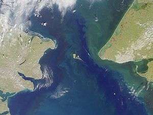
Bering Strait. Port Clarence bay is the large bight in the southeast. | |
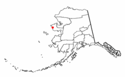 Location of PortClarence, Alaska | |
| Coordinates: 65°15′58″N 166°51′10″W / 65.26611°N 166.85278°WCoordinates: 65°15′58″N 166°51′10″W / 65.26611°N 166.85278°W | |
| Country | United States |
| State | Alaska |
| Census Area | Nome |
| Government | |
| • State senator | Donald Olson (D) |
| • State rep. | Neal Foster (D) |
| Area | |
| • Total | 36.5 sq mi (94.4 km2) |
| • Land | 35.5 sq mi (91.8 km2) |
| • Water | 1.0 sq mi (2.6 km2) |
| Elevation | 16 ft (5 m) |
| Population (2010)[1] | |
| • Total | 24 |
| • Density | 0.7/sq mi (0.3/km2) |
| Time zone | Alaska (AKST) (UTC-9) |
| • Summer (DST) | AKDT (UTC-8) |
| Area code(s) | 907 |
| FIPS code | 02-63170 |
| GNIS feature ID | 1408213 |
Port Clarence is a census-designated place (CDP) in Nome Census Area, Alaska. The population was 24 at the 2010 census.[1] It is located on the spit separating Port Clarence Bay from the Bering Strait.
History
Missionary Sheldon Jackson's greatest success with his Teller Reindeer Station at Port Clarence, figured in the Overland Relief Expedition in 1897 to save marooned whalers near Point Barrow.
During the 1898-1899 gold rush in Nome, smaller quantities of both gold and high-grade tin were mined in Port Clarence.[2]
The Harriman Alaska Expedition visited Port Clarence in 1899, making a photographic record of Alaska Natives.[3]
In 1900, the U.S. Coast and Geodetic Survey charted the coastline.[2]
The U.S. Coast Guard commissioned a 1350 ft. (411.48 metre) tall Loran-C tower in 1961. It was the tallest structure in Alaska until its demolition in 2010.[4]
Geography
Port Clarence is located at 65°15′58″N 166°51′10″W / 65.26611°N 166.85278°W (65.265974, -166.852765).[1]
According to the United States Census Bureau, the CDP has a total area of 36.5 square miles (95 km2), of which, 35.5 square miles (92 km2) of it is land and 1.0 square mile (2.6 km2) of it (2.74%) is water.
Demographics
From 1961–2010 Port Clarence was a LORAN-C station administered by the U.S. Coast Guard.[5] The LORAN-C Program was terminated Feb. 8, 2010.[6]
As of the census of 2000,[7] there were 21 people, 4 households, and 3 families residing in the CDP. The population density was 0.6 people per square mile (0.2/km²). There were 0 housing units at an average density of 0.0/sq mi (0.0/km²). The racial makeup of the CDP was 90.48% White, 4.76% (i.e., one person) Black or African American, 4.76% (i.e., one person) from other races. Hispanic or Latino of any race were 4.76% of the population (i.e., one person).
There were 4 households out of which none had children under the age of 18 living with them, none were married couples living together, and 0.0% were non-families. No households were made up of individuals and none had someone living alone who was 65 years of age or older. The average household size was 0.00 and the average family size was 0.00.
In the CDP the age distribution of the population shows 33.3% from 18 to 24, 66.7% from 25 to 44. The median age was 28 years. For every 100 females there were 2,000.0 males. For every 100 females age 18 and over, there were 2,000.0 males. (In other words, the 21 residents counted by the census included one woman and 20 men).
The median income for a household in the CDP was $0, and the median income for a family was $0. Males had a median income of $29,688 versus $0 for females. The per capita income for the CDP was $35,286. There were no families and none of the population living below the poverty line, including no under eighteens and none of those over 64.
References
- 1 2 3 "US Gazetteer files: 2010, 2000, and 1990". United States Census Bureau. 2011-02-12. Retrieved 2011-04-23.
- 1 2 http://www.akhistorycourse.org/articles/article.php?artID=66
- ↑ http://content.lib.washington.edu/harrimanweb/index.html
- ↑ Dan Joling (30 April 2010). "https://www.google.com/hostednews/ap/article/ALeqM5jaCny8J9TJJUHh8Y4dEyxzXV3X3AD9FD4HKG0". The Associated Press. Retrieved 30 April 2010. External link in
|title=(help) - ↑ http://www.uscg.mil/d17/loranportclarence/
- ↑ http://www.navcen.uscg.gov/?pageName=loranMain
- ↑ "American FactFinder". United States Census Bureau. Retrieved 2008-01-31.
Municipalities and communities of Nome Census Area, Alaska, United States | ||
|---|---|---|
| Cities |  | |
| CDP | ||
| Unincorporated community | ||
| Ghost towns | ||