Port-Gentil
| Port-Gentil Mandji | |
|---|---|
 | |
 Port-Gentil Location in Gabon | |
| Coordinates: 0°43′S 8°47′E / 0.717°S 8.783°E | |
| Country |
|
| Province | Ogooue-Maritime |
| Department | Bendje Department |
| Population (2013 census) | |
| • Total | 136,462 |
Port-Gentil or Mandji is the second-largest city of Gabon, and its leading seaport. It is the center of Gabon's petroleum and timber industries. Although it lies inshore, the nearby mainland is a remote forest area and it is not connected by road to the rest of the nation. The city lies close to Cape Lopez, the westernmost point in Gabon. It had a 2013 census population of 136,462.
In 1722, the pirates led by Bartholomew Roberts fought a battle in the Cape Lopez Bay against the Royal Navy. The encounter ended by Roberts' death. The settlement was established on Mandji Island in the delta of the Ogooué River by the French, who signed a treaty with the Orungu people in 1873. It was used as a base for the expeditions of de Brazza into the interior, then in 1894 a customs post was set up, becoming the nucleus of a trading center that included Hatton & Cookson, John Holt, Woermann, Société du Haut-Ogooué, and Compagnie d'Exploitations Forestières Africaines. The main products were initially rubber and ivory, gradually supplemented by woods, particularly okoumé for plywood.
The town was named after the French colonial administrator Émile Gentil in 1900. After World War I it became a port for timber, but it grew rapidly only after Elf began oil exploration in the area. It received its first bank branch when Bank of West Africa (BAO), opened a branch there in 1928.
A 1947 population of 4,500 grew to 21,000 by 1960. An oil refinery was established by SOGARA in the 1960s, with natural gas added in 1968.
The town is now known for its hotels and its nightlife, while attractions include the St Louis Church (built in 1927), a zoo, a casino, beaches and a golf course, as well as the wildlife in local swamps.
City Districts
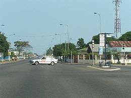
The city centre lies next to the harbour on the Port-Gentil Bay seaside. Hotels, banks, shops, and supermarkets (such as the Casino and Cecado brands) are found within the downtown area between the Avenue Savorgnan de Brazzaville and the seaside. The area also concentrates a residential compound for foreign workforce. In the southern part, the BEAC building lies next to the port. The western Atlantic seaside is scarcely populated, mainly due to the presence of strong winds and sea currents. As it is the case with other cities in Gabon, the authorities have not yet implemented the house numbering in Port-Gentil. Subsequently, the use of postal boxes is common.
Climate
Köppen-Geiger climate classification system classifies its climate as tropical wet and dry (Aw).
The highest recorded temperature was 38.0 °C (100.4 °F) on 26 February 2016; the lowest recorded temperature was 13.2 °C (55.8 °F) on 1 August 1953.[1]
| Climate data for Port-Gentil (1961–1990, extremes 1950–present) | |||||||||||||
|---|---|---|---|---|---|---|---|---|---|---|---|---|---|
| Month | Jan | Feb | Mar | Apr | May | Jun | Jul | Aug | Sep | Oct | Nov | Dec | Year |
| Record high °C (°F) | 32.6 (90.7) |
38.0 (100.4) |
34.6 (94.3) |
33.7 (92.7) |
33.2 (91.8) |
33.2 (91.8) |
30.8 (87.4) |
33.1 (91.6) |
33.3 (91.9) |
33.0 (91.4) |
34.0 (93.2) |
35.0 (95) |
38.0 (100.4) |
| Average high °C (°F) | 29.5 (85.1) |
30.2 (86.4) |
30.3 (86.5) |
30.0 (86) |
29.0 (84.2) |
26.7 (80.1) |
25.9 (78.6) |
27.4 (81.3) |
27.7 (81.9) |
28.3 (82.9) |
28.6 (83.5) |
29.0 (84.2) |
28.5 (83.3) |
| Daily mean °C (°F) | 26.9 (80.4) |
27.3 (81.1) |
27.3 (81.1) |
27.1 (80.8) |
26.6 (79.9) |
24.4 (75.9) |
23.5 (74.3) |
24.7 (76.5) |
25.4 (77.7) |
25.9 (78.6) |
26.1 (79) |
26.5 (79.7) |
26.0 (78.8) |
| Average low °C (°F) | 24.2 (75.6) |
24.4 (75.9) |
24.3 (75.7) |
24.2 (75.6) |
24.1 (75.4) |
22.0 (71.6) |
21.1 (70) |
21.9 (71.4) |
23.0 (73.4) |
23.5 (74.3) |
23.5 (74.3) |
24.0 (75.2) |
23.3 (73.9) |
| Record low °C (°F) | 17.6 (63.7) |
19.4 (66.9) |
19.5 (67.1) |
18.0 (64.4) |
19.0 (66.2) |
16.4 (61.5) |
16.0 (60.8) |
13.2 (55.8) |
18.2 (64.8) |
19.5 (67.1) |
15.8 (60.4) |
18.2 (64.8) |
13.2 (55.8) |
| Average precipitation mm (inches) | 247.8 (9.756) |
177.8 (7) |
266.8 (10.504) |
299.3 (11.783) |
150.6 (5.929) |
11.5 (0.453) |
3.4 (0.134) |
5.0 (0.197) |
31.8 (1.252) |
179.9 (7.083) |
352.2 (13.866) |
227.1 (8.941) |
1,953.2 (76.898) |
| Average precipitation days | 14.8 | 12.7 | 16.4 | 15.5 | 10.2 | 0.9 | 0.5 | 3.4 | 9.0 | 17.4 | 19.6 | 13.9 | 134.3 |
| Average relative humidity (%) | 84 | 84 | 83 | 84 | 85 | 84 | 83 | 82 | 82 | 84 | 86 | 84 | 84 |
| Mean monthly sunshine hours | 150.4 | 160.8 | 154.5 | 151.5 | 147.8 | 156.3 | 163.1 | 135.3 | 125.7 | 116.1 | 115.1 | 147.2 | 1,723.8 |
| Source #1: NOAA[2] | |||||||||||||
| Source #2: Meteo Climat (record highs and lows)[1] | |||||||||||||
Transportation
Port Gentil is technically on an island, and no bridge connects it to the mainland.
The limited number of paved roads within the city are also poorly maintained.The roads are paved in the inner city up to the outskirts of the new residential districts in N'Tchengue, where sandy paths with frequent potholes prevail. Traffic jams are common in road junctions such as the Carrefour Tobia or Léon Mba, close to the downtown area. There are plenty of shared taxi services for which the price of a drive is negotiable, starting usually at 400 CFA Francs. The taxi fare usually doubles for night drives. A premium price (doubled fare) is requested for passengers travelling beyond paved roads, given the hardships of the road, lack or non existence of illuminated roads at night, or pedestrians randomly walking on the road. Most of the cars are obsolete given the over-expensiveness of new imported cars. Furthermore, the lack of local car spareparts manufacturers underscores the need to import such parts from as far as Europe, the increased price as well as the lengthy delivery duration penalize altogether the traffic.
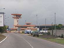
The city has an airport, Port-Gentil International Airport, serving as the main channel of transportation with the world. Regular flights connect it with Libreville, capital of Gabon. Oil company charters to other destinations are a regular sight from the airport.
Healthcare
Hospitals within Port-Gentil include:
* Clinique Mandji, located in the Littoral district on the Route de la Sobraga,
* Clinique du Littoral, located on the Boulevard du Gouverneur Pélieu,
* Centre du Traitement Ambulatoire on the road to N'Tchengue.
Education
Schools include:
- École Mixte Port-Gentil or École publique conventionnée de Port-Gentil[3][4]
- École primaire Léopold Sédar Senghor (French primary school)[5]
- Lycée Français Victor Hugo de Port-Gentil (French secondary school)
Notable residents
- Stephane Lasme, professional basketball player
Gallery


References
- 1 2 "Station Port Gentil" (in French). Meteo Climat. Retrieved 11 June 2016.
- ↑ "Port-Gentil Climate Normals 1961–1990". National Oceanic and Atmospheric Administration. Retrieved March 8, 2015.
- ↑ Home page (Archive). École Mixte Port-Gentil. Retrieved on May 3, 2015.
- ↑ "École publique conventionnée de Port-Gentil." AEFE. Retrieved on May 3, 2015.
- ↑ "Accueil" (Archive). École primaire Léopold Sédar Senghor. Retrieved on May 3, 2015.
- David E. Gardinier, Historical Dictionary of Gabon, 2nd ed. (The Scarecrow Press, 1994) p. 275–276
- Port Gentil - the world's most expensive city, Time Magazine online, Mar 16 2007
Coordinates: 0°43′S 8°47′E / 0.717°S 8.783°E