Poronay River
| Poronay (Поронай) | |
| River | |
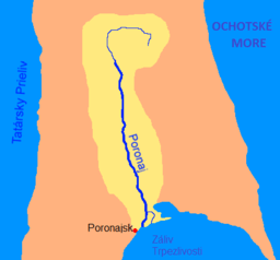 Map of the Poronay River watershed | |
| Name origin: Ainu for "big river"[1] | |
| Country | Russia |
|---|---|
| State | Sakhalin Oblast |
| Source | Mount Nevel |
| - location | East Sakhalin Mountains |
| - coordinates | RU 50°22′19.30″N 143°10′56.33″E / 50.3720278°N 143.1823139°E |
| Mouth | Gulf of Patience |
| - location | Sea of Okhotsk |
| - coordinates | RU 49°13′31.77″N 143°07′23.44″E / 49.2254917°N 143.1231778°ECoordinates: RU 49°13′31.77″N 143°07′23.44″E / 49.2254917°N 143.1231778°E |
| Length | 350 km (217 mi) |
| Basin | 7,990 km2 (3,085 sq mi) |
| Discharge | for Pacific Ocean[2] |
| - average | 120 m3/s (4,238 cu ft/s) |
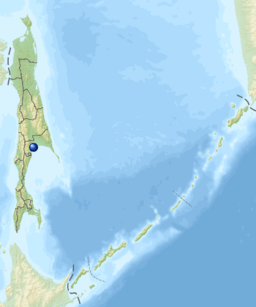 Location of the mouth of the Poronay River within Sakhalin Oblast | |
The Poronay River (Russian: Поронай) is the longest river on the island of Sakhalin in Russia. It flows in a southerly direction through Tym, Smirnykhovsky and Poronaysky Districts.
Geography
The river begins on Mt. Nevel in the East Sakhalin Mountains, flows south through the swampy wetlands of the Tym-Poronay Valley, and enters the Sea of Okhotsk in the Gulf of Patience. 10 km (6 mi) before it enters the sea, the river divides into two arms, which flow into the sea 5 km (3 mi) apart from each other. The two branches create a marshy river island in the middle. The town of Poronaysk is located near the western mouth of the river.
The Poronay River is crossed by only two bridges, one rail and one road bridge. Both bridges are next to each other, in the middle of the river between the towns of Pobedino and Pervomaisk. The river valley, especially the area between the downstream Poronay and the Deer River (a small river to the east), has many lakes. The Poronay river system is a rich breeding ground for salmon[3] and other anadromous fish, as well as freshwater fish such as Amur pike.[4]
Hydrology
The river is fed by both snowmelt and rain. Average water flow is 120 m³/s. The highest level of flow has been observed in early May, and the lowest in the second half of September. The river usually freezes in the second half of November, while the ice thaws in late April.[3]
List of tributaries
The length of each tributary is given in parentheses:
- Right tributaries
- Leonidovka (95)
- Orlovka (83)
- Onorka (77)
- Kamenka (Nizhnyaya Matrosovka) (71)
- Buyuklinka (63)
- Yelnaya (61)
- Longari (55 )
- Severnaya Khandasa (54)
- Yuzhnaya Khandasa (51)
- Pobedinka (49)
- Taulan (41)
- Tumannaya (34)
- Daldaganka (31)
- Tayozhnaya (31)
- Left tributaries
- Zhitnitsa (Muyka) (61)
- Valza (50)
- Borisovka (38)
- Kresty (36)
References
- ↑ Poronay in the "Dictionary of Modern Geographical Names" (in Russian, retrieved 2012-08-27)
- ↑ "Государственный водный реестр РФ: Поронай". Archived from the original on 2012-02-05.
- 1 2 Poronay - an article in the Great Soviet Encyclopedia. (In Russian, retrieved 2012-08-28.)
- ↑ Skopets, Mikhail. "Sakhalin Island, Poronai River, Part 1." Flyfishing Russia. Blog post, 16 August 2009. Retrieved 28 August 2012.