Poro Island
.svg.png) Poro Island Location in the Philippines | |
| Geography | |
|---|---|
| Location | Camotes Sea |
| Coordinates | 10°40′N 124°27′E / 10.667°N 124.450°ECoordinates: 10°40′N 124°27′E / 10.667°N 124.450°E |
| Archipelago | Philippines |
| Length | 13 km (8.1 mi) |
| Width | 9.8 km (6.09 mi) |
| Administration | |
| Province | Cebu |
| Demographics | |
| Population | 33,357 |
| Pop. density | 350 /km2 (910 /sq mi) |
Poro
Tudela
1
2
3
4
5
6
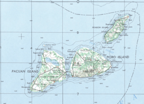
Location of municipalities of Poro and Tudela, and tourist attractions on Poro Island
Natural features:
- 1) Bukilat Cave
- 2) Busay Falls
- 3) Pangunuron Falls
- 4) Buho Rock
Beaches:
- 5) Flying Fish
- 6) Santa Rosa
Poro Island is an island in the province of Cebu, located east of Cebu Island and west of Leyte Island. Two municipalities, Poro and Tudela, are located on Poro Island. It is one of the four Camotes Islands along with Pacijan Island, Ponson Island, and Tulang Island.
Attractions
| Bukilat Cave is a large natural cavern in the southeastern part of the island. Because of naturally formed piercings in its canopy, the interior is well illuminated. There are many stalactites and stalagmites. |
| The cave served as shelter for the people living in the island from the Japanese invaders during World War II. Hidden treasures are rumoured to be scattered throughout the area. |
| There are several other less popular caves on Poro island. |
| Busay Falls |
| Pangunuron Falls |
| Buho Rock is a hole in a cliff wall said to have been formed when a Spanish warship mistook it for an enemy ship in the mist and fired cannon into it. It is reached by a stone staircase, and offers views of Poro and the sea. |
| Flying Fish |
| Santa Rosa |
This article is issued from Wikipedia - version of the 11/18/2016. The text is available under the Creative Commons Attribution/Share Alike but additional terms may apply for the media files.