Porirua Harbour
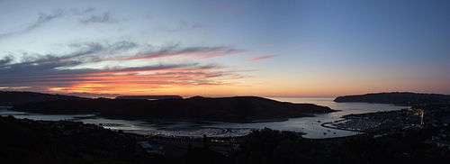
Te Awarua-o-Porirua Harbour, commonly known as Porirua Harbour, is a natural inlet in the south-western coast of the North Island of New Zealand. The city of Porirua, one of the four cities in the Wellington conurbation, surrounds it. The city centre is to the south of the harbour. The harbour has an entrance only a few hundred metres in width, close to the suburb of Plimmerton. It opens up into two arms, Porirua Inlet to the south and Pauatahanui Inlet to the north-east. Each arm is around three kilometres in length.
Part of the Porirua Inlet was reclaimed for a causeway carrying the North Island Main Trunk railway when the section between Porirua and Mana was straightened and double tracked. The new section of the Kapiti Line was opened on 7 November 1960. A new Paremata Railway Station and bridge over the entrance to the Pauatahanui Inlet were required.[1]
The line no longer followed the curves of the shoreline bays north of Porirua, and three shallow lagoons on the land side of the new causeway were created. When State Highway 1 was re-aligned and straightened in the 1970s to run alongside the rail line, these lagoons were partially filled in. Aotea Lagoon was developed into a recreational area, albeit very polluted.
The name of the harbour was officially altered to Te Awarua-o-Porirua Harbour in August 2014.[2]

Pauatahanui Inlet
The Pauatahanui Inlet arm of the harbour extends eastward to the settlement of Pauatahanui. The wetland there where the Pauatahanui Stream enters the Pauatahanui Inlet, is the largest remaining estuarine wetland in the lower North Island, and the Pauatahanui Wildlife Reserve was established in the 1980s to protect the inlet's environment and to restore damaged areas.

References
- ↑ Hoy, D.G. Rails out of the Capital (NZRLS, 1970) pp. 70,71
- ↑ "NZGB decisions". Land Information New Zealand. August 2014. Retrieved 7 November 2015.
External links
- Guardians of Pauatahanui Inlet's official page
- Pauatahanui Wildlife Reserve information page
- Porirua Harbour and Catchment Programme (from WCC)
Coordinates: 41°05′S 174°51′E / 41.083°S 174.850°E