Poquessing Creek
Poquessing Creek is a 10.3-mile-long (16.6 km) creek,[1] a right tributary of the Delaware River, that forms part of the boundary between Bucks County and the northeast section of Philadelphia, Pennsylvania. It has been part of the boundary between Bucks and Philadelphia counties since 1682.
The creek arises in Trevose and meanders to the southeast before emptying into the Delaware River. The name Poquessing comes from the Lenape "Poetquessnink," meaning "place of the mice." The mouth of the Poquessing on the Delaware was first proposed as the site for William Penn's Philadelphia, and for many years the surrounding area was known as "Old Philadelphia."[2]
The Poquessing watershed encompasses an area of approximately 21.5 square miles (56 km2), consisting of portions of Philadelphia, Montgomery, and Bucks counties, including the municipalities of Philadelphia, Upper Southampton, Lower Southampton, Lower Moreland, and Bensalem.
Poquessing Creek and its tributary streams have largely escaped the "channelization" process that has transformed other watersheds in the city. Other streams have had at least some significant portion of a tributary transformed into a storm sewer, as the map at this site discloses. This sewerization process had been used in the past to allow land to be leveled and filled in order to preserve the traditional, regular rectangular grid of streets and property lines so common to the city. By the 1930s this process was seen as creating many problems.
During the late 1950s, housing in new developments was built with curving through-streets that conformed to the natural topography, avoiding the need to fill or level the terrain. The Morrell Park neighborhood was the first in Philadelphia to follow this new pattern, avoiding for years any development near the stream valley of Byberry Creek, which flows through and about the neighborhood before its confluence with the Poquessing (though later years saw development much closer to the stream than originally envisioned). Channelization of the Poquessing affected only a tiny unnamed creek below Grant Avenue near Fluehr Park.[3]
Though Byberry Creek and its two branches, Wilsons Run and Waltons Run, remain free-flowing, their entire courses are owned and operated by the city as an integral part of the city's storm sewer system, and are so marked on city departmental maps. Despite this circumstance, they have lovely courses during low water flows.
Tributaries
- Black Lake Run
- Bloody Run
- Byberry Creek
- Colberts Run
- Elwoods Run
- Waltons Run
- Wilsons Run
Historic bridges
|
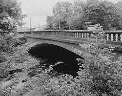
Frankford Avenue Bridge | |
|
Frankford Avenue bridge over the Poquessing Creek. | |
 | |
| Location | Philadelphia, Pennsylvania |
|---|---|
| Coordinates | 40°03′54″N 74°58′52″W / 40.0649°N 74.9811°W |
| Built | 1904 |
| Architect | John McMenamy |
| Architectural style | Other |
| MPS | Highway Bridges Owned by the Commonwealth of Pennsylvania, Department of Transportation TR |
| NRHP Reference # | 88000850[4] |
| Added to NRHP | June 22, 1988 |
Several historic bridges cross the Poquessing.
- A two-span, closed-spandrel, stone arch bridge, built in 1805, originally carried the King's Highway, later the Byberry and Bensalem Turnpike. It was improved in 1917 to carry the new Lincoln Highway but was bypassed by the Roosevelt Boulevard in 1921. It is no longer in use.[5]
- A three-span stone arch bridge, built in 1845, carrying Red Lion Road near the site of the old Red Lion Inn is still in use.[6]
- A two-span, closed-spandrel, stone arch bridge at Richlieu Road, built in 1840, is no longer in use.[7]
- A two-span, 42-ft-long, closed-spandrel, stone arch bridge at Century Lane, built in 1853 to connect the villages of Mechanicsville (now part of Philadelphia) and Elizabethtown, remains in use.[8]
- A single-span concrete arch bridge where Frankford Avenue meets Bristol Pike (both U.S. Route 13), built in 1904, is notable for its early modern use of concrete. It was listed on the National Register of Historic Places in 1988 and remains in use today.[9]
- A 19th-century four-arch stone bridge carries the Northeast Corridor rail line (originally Pennsylvania Railroad) over the Poquessing and Grant Avenue in Philadelphia.
Quotation
From The History of Philadelphia's Watersheds and Sewers compiled by Adam Levine, Historical Consultant. Philadelphia Water Department:
- Poquessing Creek rises in Montgomery County, crosses the north-west line of the late township of Byberry, where it receives a branch which flowed mainly through Moreland. It there bends northward into the county of Bucks, again southward, when it touches the township line, and flows south-east and south-west, forming the boundary line of Byberry, and turning to the south-east enters the Delaware.—Bloody run empties into it at Carter's mill, Black Lake creek at Mechanicsville, and Gilbert's run about a mile below.—Elwood's run and Wilson's run, which rise in Byberry township, unite to form Byberry creek, which enters the Poquessing near the Red Lion tavern.—Colbert's run and Walton's run unite and form Walton's creek, which flows into the Byberry. The latter meets the Poquessing within a mile of where it enters the Delaware River. On Lindstrom's map this stream is called Pouquessinge, La Riviere de Kakimon's. Mr. Henry defines Kakamon's to be a name for the pike, so that this was Pike creek; but Peder Lindstrom also has upon his map Drake Kylen, La Riviere des Dragons, or Dragon River. Johan Campanius calls it Drake Kylen. In a patent to Nicholas Moore it is called Poetquessingh, and on Holmes' map, Potquessin.[10]
See also
References
- ↑ U.S. Geological Survey. National Hydrography Dataset high-resolution flowline data. The National Map, accessed April 1, 2011
- ↑ "Destruction of an Historical Relic, The "Old Bake-house" on the Delaware Burned, New York Times, Dec. 10, 1865.
- ↑ Map showing sewerized tributary at MapTech.com
- ↑ National Park Service (2007-01-23). "National Register Information System". National Register of Historic Places. National Park Service.
- ↑ Old Lincoln Highway Bridge at BridgeHunter.com
- ↑ Red Lion Road Bridge at BridgeHunter.com
- ↑ Richlieu Road Bridge at BridgeHunter.com
- ↑ Century Lane Bridge at BridgeHunter.com
- ↑ Frankford Avenue Bridge at BridgeHunter.com
- ↑ Changes in the Names of Streams In and About Philadelphia ("Public Ledger Almanac: 1879". Pages 3, 5, 7, 9, 11, & 13)
External links
- U.S. Geological Survey: PA stream gauging stations
- A photograph of Poquessing Creek from Windows Live Local, after flowing under I-95 and just before emptying into the Delaware River.
- Listing of the Frankford Avenue Bridge at Philadelphia Architects and Buildings
- Listing and photographs of the Frankford Avenue Bridge at the Historic American Engineering Record
Coordinates: 40°03′09″N 74°58′42″W / 40.0524°N 74.9782°W