Pontic Mountains
| Pontic Mountains | |
|---|---|
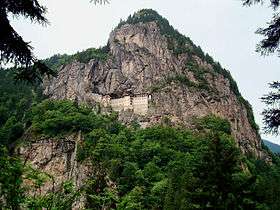 Sümela Monastery on the Pontic Mountains | |
| Highest point | |
| Peak | Kaçkar Dağı |
| Elevation | 3,937 m (12,917 ft) |
| Coordinates | 40°50′N 41°09′E / 40.833°N 41.150°E |
| Dimensions | |
| Length | 1,000 km (620 mi) |
| Geography | |
| Countries | Turkey and Georgia |
| Range coordinates | 40°30′N 40°30′E / 40.5°N 40.5°ECoordinates: 40°30′N 40°30′E / 40.5°N 40.5°E |
The Pontic Mountains or Pontic Alps (Turkish: Kuzey Anadolu Dağları, meaning North Anatolian Mountains) form a mountain range in northern Anatolia, Turkey. They are also known as the Parhar Mountains in the local Turkish and Pontic Greek languages. The term Parhar originates from a Hittite word meaning "high" or "summit".[1] In antiquity, the mountains were called the Paryadres[2] or Parihedri Mountains.[3]
Geography
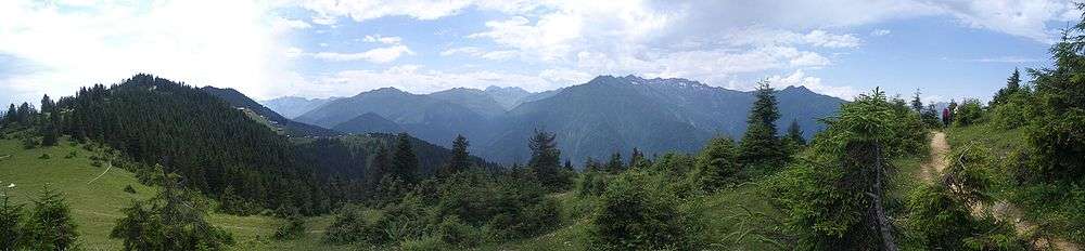
The range runs roughly east-west, parallel and close to the southern coast of the Black Sea. It extends northeast into Georgia, and west into the Sea of Marmara, with the northwestern spur of the Küre Mountains (and their western extension the Akçakoca Mountains) and the Bolu Mountains, following the coast. The highest peak in the range is Kaçkar Dağı, which rises to 3,937 m (12,917 ft). The North Anatolian Fault and the Northeast Anatolian Fault, which are east-west running strike-slip faults, run along the length of the range.
Ecology
The mountains are generally covered by dense forests, predominantly of conifers. The Northern Anatolian conifer and deciduous forests is an ecoregion which covers most of the range, while the Caucasus mixed forests extend across the far-eastern end of the range, known as the Kaçkar Mountains. The region is home to Eurasian wildlife such as the Eurasian sparrowhawk, golden eagle, eastern imperial eagle, lesser spotted eagle, Caucasian black grouse, red-fronted serin, and wallcreeper.[4] The narrow coastal strip between the mountains and the Black Sea, known as Pontus, is home to the Euxine-Colchic deciduous forests, which contain some of the world's few temperate rainforests. The Anatolian Plateau, which lies south of the range, has a considerably drier and more continental climate than the humid and mild coast.[5]
References
- ↑ Karadeniz Ansiklopedik Sözlük. See the "Parhar" (plateau) and "Parhal" (village) articles.
- ↑ Strabo (23). "XI". Geography. p. xii.4. Check date values in:
|date=(help) - ↑ Pliny, the Elder (77-79). "VI". Natural History. p. iix.25. Check date values in:
|date=(help) - ↑ Couzens, Dominic (2008). Top 100 Birding Sites of the World. University of California Press. pp. 73–75. ISBN 978-0-520-25932-4.
- ↑ Pontic Mountains and highlands