Ponte di Legno
| Ponte di Legno | |
|---|---|
| Comune | |
| Comune di Ponte di Legno | |
 | |
 | |
 Ponte di Legno Location of Ponte di Legno in Italy | |
| Coordinates: 46°15′34″N 10°30′34″E / 46.25944°N 10.50944°ECoordinates: 46°15′34″N 10°30′34″E / 46.25944°N 10.50944°E | |
| Country | Italy |
| Region | Lombardy |
| Province / Metropolitan city | Province of Brescia (BS) |
| Frazioni | Poia, Zoanno, Precasaglio, Passo del Tonale, S.Apollonia, Pezzo |
| Government | |
| • Mayor | Mario Giuseppe Bezzi |
| Area | |
| • Total | 100.1 km2 (38.6 sq mi) |
| Elevation | 1,258 m (4,127 ft) |
| Population (2011)[1] | |
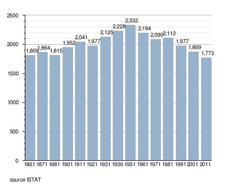
| • Total | 1,773 |
| • Density | 18/km2 (46/sq mi) |
| Demonym(s) | Dalignesi |
| Time zone | CET (UTC+1) |
| • Summer (DST) | CEST (UTC+2) |
| Postal code | 25056 |
| Dialing code | 0364 |
| Website | Official website |
Ponte di Legno (Pònt in the Camunian dialect) is an Italian comune of 1,773 inhabitants[1] in Val Camonica, province of Brescia, in Lombardy.
Geography
Situated at the confluence of the two source rivers of the Oglio, Ponte di Legno is the uppermost comune of Valle Camonica.
History
The territory of the municipality of Ponte di Legno was part of the ancient Dalaunia (Dalegno), which included also the comune of Temù.
On September 27, 1917 the village was bombarded by Austrian cannons and razed to the ground in a short time.
Monuments and places of interest

Religious architectures
The churches of Ponte di Legno are:
- Parish of the Holy Trinity, dated 1685, though the wooden door is from 1929. Inside there are works from the workshop of Ramus.
- Church St. Appollonio in Plampezzo. It is an ancient church dating from the twelfth century, with frescoes of the thirteenth century of the hand of the painter Johannes from Volpino.
Society
Demographic trends
Traditions and folklore
The scütüm are in camunian dialect nicknames, sometimes personal, elsewhere showing the characteristic features of a community. The ones which characterize the people of the comune are:
- Poia: Bòrse
- Zoanno: Gòs
- Pezzo: Benui
- Precasaglio: Berlif
Twin towns
Ponte di Legno is twinned with:
-
 Recco, Italy
References
External links
| Wikimedia Commons has media related to Ponte di Legno. |
- (Italian) Historical photos - Intercam
- (Italian) Historical photos - Lombardia Beni Culturali