Saint-Nazaire Bridge
| Saint-Nazaire Bridge | |
|---|---|
 | |
| Coordinates | 47°16′43″N 2°09′57″W / 47.278603°N 2.165881°WCoordinates: 47°16′43″N 2°09′57″W / 47.278603°N 2.165881°W |
| Carries | Cars, pedestrians and cycles |
| Crosses | Loire river |
| Locale | Saint-Nazaire |
| Official name | Pont de Saint-Nazaire |
| Maintained by | Conseil général de la Loire-Atlantique |
| Characteristics | |
| Design | Cable-stayed bridge |
| Total length | 3,356 m |
| Longest span | 404 m |
| History | |
| Opened | 1975 (built in 1974) |
| Statistics | |
| Toll | Free |
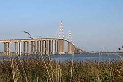
The Saint-Nazaire Bridge (French: Le pont de Saint-Nazaire) is a cable-stayed bridge spanning the Loire river and linking Saint-Nazaire on the north bank and Saint-Brevin-les-Pins on the south bank, in the department of Loire-Atlantique, Brittany, France.The bridge is crossed by the « Route bleue » (RD213).
The cable-stayed metallic structure measures 720 meters, and, including the access viaducts, represents a total length of 3 356 meters.
History
The Saint-Nazaire Bridge was commissioned on October 18, 1975 after three years of construction. With its 404-meter central span, the 720-meter metal structure held, at the time of its construction, the world record length for a cable-stayed metallic bridge.
In 1992, the Loire-Atlantique general council took over the Saint-Nazaire SAEM, the contractor for the creation and operation of the bridge. Access to the bridge became toll-free on October 1, 1994.
The building was remitted to the Loire-Atlantique’s general council road heritage organization, which is responsible for its management and maintenance since August 1, 1995. Since its creation, trading between the north and south shores of the estuary have improved considerably.
At the time of its construction in 1975, the Saint-Nazaire bridge was the longest one ever built in France. Moreover, it held the world record for the longest cable-stayed bridge for eight years.
Construction and specifications
The bridge consists of two access viaducts made out of prestressed concrete: the northern viaduct is 1 115 m long, and the southern one is 1521 m long. The main structure is composed of a 720 m long cable-stayed metallic frame. It is crossed by the department road RD2132.
The construction of the bridge was entrusted to a consortium of companies:
- Metallic construction : Compagnie Française d’Entreprises Métalliques (CFEM) ;
- Concrete structures: Société Générale d’Entreprises (SGE) (the foundations were subcontracted to the Morillon-Corvol, Courbot and Dodin companies).
Traffic rules and regulations
The speed is limited to 70km/h. The crossing may be restricted to certain vehicles, if not all, during strong wind periods (as little as 80km/h for cyclists).
The general council has implemented a lane management system for the bridge (reversible lanes) which, throughout the day or depending on punctual events, allows for a second lane to be dedicated to the busiest direction. This system results in folding barriers, illuminated red studs embedded in the asphalt and road sign frames allowing for illuminated road signs (green arrow/orange or red cross) to indicate the direction assigned to each of the three lanes.
Unique in France, this system went live on August 25, 2010 and is regarded as « experimental ». In fact, it is a requirement set by the state services since the traffic code mandates white markings on the ground. The Loire-Atlantique general council has, therefore, received a 1 year permit, renewed every year since then.
However, two elements are in need of improvement:
- The illuminated beacons due to the LEDs being too fragile ;
- Increased traffic during the summer season which, despite this new system, causes numerous traffic jams.
In order to offer an alternative way of crossing the river for pedestrians and cyclists during summer time (May to September), in June 2010, the general council had contemplated implementing a river shuttle service between Saint-Nazaire and Mindin. Considering its prohibitive cost, the project was permanently dropped in December 2011.
The only regular coach lines using the bridge and providing intercity connections between Saint-Nazaire and the Pays de Retz region are those of the Lila network (lines 15, 16 and 17). The line 17 vehicles are fitted with eight bicycle-only spaces.