Pont de Neuilly (Paris Métro)
Pont de Neuilly | |||||||||||
|---|---|---|---|---|---|---|---|---|---|---|---|
| Paris Métro station | |||||||||||
.jpg) | |||||||||||
| Location |
185, av. Charles de Gaulle 205, av. Charles de Gaulle 209, av. Charles de Gaulle Neuilly-sur-Seine Île-de-France France | ||||||||||
| Coordinates | 48°53′06″N 2°15′35″E / 48.88500°N 2.25972°ECoordinates: 48°53′06″N 2°15′35″E / 48.88500°N 2.25972°E | ||||||||||
| Owned by | RATP | ||||||||||
| Operated by | RATP | ||||||||||
| Other information | |||||||||||
| Fare zone | 2 | ||||||||||
| History | |||||||||||
| Opened | 29 April 1937 | ||||||||||
| Services | |||||||||||
| |||||||||||
| Location | |||||||||||
 Pont de Neuilly Location within Paris | |||||||||||
Pont de Neuilly is a station on Paris Métro Line 1, situated in the prosperous suburban commune of Neuilly-sur-Seine. Between 1940 and 1950 it was known as Pont de Neuilly, Avenue de Madrid.
It is named after the Pont de Neuilly, a nearby bridge. The bridge - which carries parallel road and rail links between Neuilly and La Défense, over the river Seine - is in fact nearer to the Esplanade de la Défense station than to the Pont de Neuilly station.
It was the western terminus of Line 1 from 1937 until 1992, when the western extension to La Défense was opened. Above the station lies an esplanade from which one can see the area of La Défense.
Station layout
| Street Level |
| B1 | Mezzanine for platform connection |
| B2 Platforms |
||
| Westbound | ← | |
| Eastbound | | |
Gallery
.jpg) Eastbound view
Eastbound view.jpg) Westbound view
Westbound view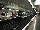 MP 89 rolling stock arrving at Pont de Neuilly
| Wikimedia Commons has media related to Pont de Neuilly (Paris Metro). |
References
- Roland, Gérard (2003). Stations de métro. D’Abbesses à Wagram. Éditions Bonneton.
This article is issued from Wikipedia - version of the 11/18/2016. The text is available under the Creative Commons Attribution/Share Alike but additional terms may apply for the media files.