Polish National-Territorial Region
| Polish National-Territorial Region Polski Kraj Narodowo-Terytorialny | |||||
| Autonomous region of the Republic of Lithuania | |||||
| |||||
|
Flag | |||||
| Anthem Rota | |||||
 | |||||
| Capital | Naujoji Vilnia (Nowa Wilejka) | ||||
| History | |||||
| • | Self-proclaimed autonomy | 6 September 1990 | |||
| • | Local councils suspended | 3 September 1991 | |||
| Area | |||||
| • | 1990 | 4,930 km2 (1,903 sq mi) | |||
| Population | |||||
| • | 1990 | 215,000 | |||
| Density | 43.6 /km2 (113 /sq mi) | ||||

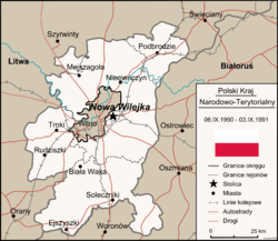
The Polish National-Territorial Region (Polish: Polski Kraj Narodowo-Terytorialny) was an autonomous region in Lithuania, self-proclaimed by the local Poles on 6 September 1990. The region included areas surrounding Vilnius (Polish: Wilno), capital of Lithuania, where Poles formed the majority (60–90%),[1] This Eastern part of Lithuania had been part of Poland (from 1922) before being attached to Lithuania under the Mutual Assistance Treaty with the Soviet Union in 1939. The autonomy region with capital in Naujoji Vilnia (Polish: Nowa Wilejka) included 4,930 km² and population of 215,000 (66% of them were Poles and 34% in Naujoji Vilnia[2]). The Polish autonomist movement (the leaders of which included Jan Ciechanowicz) was related to the Yedinstvo movement and had tacit support from Moscow (thus, when following the Act of the Re-Establishment of the State of Lithuania the Soviets applied a blockade against Lithuania, the areas of Eastern Lithuania with significant minority population were mostly spared of the blockade, with the aim of gaining minorities' support for Moscow). In the region, the Polish Red-and-White flags were used as official flag and Rota was used as an anthem in the region.
The Lithuanian government declared the formation of the Polish autonomous district in Lithuania unconstitutional. After the August Coup of the Soviet hardliners had failed, the Lithuanian parliament suspended on 3 September 1991 the democratically elected local councils that had sought autonomy or secession from Lithuania.[3]
See also
- Polish minority in Lithuania
- Republic of Central Lithuania
- Vilnius Region
- Ethnic history of the Vilnius region
References
- ↑ at the official website of Vilnius Regional Statistical Office
- ↑ at the official website of Vilnius Regional Statistical Office
- ↑ Horne, Winston A. Van (1997). Global convulsions: race, ethnicity, and nationalism at the end of the twentieth century. SUNY Press. pp. 253–254. ISBN 0-7914-3235-1.
Coordinates: 54°42′N 25°25′E / 54.700°N 25.417°E