Polish–Soviet border agreement of August 1945
| Territorial evolution of Poland in the 20th century |
|---|
|
Post World War II |
|
Areas
|
|
Demarcation lines
|
|
Adjacent countries |
The Border Agreement between Poland and the USSR of 16 August 1945 established the borders between the Union of Soviet Socialist Republics (USSR) and the Republic of Poland. It was signed by the Provisional Government of National Unity (Tymczasowy Rząd Jedności Narodowej) formed by the Polish communists. According to the treaty, Poland officially accepted the ceding its pre-war Eastern territory to the USSR (Kresy) which was decided earlier in Yalta already. Some of the territory along the Curzon line, established by Stalin during the course of the war, was returned to Poland. The treaty also recognised the division of the former German East Prussia and ultimately approved the finalised delimitation line between the Soviet Union and Poland: from the Baltic sea, to the border tripoint with Czechoslovakia in the Carpathians.[1][2][3]
Prelude
Prior to the First World War, within the Russian Empire Polish territories were administered by a Vistula Land, whose eastern frontier roughly determined the ethnic border between the Polish people on the west, and the Ukrainians and Belarusians (the referred to as Little and White Russians respectively) on the east. In Austrian Galicia there was no administrative border which marked the ethnic one the Polish and the Galician Ukrainians (Ruthenians).
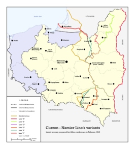
During the First World War, the Russian Civil, the Polish-Soviet and Polish-Ukrainian wars, the territory passed hands several times, and each of the controlling powers tried to create its own administration on the region. During the conflict, the Supreme War Council, tried several times to intervene and create an agreeable border between the Second Polish Republic and Bolshevik Russia, the most notable outcome, was the border presented by the British Foreign Secretary George Curzon, after whom the proposed line was named. The line mostly followed the 19th century border between the Vistula Land, but also extended further south and portioned Galicia along the rough ethnic border between Poles and Ukrainians.
Though accepted by the Bolshevik government, the line was ignored by Poland, and after the Polish-Soviet War's conclusion, on the Treaty of Riga, Bolshevik Russia recognised a new border almost 250 km east of the Curzon Line. The border was recognised by the League of Nations in 1923, and confirmed by numerous Polish-Soviet treaties and delimited in due course.
World War II partitions
The Molotov-Ribbentrop Pact of August 1939 provided for the partition of the Second Polish Republic between the USSR and Nazi Germany. Following the corresponding invasions, a new border was drawn up, though based on the Curzon Line, deviated west of it in several regions. Most notably, was the Belastok Voblast, that was added to the Byelorussian Soviet Socialist Republic, although most of the region was populated by Poles.
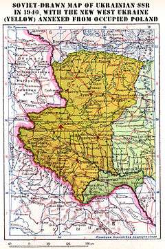
After Germany's invasion of the USSR, the territory in question was also re-partitioned by the Nazis. Ukraine and Belarus were administered by the occupation Ostland and Reichskommissariat Ukraine Reichskommissariats. Galician territory east of the 1939 border and the Belastok Voblast plus adjacent territory to the east of this were transformed respectively into the Distrikt Galizien and Bezirk Bialystok, and subjugated directly to the Reich.
Following the Soviet Union's liberation of Ukraine and Belarus, in 1943/1944 the Tehran conference and Yalta conference discussed upon the future of the Polish-Soviet borders, and the Allied leaders recognised the Soviet right to the territory east of the 1939 border. However, after the liberation of Western Ukraine and Belarus in summer of 1944, a Polish committee formed in the town of Sapotskin sent a letter to Moscow asking that they remain part of Poland. Stalin agreed, and on 29th of September, administration of 17 (of the 23) districts of Belastok Voblast (including the city of Białystok) and an additional three (Siemiatycze, Hajnówka and Kleszczele) of the Brest Voblast was passed to the Polish Committee of National Liberation from the BSSR.
In October 1944 these were joined by a further transfer of Lubaczów, Horyniec, Laszki, Uhnów and Sieniawa raions of the Lviv Oblast from the Ukrainian Soviet Socialist Republic. In March 1945, an additional batch of land, the Bieszczady, Lesko, and most of Przemyśl raions(including Przemyśl city) were transferred to Poland from the Drohobych Oblast of Ukraine to the now Provisional Government of the Republic of Poland.
Soon afterwards World War II finished, and as the Provisional Government continued to transfer administration from military to civil bodies, it also finalised its new borders with its neighbours, and in particular, the Soviet Union. On 16th of August 1945, the border agreement was officially signed by Edward Osóbka-Morawski, on behalf of the Provisional Government of National Unity and Vyacheslav Molotov, the Soviet Minister of Foreign affairs. The exchange of ratified documents occurred on 5 February 1946 in Warsaw, and from that date the agreement was in force.
Aftermath
Although the treaty finalised the 1939 line, with the 1944/45 adjustments, the border would receive a few more alterations. On 15th of May 1948, the raion of Medyka was transferred from the Drohobych Oblast of Ukraine to the Republic of Poland. And finally a 1951 Polish–Soviet territorial exchange, saw Poland return its pre-1939 territory of Ustrzyki Dolne raion from the Drohobych Oblast, and instead it passed the USSR part of the Lublin Voivodship, with the cities of Belz, Uhniv, Chervonohrad and Varyazh, (all of which after the Nazi & Soviet Axis invasion of Poland in September 1939 became a part of Poland occupied by the USSR and was allocated to Ukraine in 1939 until 1941 when the Nazis invaded the Soviet Union. It was occupied again in 1944-1945 after the Soviet advance to Berlin). The border between Poland and Belarus, and Poland and Ukraine has remained the same since.
References
| Polish Wikisource has original text related to this article: |
- ↑ Sylwester Fertacz, "Krojenie mapy Polski: Bolesna granica" (Carving of Poland's map). Alfa. Retrieved from the Internet Archive on 14 November 2011.
- ↑ J.A.S. Grenville, The major international treaties, 1914–1973. A history with guide and text. Taylor & Francis. 572 pages.
- ↑ Pro-rector Bogdan Kawałko, "Prostowanie granicy" (The fixing of border). Dziennik Wschodni, 2006-02-03. Wyższa Szkoła Zarządzania i Administracji w Zamościu. Retrieved 15 November 2011.