Point Reyes


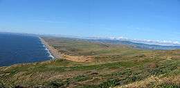
Point Reyes is a prominent cape and popular Northern California tourist destination on the Pacific coast of northern California. It is located in Marin County approximately 30 miles (50 km) west-northwest of San Francisco. The term is often applied to the Point Reyes Peninsula, the region bounded by Tomales Bay on the northeast and Bolinas Lagoon on the southeast. The headland is protected as part of Point Reyes National Seashore.
Overview
The cape protects Drakes Bay on its southern side. The headland is largely drained by Drakes Estero. Drakes Bay and Drake's Estero are named after English seafarer Sir Francis Drake who possibly hauled his ship, the Golden Hinde, up onto the beach for repairs in June 1579. Inverness Ridge runs along the peninsula's northwest-southeast spine, with forested peaks around 430 meters (1,400 ft). West of the ridge, the land flattens out and the vegetation turns to scrub. The Mount Vision fire in 1995 burned part of Inverness Ridge.
Point Reyes lends its name to the town of Point Reyes Station, California.
The point may once have been known as Lobes Lighthouse by the sailors of clipper ships on the meat trade.[1] (Lobes are ridges of slide material commonly referred in the literature from erosion events and the point is of that shape out to sea).
History
On 13 November, Spanish explorer Juan Rodríguez Cabrillo sighted and named "Cabo de Pinos" (Point Reyes), but missed the entrance to San Francisco Bay, a lapse that mariners would repeat for the next two centuries and more, due to the fog that characterizes the area. The Spanish explorer Sebastián Vizcaíno named the land Punto de los Reyes ("Kings' Point") when his ship, the Capitana anchored in Drakes Bay on the Day of the Three Kings (Epiphany, or the end of the 12 Days of Christmas) on January 6, 1603.[2]
The Coast Miwok
Point Reyes' first inhabitants, the Coast Miwok, lived on the land for thousands of years.[3] They left evidence of well over a hundred encampments on the peninsula, with a population estimated to have been nearly 3,000. Seasonal hunters and gatherers, rather than cultivators, they were nourished by fish, clams, mussels, and crab, in addition to the deer, elk, bear, mud hen, geese, and small game they hunted with spears and bows. Although they did not cultivate the land, they used the plentiful acorns as a staple part of their diet by removing the tannic acid and making a pulp that was stored in dry granaries.
Although the exact location of Sir Francis Drake's 1579 anchorage at Point Reyes is still being debated, evidence has confirmed that he landed near a Coast Miwok settlement. Observations, presumably written by his chaplain, describe the genial welcome Drake and his men received, complete with ceremony and gifts. The Coast Miwok continued their peaceful existence until late in the 18th century when the Spanish built Mission San Rafael and padres began journeying to Point Reyes to recruit them to move to the mission. While attempting to convert them, these padres disrupted their traditional way of life in addition to inadvertently introducing diseases that brought untimely deaths, fewer births, and significantly increasing infant mortality rates.
In 1992, Coast Miwok descendants established the Federated Indians of Graton Rancheria and, by 2001, had 400 members who could prove their descent from local tribes. Today, they enjoy a rebirth of traditional customs and ceremonies, often held in Kule Loklo, "Valley of the Bear", a replica Miwok village in Point Reyes National Seashore.[4]
Sir Francis Drake

Although early explorers and Spanish trading galleons journeying between the Philippines and Acapulco passed by Point Reyes, some even anchoring briefly, it is the landing by Sir Francis Drake that dominates discussion of this era of Point Reyes early history. The exact location of his landing, significant as the first European landing in Northern California, has sparked countless hours of spirited debate spanning four centuries. Experts agree, however, that he landed somewhere near the area on June 17, 1579 and proclaimed it Nova Albion (New England). Most likely, as validated by a National Historic Landmark designation, the precise place of Drake's landing is Drake's Cove at Point Reyes National Seashore.[5]
The wreck of the San Augustin

Rumors of Drake's discovery of a safe harbor on the California coast intrigued the Spanish. Their trade between the Philippines and Mexico was booming, and they were constantly seeking safe harbors along their route. Many believe that Drake's discovery of such a harbor inspired the Spanish to order Sebastian Rodriguez Cermeno, a Portuguese captain trading for Spain, to survey the California coast on his journey to Mexico from the Philippines in 1595. Commanding the San Augustin, a Manilla galleon laden with a luxury cargo of Chinese silks, spices, and Ming porcelain bound for Acapulco, Cermeno endured both the first of hundreds of documented shipwrecks at Point Reyes, as well as one of the most amazing journeys to safety.
Struggling with a decrepit, heavily-laden ship and a tired, rebellious crew that wanted to go home, Cermeno explored the California coast, eventually anchoring near the Point Reyes inlet now called Drakes Estero. Within a few days, a November storm beached the ship where it listed and was relentlessly pounded by the furious surf. It soon broke apart, killing several men and dumping the precious cargo, some of which was eventually collected, and used, by local Coast Miwok tribesmen.
Cermeno salvaged a small, open launch, likened to a large canoe, and loaded it with the 70 surviving crew members to begin the long journey home. After a grueling two-month voyage, remembered as a remarkable feat of seamanship, Cermeno and all crew arrived safely in Acapulco in January 1596. Despite his amazing journey, Cermeno received no celebratory welcome, for he had not only lost his ship and cargo, but had also failed to locate the safe harbor he was ordered to find.[6]
Portolá's inland expedition and the establishment of missions
Despite reports of a lovely land populated by friendly tribes, Spain neglected California until the second half of the 18th century. By that time, trade had become an important source of income, and it was becoming clear that the nation controlling California's harbors would reap incredible profits. When England, France, and Russia began to covet California's coast, the King of Spain knew it was time to fortify it. To identify sites for presidios and missions, an overland expedition of 67 men and 100 pack mules left San Diego in 1769. Led by Gaspar de Portolá, the governor of Baja California, they began walking to the largest known harbor, Monterey Bay. Portolá expected more of a harbor than what they found at Monterey, and decided they must not have reached it yet. Pushing on north along the coast, they instead discovered San Francisco Bay. Prior to that, from a high point on the coast south of Pacifica, they saw and recognized (from the description of Manila Galleon pilot Cabrera Bueno) Point Reyes and the Farallon Islands.[7] The expedition was blocked from going farther north toward Point Reyes by the Golden Gate and San Francisco Bay, since they had no boats.
Beginning with Portolá's expedition, Spain began establishing presidios and missions. By 1817, Mission San Rafael was established and padres began journeying to Point Reyes, intent on enticing the Coast Miwok to the mission. Although they were successful in convincing many to settle at the mission to begin a life of backbreaking labor, it was soon clear that the Coast Miwoks were not thriving. Serious outbreaks of smallpox and pneumonia killed many. Those who survived sickened from a wide variety of other illnesses, such as colds and measles. Birth rates dropped, and mortality rates increased at an alarming rate. Since the missions depended upon healthy workers for their prosperity, these illnesses foretold their demise.
Mexico gained independence from Spain and possession of California in 1821. The deterioration of Mission San Rafael accelerated when secularization of the missions by Mexico in 1834 ended the era of mission domination that had destroyed the self-sufficient, centuries-old Coast Miwok way of life. Most mission land was subdivided and into large land grants used mainly for cattle ranching. Being mostly unsuitable for cattle, Point Reyes itself and Drake's Bay became part of Rancho Punta de los Reyes Sobrante (Sobrante means "leftover") in 1843.[8] This was only a few years before cession of California to the United States, which led to decades of confusion and boundary battles.[6]
Rancho Tomales y Baulines
When the Spanish missions in California were dismantled, virtually all of Point Reyes was given to Rafael Garcia, a corporal in the Mexican Army, who was awarded two leagues (8911 acres) in March 1836. Named Rancho Tomales y Baulines, it is believed to have included the entire Olema Valley from Tomales Bay to Bolinas Lagoon, although its borders were never clearly defined. Garcia's failure to survey and confirm boundaries, as required by Mexican law, set the stage for confusion and lengthy court battles when the rancho was dissolved.
Unlike many rancheros, Garcia obeyed the law by actually living there. He built a wood and thatch home near today's National Seashore Bear Valley Headquarters and soon had a comfortable home for his family as well as headquarters for his extensive ranching operation consisting of approximately 3,000 cattle, 400 horses, and large herds of sheep and hogs. Thriving quickly, the rancho was soon largely self-sufficient. Grains and produce were grown, and a wild steer was slaughtered each day to provide the staple diet of tortillas and beefsteak. Additionally, wool was processed and woven for clothing, and hides were crafted into a wide variety of leather products, including shoes and saddles. To acquire luxury items he could not produce, Garcia, like most coastal rancheros, traded hides, tallow, and produce to smugglers. As a result, his rancho was adorned with bronze candlesticks, fine candles, artificial flowers, framed engravings, and elegant furniture. He also enjoyed seemingly unlimited supplies of wine and champagne. Although it is likely Garcia got most of his luxury items from smugglers, he may have obtained some of them from another source - Point Reyes' many shipwrecks.
When Mexico lost California to the United States, Garcia continued to prosper for a while. Soon after the American takeover, the 1849 Gold Rush brought floods of prospectors. Where his wild cattle had been valued only for hides and tallow, he could now sell them to feed hungry gold-seekers, netting as much as $35 each. Unfortunately for Garcia, these gold-rich years ended quickly: in 1851, the United States passed a law requiring rancheros to prove legal ownership of their land grants. While the Garcias continued ranching, their land began to disappear until, after 15 years of litigation, multiple court appearances, and high legal fees, Garcia had sold all but 3085 acres of his grant at bargain basement prices.[6]
Confused boundaries
Although Garcia believed he owned virtually all of Point Reyes, another Point Reyes land grant was awarded the same year, 1836. It was given to an Irishman James Berry who had become a Mexican citizen and colonel in the army. This land grant was also in the Olema Valley, and, to add to the boundary confusion, he soon left the area and hired Garcia to oversee it. A mere two years later Berry sold nearly 9,000 acres of it to a sea captain, Joseph Snook, an act clearly prohibited by Mexican law and grounds for forfeiture of the entire grant. Although Berry understandably wanted to keep the sale secret, Snook wanted legal title. He discovered that the only way he could obtain legal title of the land he had illegally purchased was to formally denounce Berry's ownership on the grounds that he had never occupied it. He was successful and gained legal title to the land he had illegally purchased, stocked it with 56 head of cattle, and, like Berry, hired Garcia to oversee it. Three months after he won legal title, he illegally sold it.
And began a confusing series of sales and transfers that no one seemed to be able to untangle. Finally, in 1844, the rancheros themselves asked the Mexican government to investigate titles and clarify ownership. Little was clarified, and it was not until the United States took possession of California and required rancheros to conduct surveys and make court appearances to retain their land that the confusing pattern of sales and trades were untangled. Most rancheros were eventually able to prove ownership. Unfortunately, by this time, they had run out of cash and were forced to sell to pay the survey and daunting legal fees. Entrepreneurial Americans were delighted to capitalize on the opportunity. With cash in hand, they purchased these huge Mexican land grants, often paying less than $2 per acre, thus beginning Point Reyes's next chapter as a dairying empire.[6]
The Shafter Empire
Settlement patterns at Point Reyes were forever changed when the Shafters acquired it. Lords of Point Reyes for decades, the Shafter Brothers, Oscar and James, and son-in-law Charles Webb Howard, established large-scale, high-quality dairies that became prime examples of cleanliness, organization, and success. 13 of the 31 dairies they established still thrive today.
Oscar was the first to arrive. A Vermont lawyer intent upon making his fortune and returning home as soon as possible, he left his family to journey to booming San Francisco. His separation from them became intolerable when his two youngest children died while he was away. Still not willing to give up the promise of wealth, he convinced his wife to come, bringing their surviving daughter. They thrived, and Oscar fathered four more California-born daughters. Oscar soon convinced his younger brother, James, also a lawyer, to join him. They became known as San Francisco's foremost authorities on title litigation. Using their title expertise, they began acquiring Point Reyes land. When Oscar's oldest daughter married Charles Webb Howard, also a lawyer, the trio partnered to transform windswept Point Reyes into prosperous dairies.
Determined to supply booming San Francisco with its butter, by 1857, the partners began fencing huge expanses of land (eventually resulting in 40 miles of fencing), building homes and barns, and stocking the dairies with the finest pure-bred bulls and rams, some costing over $1,400. By 1868, they had 3,500 cows on 17 dairies and were producing over 700,000 pounds of butter a year. All their dairies were operated by renters. When the most industrious of these renters tried to buy the dairy they worked, they failed. Many eventually left, establishing some of California's major dairies.
Despite their boundless optimism about the promise of Point Reyes, they did not get rich from it. Although they lived the opulent lifestyles of the wealthy of San Francisco, they were plagued by financial worries. Their children tried to hold on to the dairies, trying unsuccessfully to stop their decline despite aging ranches, sickening herds, and often unhappy tenants. Finally, in 1937, an era ended when the last of the Shafter Empire was sold, ushering in a new parade of owners.[6]
The towns of Point Reyes
Four towns comprise the communities of Point Reyes: Bolinas, Olema, Inverness, and Point Reyes Station. For centuries, Bolinas' remote lagoon made it the perfect secret harbor. Although it is not so documented, it is likely that the 1808 Russian expedition to Bodega Bay that nearly wiped out the local otters and fur seals hunted in Bolinas Lagoon. During Spanish and Mexican rule, this remote lagoon was used by American, British, and Russian smugglers intent on avoiding tariffs and regulations. Later, when the Gold Rush of 1849 generated a huge market for lumber, Bolinas became the port for nearby timber operations and, briefly, quarrying limestone. By the late 1960s, Bolinas had become home to a large community of idealistic hippies, many of whom had left San Francisco's Haight-Ashbury for a less populated paradise. In 1971, they succeeded in scrapping a master plan calling for a population of 28,000 by imposing a moratorium on new homes and defeating efforts to widen its access highway. Instead, a plan was approved that made agriculture, fishing, and small business the town's economic base. Bolinas soon gained renown for its unusual structures and recreational drug use, illustrating disregard for building codes and drug laws. Although those days are gone, Bolinas remains a unique corner of this magnificent peninsula with some residents who continue to tear down road signs in hope tourists will not find it.

As soon as the Shafter dairies began to thrive, it became evident that Point Reyes needed a centrally-located town for supplies, services, and entertainment. In 1857, a hotel and saloon were built and the young town was named "Olema", meaning "coyote" in the Coast Miwok dialect. Within three years, it had emerged as the region's commercial center with a post office, grocery store, saloon, butcher, livery stable, and two hotels. By 1867, a wagon road from San Rafael was built and a stage coach arrived twice a week. It soon gained the reputation as a great place to drink. To combat this reputation, Druids Hall was completed in 1885. While this Olema chapter of the United Ancient Order of Druids adhered to principles of mutual support, intellectual growth, and social consciousness, it also served as a temperance society. Virtually deserted when the railroad stopped at Point Reyes Station instead of Olema, it languished until the 1960s when millions of visitors began coming to the adjacent Point Reyes National Seashore.
Inverness remains a small community of charming cottages, lovely gardens, and uncontested streets amid a stunning setting. It exudes an aura of a village of yesteryear, populated with modern residents who are clearly aware of their good fortune to live there.
The Shafters lobbied hard for a railroad to serve Point Reyes. When it was finally built, it bypassed Olema, terminating, instead, two miles away. When the first train arrived early in 1875, Point Reyes Station was a cow pasture. Passengers were not happy to be dropped there with no services to accommodate them, and it was soon clear that a town must be built. By 1880, it had a hotel, saloon, blacksmith shop, livery stable, butcher shop, and school. Its post office was completed in 1882, and its first store opened in 1883. When the railroad era ended, growth was slow. It was not until after World War II that a medical center and an impressive shopping center, including a drugstore, dentist, coffee shop, and library, had been completed. The train station became the local post office, while the former engine house was converted into a community center. In the 1970s, hippies established cottage industries in abandoned houses and shops. At the same time, the Coast Guard bought 30 acres of land formerly used as cattle pens, and built military housing. Unlikely comrades, locals watched in amusement as their new military and peace-loving residents learned to co-exist. Continuing as the region's supply and service center, it is a popular destination rich with charming shops, fine restaurants, extraordinary butter-filled pastures at the Bovine Bakery, and an annual music festival [6][9]
20th century
As developers and loggers submitted plans that would change Point Reyes forever, a 1956 National Park Service (NPS) study of possible seashore parks recommended acquisition of the peninsula. By 1958, a report was published recommending immediate NPS acquisition of 35,000 acres. Controversy raged, with environmentalists applauding the proposal and the ranchers who owned and worked the land fervently opposing it. Finally, a compromise was crafted which allowed the ranchers to lease their land and continue dairying while coexisting with tourists and park activities. On September 13, 1962, President John F. Kennedy signed the bill authorizing the acquisition of 53,000 acres and allocating $13 million. Eventually 18,000 acres purchased by the NPS were leased back to ranchers.[10]
In cooperation with the NPS, volunteers have restored and maintain a historic coastal radiotelegraph marine station, KSM (ex-KPH), at Point Reyes. It remains one of the few commercial Morse code stations operating in the world, and is the only one in the U.S.[11]
During the Cold War, submarines repaired at Mare Island Naval Shipyard were tested in the shallow waters off Point Reyes following shipyard repairs. Navy safety personnel used a small monitoring and communications hut on the peninsula for monitoring submarines during these sea trials.
In April and May 1979, part of John Carpenter's The Fog was shot at the Point Reyes Lighthouse and the small town of Inverness.
As of 2015, Drakes Bay Oyster Company (DBOC) has ceased operations, and most infrastructure has been removed from the site. The closure comes as a result of their lease ending.
Ecology
Two large mammalian species, nearly extirpated in the nineteenth century, have made a remarkable recovery at Point Reyes: the northern elephant seal and the tule elk.

Beginning in the 18th century northern elephant seals (Mirounga angustirostris) were hunted extensively almost to extinction by the end of the 19th century,[12] being prized for oil that could be made from their blubber, and the population may have fallen as low as 20.[12] In 1874 American whaleman Charles Melville Scammon recorded in Marine Mammals of the Northwestern Coast of America, that "the elephant seal...known to the Old Californians as Elefante marino had a geographical distribution from Cape Lazaro (about 1/4 of the way up the Baja peninsula) in the south to Point Reyes in the north".[13] They were thought to be extinct in 1884 until a remnant population of eight individuals was discovered on Guadalupe Island in 1892 by a Smithsonian expedition, who promptly killed seven of the eight for their collections.[14] The elephant seals managed to survive, and were finally protected by the Mexican government in 1922. Subsequently the U.S. protection was strengthened after passage of the Marine Mammal Protection Act in 1972, and numbers have now recovered to over 100,000. The first breeding pair was discovered on a sheltered beach below Point Reyes' Chimney Rock in 1981 and has multiplied at a remarkable 16% per year to the present population of 1,500 to 2,000 individuals each winter.[15]
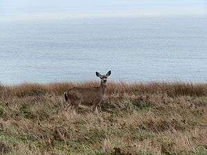
In 1978, ten tule elk (Cervus canadensis ssp. nannodes) were re-introduced to Point Reyes from the San Luis National Wildlife Refuge near Los Banos. By 2009, over 440 elk were counted at Tomales Point's 2,600 acres of coastal scrub and grasslands. In 1999, one hundred of the Tomales Point elk were moved to roam free in the Limantour wilderness area of the Seashore and above Drakes Beach.[16] The tule elk and the native black-tailed deer had been hunted, and the population of the black-tailed deer had also been suppressed by two introduced competitors, axis deer and fallow deer.[17]
Vegetation native to Point Reyes includes bishop pine, Douglas-fir, coyote brush, monkeyflower, poison oak, California blackberry, salal and coast redwood, among others.
Nearly 490 species of birds have been observed in the park and on adjacent waters.
Geology
The entire Point Reyes Peninsula is a piece of the Salinian Block transported northward by the San Andreas Fault. Its core is granite, unlike the terrain east of Tomales Bay. The granite rocks that form the peninsula were once continuous with the Tehachapi Mountains 350 miles south. In the 1906 earthquake, Point Reyes moved north 21 feet.[18]
Point Reyes is bounded to the east by the San Andreas Fault, which runs directly under Tomales Bay, and is structurally dominated by the Point Reyes Syncline. The Point Reyes Peninsula is on the Pacific Plate, while the rest of Marin County land is on the North American Plate.[19] The peninsula is a member of the Salinian Terrane, a segment of the southernmost Sierra Nevada range transported north from Southern California by movement along the San Andreas fault.[20] Simply speaking the peninsula consists of three major members: the Salinian Cretaceous crystalline basement, the overlying Pliocene sedimentary rocks, and the late Pleistocene marine terrace deposits of the southern peninsula.[21]
Climate
The U.S. Weather Bureau (now the National Weather Service) maintained a cooperative weather station in the Point Reyes lighthouse from 1914 to 1943. Based on those records, average January temperatures ranged from 45.1 °F (7.3 °C) to 54.1 °F (12.3 °C) and average September temperatures ranged from 51.7 °F (10.9 °C) to 61.0 °F (16.1 °C). The highest temperature recorded was 90 °F (32 °C) on October 3, 1917, and the lowest temperature recorded was 31 °F (-1 °C) on January 19, 1922. Annual precipitation averaged 17.05 inches (433 mm). The wettest year on record was 1941 with 31.37 inches (797 mm) and the driest year was 1923 was 7.32 inches (186 mm). The most precipitation in one month was 9.51 inches (242 mm) in December 1916. The maximum 24-hour precipitation was 2.65 inches (67 mm) on December 15, 1929.[22] Automated weather observations are now taken at the lighthouse. Weather observations are also taken in nearby Point Reyes Station and published in local newspapers, including the San Francisco Chronicle.
| Climate data for Point Reyes (1914 – 1943) | |||||||||||||
|---|---|---|---|---|---|---|---|---|---|---|---|---|---|
| Month | Jan | Feb | Mar | Apr | May | Jun | Jul | Aug | Sep | Oct | Nov | Dec | Year |
| Average high °F (°C) | 54.2 (12.3) |
54.1 (12.3) |
53.8 (12.1) |
54.5 (12.5) |
54.4 (12.4) |
56.7 (13.7) |
57.6 (14.2) |
57.9 (14.4) |
61.0 (16.1) |
61.0 (16.1) |
59.4 (15.2) |
55.4 (13) |
56.67 (13.69) |
| Average low °F (°C) | 45.1 (7.3) |
45.9 (7.7) |
45.4 (7.4) |
46.3 (7.9) |
46.7 (8.2) |
48.3 (9.1) |
49.4 (9.7) |
50.4 (10.2) |
51.2 (10.7) |
50.7 (10.4) |
49.9 (9.9) |
46.8 (8.2) |
48.01 (8.89) |
| Average precipitation inches (mm) | 3.41 (86.6) |
3.05 (77.5) |
1.94 (49.3) |
1.23 (31.2) |
0.66 (16.8) |
0.25 (6.4) |
0.04 (1) |
0.03 (0.8) |
0.36 (9.1) |
1.03 (26.2) |
1.73 (43.9) |
3.32 (84.3) |
17.05 (433.1) |
| Source: Western Regional Climate Center [23] | |||||||||||||

Fog
It can get very foggy and windy during certain parts of the year at the lighthouse, and to be effective, the lighthouse had to be situated below the characteristic high fog. When foggy, visibility is so slim that one cannot even view the lighthouse from the top of the approximately 300 steps necessary to walk down to reach it.[24]
The lighthouse serves a great purpose in such a foggy area, as there is no beach to wash up on; it is on a rocky cliff. Day or night, the light may be the only thing visible to ships. [24]
Recreation
The peninsula is a popular recreational destination for the nearby San Francisco Bay Area, especially for hiking on its many trails and sea kayaking the shores of Tomales Bay and the coast. Point Reyes National Seashore offers some of the finest birdwatching in the United States, It is also one of the best places to watch northern elephant seals in the winter months. More than 70,000 acres (300 km2) of habitat harbor an incredible variety of bird life. There are also popular oyster farms in and near the peninsula.
 Stairway to Point Reyes Lighthouse.
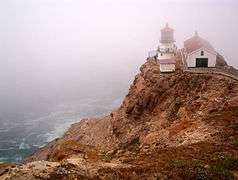 Point Reyes Lighthouse in fog.
 Tule elk grazing by the seaside.
 An elephant seal on the beach.
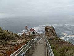 Point Reyes on a foggy day.
 Point Reyes sea shore.
See also
References
- ↑ Japan, Pitcairn, San Francisco Farallon Islands, above the Fog Bank, (c. 1891) Alan Bruce Harper and friend Mr. F.W. Wilsden (Liverpool apprentices) Logs "picking up a pilot"
- ↑ "Point Reyes, CA". Lighthouse Friends.
- ↑ "Coast Miwok at Point Reyes". National Park Service.
- ↑ "Kule Loklo Coast Miwok Cultural Exhibit". Point Reyes National Seashore Association.
- ↑ The Drake’s Cove site began its review by the National Park Service (NPS) in 1994 , thus starting an 18-year study of the suggested Drake sites. The first formal Nomination to mark the Nova Albion site at Drake’s Cove as a National Historic Landmark was provided to NPS on January 1, 1996. As part of its review, NPS obtained independent, confidential comments from professional historians. The NPS staff concluded that the Drake’s Cove site is the “most probable” and “most likely” Drake landing site. The National Park System Advisory Board Landmarks Committee sought public comments on the Port of Nova Albion Historic and Archaeological District Nomination and received more than two dozen letters of support and none in opposition. At the Committee’s meeting of November 9, 2011 in Washington, DC, representatives of the government of Spain, the National Oceanic and Atmospheric Administration and Congresswoman Lynn Wolsey all spoke in favor of the nomination: there was no opposition. Staff and the Drake Navigators Guild’s president, Edward Von der Porten, gave the presentation. The Nomination was strongly endorsed by Committee Member Dr. James M. Allan, Archeologist, and the Committee as a whole which approved the nomination unanimously. The National Park System Advisory Board sought further public comments on the Nomination : no additional comments were received. At the Board’s meeting on December 1, 2011 in Florida, the Nomination was further reviewed: the Board approved the nomination unanimously. On October 16, 2012 Secretary of the Interior Ken Salazar signed the nomination and on October 17, 2012,The Drakes Bay Historic and Archaeological District was formally announced as a new National Historic Landmark.
- 1 2 3 4 5 6 Baker, Gayle (2011). Point Reyes, A HarborTown History. HarborTown Histories.
- ↑ Bolton, Herbert E. (1927). Fray Juan Crespi: Missionary Explorer on the Pacific Coast, 1769-1774. HathiTrust Digital Library. pp. 226–227. Retrieved April 2014. Check date values in:
|access-date=(help) - ↑ Marin County rancho map
- ↑ Paul Liberatore (2010-07-15). "Far-out music at this year's Far West Fest". eToday. Retrieved 2012-04-13.
- ↑ Baker, Gayle, p. 97-102.
- ↑ Maritime Radio Historical Society of America
- 1 2 Campagna, C. (2008). "Mirounga angustirostris". IUCN Red List of Threatened Species. Version 2008. International Union for Conservation of Nature. Retrieved 2011-09-05.
- ↑ Charles Melville Scammon (2007). The marine mammals of the northwestern coast of North America: together with an account of the American whale-fishery. Heyday Books. p. 115. ISBN 978-1-59714-061-4. Retrieved 2011-09-05.
- ↑ Briton Cooper Busch (1987). The War Against the Seals: A History of the North American Seal Fishery. McGill-Queen's Press. p. 187. ISBN 978-0-7735-0610-7. Retrieved 2011-09-05.
- ↑ "Elephant Seals". National Park Service. Retrieved 2011-09-05.
- ↑ "Tule Elk". National Park Service. Retrieved 2011-09-05.
- ↑ "Non-Native Deer". Point Reyes National Seashore. National Park Service. Retrieved 23 December 2013.
- ↑ Alden, Peter; Heath, Fred (2008). National Audubon Society: Field Guide to California. New York: Alfred A. Knopf. p. 15. ISBN 978-0679446781.
- ↑ Galloway, A. J, 1977, Geology of the Point Reyes Peninsula, Marin County, California: California division of mines and geology bulletin, v. 202.
- ↑ Grove, Karen, 1993, Latest Cretaceous basin formation within the Salinian terrane of west-central California Geological Society of America Bulletin April, v. 105, p. 447-463.
- ↑ Woodley, S. R. and K. Grove, 2010, INTERPRETING PLEISTOCENE MARINE TERRACE DEPOSITS OVERLYING THE 82 Ka WAVE-CUT PLATFORM, POINT REYES PENINSULA, MARIN COUNTY, CALIFORNIA, San Francisco State Univ, Paper No. 18-26, Cordilleran Section - 106th Annual Meeting, and Pacific Section, American Association of Petroleum Geologists, 27–29 May 2010.
- ↑ Central California
- ↑ "WRCC". Retrieved June 19, 2015.
- 1 2 "Lighthouse History at Point Reyes". National Park Service. Retrieved 2012-04-13.
External links
| Wikimedia Commons has media related to Point Reyes National Seashore. |
Coordinates: 37°59′48″N 123°01′11″W / 37.99677°N 123.01984°W