Point Barrow
| Point Barrow Nuvuk | |
|---|---|
| Northernmost point of the United States | |
 Point Barrow Location within the state of Alaska | |
| Coordinates: 71°23′20″N 156°28′45″W / 71.38889°N 156.47917°W | |
| Country |
|
| State |
|
| Borough | North Slope |
| Time zone | Alaska (AKST) (UTC-9) |
| • Summer (DST) | AKDT (UTC-8) |
Point Barrow or Nuvuk is a headland on the Arctic coast in the U.S. state of Alaska, 9 miles (14 km) northeast of Utqiaġvik. It is the northernmost point of all the territory of the United States, at 71°23′20″N 156°28′45″W / 71.38889°N 156.47917°WCoordinates: 71°23′20″N 156°28′45″W / 71.38889°N 156.47917°W. The distance to the North Pole is 1,122 nautical miles (1,291 mi; 2,078 km). The northernmost point on the Canadian mainland, Murchison Promontory, is 40 miles (64 km) farther north.
Point Barrow is also an important geographical landmark, marking the limit between two marginal seas of the Arctic, the Chukchi Sea on its western side and the Beaufort Sea on the eastern, both delimited to the North by the edge of the map as seen here.
Archaeological evidence indicates that Point Barrow was occupied by the ancestors of the Iñupiat almost 1,000 years prior to the arrival of the first Europeans. The headland is an important archaeological site, yielding burials and artifacts associated with the Thule culture, including uluit and bola. The waters off Point Barrow are on the bowhead whale migration route and it is surmised that the site was chosen to make hunting easier.[1] There are also burial mounds in the area, at the nearby Birnirk Site, associated with the earlier Birnirk culture, identified in 1912 by Vilhjalmur Stefansson while excavating in the area.[2]
It was named by English explorer Frederick William Beechey in 1826 for Sir John Barrow, a statesman and geographer of the British Admiralty. The water around it is normally ice-free for two or three months a year, but this was not the experience of the early explorers. Beechey could not reach it by ship and had to send a ship's boat ahead. In 1826 John Franklin tried to reach it from the east and was blocked by ice. In 1837 Thomas Simpson walked 50 miles west to Point Barrow after his boats were stopped by ice. In 1849 William Pullen rounded it in two whale boats after sending two larger boats back west because of the ice.
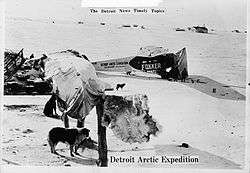
Point Barrow has been a jumping-off point for many Arctic expeditions, including the Wilkins-Detroit Arctic Expeditions and the April 15, 1928, Eielson-Wilkins flight across the Arctic Ocean to Spitsbergen.
It is 33 km (20.5 mi) northeast of the Rogers-Post Site, the scene of the airplane crash on August 15, 1935 that killed aviator Wiley Post and his passenger, the entertainer Will Rogers.
The "Shooting Station," is located a few miles southwest of Point Barrow. so named because between 1965 and 1972 it was a launch site for Nike-Cajun and Nike Apache sounding rockets. It is the site of a Global Atmosphere Watch atmospheric monitoring station and summer cabins constructed by locals and used for subsistence hunting and fishing.
The term Point Barrow whales refers to gray whales that were trapped in the ice at Point Barrow in 1988, which attracted attention from the public worldwide. The Iñupiat do not hunt gray whales and joined in rescue operations which also involved Soviet icebreakers.[3]
See also
| Wikimedia Commons has media related to Point Barrow. |
References
- ↑ Richard Black, "Bodies point to Alaska's past", BBC News, 31 December 2007.
- ↑ Archaeology of Prehistoric Native America By Guy E. Gibbon, Kenneth M. Ames
- ↑ Mauer, Richard (1988-10-18). "Unlikely Allies Rush to Free 3 Whales". New York Times. Retrieved 2008-06-12.