Point Arena, California
| City of Point Arena | |
|---|---|
| City | |
|
| |
 Location of Point Arena, California | |
 City of Point Arena Location in the United States | |
| Coordinates: 38°54′32″N 123°41′35″W / 38.90889°N 123.69306°WCoordinates: 38°54′32″N 123°41′35″W / 38.90889°N 123.69306°W | |
| Country |
|
| State |
|
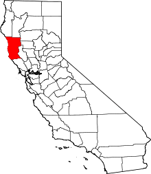
| County | Mendocino |
| Incorporated | July 11, 1908[1] |
| Area[2] | |
| • Total | 1.350 sq mi (3.496 km2) |
| • Land | 1.350 sq mi (3.496 km2) |
| • Water | 0 sq mi (0 km2) 0% |
| Elevation[3] | 118 ft (36 m) |
| Population (2010) | |
| • Total | 449 |
| • Density | 330/sq mi (130/km2) |
| Time zone | PST (UTC-8) |
| • Summer (DST) | PDT (UTC-7) |
| ZIP code | 95468 |
| Area code(s) | 707 |
| FIPS code | 06-57876 |
| GNIS feature ID | 1659411 |
| Website |
www |
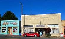
Point Arena (formerly, Punta Arenas and Puntas Arenas)[3] is a small coastal city in Mendocino County, California, United States. Point Arena is located 31 miles (50 km) west of Hopland,[4] at an elevation of 118 feet (36 m) .[3] The population was 449 at the 2010 census, down from 474 at the 2000 census, making it one of the smallest incorporated cities in the state. Its main street comprises part of State Route 1, California's coastal artery. Along with a number of other Mendocino County coastal communities, Point Arena is associated with the hippie and subsequent counterculture groups. Reportedly, the economy is largely geared toward servicing the summertime tourist industry. The City is near the headquarters of the tribal lands of Manchester Band of Pomo Indians of the Manchester-Point Arena Rancheria.
Geography and environment
The City of Point Arena is located at 38°54′32″N 123°41′35″W / 38.90889°N 123.69306°W.[3] It is in USPS ZIP code 95468.
According to the United States Census Bureau, the city has a total area of 1.4 square miles (3.6 km2), all of it land.
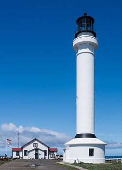
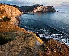
The city itself is built around a small natural cove, used as a harbor, and is located about a 1.5 miles (2.4 km) south of the actual Arena Point, a narrow peninsula jutting around 0.3 miles (0.48 km) into the Pacific Ocean. This is the location of the Point Arena Lighthouse, at 115 feet (35 m) the tallest lighthouse on the West coast of the United States. The lighthouse is also the closest location on the mainland (excluding Alaska) to Honolulu, Hawaii at a distance of 2,353 miles (3,787 km).
The city has three high schools: Point Arena High School, South Coast Continuation High School and the Pacific Community Charter High School. Students are allowed to cross-enroll and take courses at both the Point Arena High and Charter High schools, granting Point Arena students a broad curriculum from which to choose, although, due to limited teaching staff, many of the top students are left without options. The choice of the charter school has helped to keep in Point Arena many students who formerly commuted to Mendocino to attend its high school. Several feeder schools bring students through grammar school before sending them to Point Arena High School or the Charter School, meaning that the schools draw from a large pool of students in southern Mendocino and northern Sonoma counties.
A variety of fauna and flora occur in the Point Arena area. The location is also sometimes a range demarcation for occurrence of some species. For example, the Pacific Giant Salamander occurs at Point Arena and at points south, but not at all to the north.[5]
The Point Arena State Marine Reserve & Point Arena State Marine Conservation Area are two marine protected areas that extend offshore from Point Arena. Sea Lion Cove State Marine Conservation Area and Saunders Reef State Marine Conservation Area lie south of Point Arena. Like underwater parks, these marine protected areas help conserve ocean wildlife and marine ecosystems.
Sound levels in Point Arena are relatively quiet, with many locations at night-time dominated by natural sounds such as those of the surf. The firm of Earth Metrics Inc., who prepared the Noise Element of the Point Arena General Plan, found that, even considering the presence of logging trucks on main city streets, composite sound levels rarely exceed 55 Leq.[6] The maximum acceptable sound level specified in that General Plan Element is 60 Leq for residential areas.
Climate
Point Arena has cool, wet winters and mild, relatively dry summers. According to the Köppen climate classification system, it has warm-summer Mediterranean climate (Csb). The average January temperatures are a maximum of 56.4 °F (13.6 °C) and a minimum of 40.2 °F (4.6 °C). The average July temperatures are a maximum of 65.2 °F (18.4 °C) and a minimum of 49.9 °F (9.9 °C). There are an average of only 0.3 days with highs of 90 °F (32 °C) or higher and an average of 14.1 days with lows of 32 °F (0 °C) or lower. The record high temperature was 95 °F (35 °C) on August 12, 1947, and September 28, 1966. The record low temperature was 22 °F (−6 °C) on January 21, 1962.
Average annual precipitation is 41.28 inches (1,049 mm). There are an average of 83 days with measurable precipitation. The wettest year was 1983 with 83.34 inches (2,117 mm) and the driest year was 1976 with 21.23 inches (539 mm). The most precipitation in one month was 21.99 inches (559 mm). The most precipitation in 24 hours was 5.09 inches (129 mm) on January 24, 1944.[7]
| Climate data for Point Arena | |||||||||||||
|---|---|---|---|---|---|---|---|---|---|---|---|---|---|
| Month | Jan | Feb | Mar | Apr | May | Jun | Jul | Aug | Sep | Oct | Nov | Dec | Year |
| Record high °F (°C) | 76 (24) |
81 (27) |
86 (30) |
83 (28) |
89 (32) |
86 (30) |
89 (32) |
95 (35) |
95 (35) |
92 (33) |
79 (26) |
74 (23) |
95 (35) |
| Average high °F (°C) | 56.4 (13.6) |
57.2 (14) |
57.8 (14.3) |
59.1 (15.1) |
61.1 (16.2) |
63 (17) |
65.2 (18.4) |
65.7 (18.7) |
66.7 (19.3) |
64.9 (18.3) |
60.7 (15.9) |
57.2 (14) |
61.3 (16.3) |
| Average low °F (°C) | 40.2 (4.6) |
42 (6) |
42.4 (5.8) |
43.1 (6.2) |
46 (8) |
48.6 (9.2) |
49.9 (9.9) |
50.5 (10.3) |
49.8 (9.9) |
47.2 (8.4) |
43.3 (6.3) |
41.4 (5.2) |
45.4 (7.4) |
| Record low °F (°C) | 22 (−6) |
25 (−4) |
26 (−3) |
28 (−2) |
30 (−1) |
8 (−13) |
38 (3) |
38 (3) |
33 (1) |
4 (−16) |
25 (−4) |
24 (−4) |
4 (−16) |
| Average precipitation inches (mm) | 7.73 (196.3) |
6.89 (175) |
5.55 (141) |
2.94 (74.7) |
0.93 (23.6) |
0.29 (7.4) |
0.12 (3) |
0.3 (8) |
0.72 (18.3) |
2.91 (73.9) |
5.65 (143.5) |
7.26 (184.4) |
41.28 (1,048.5) |
| Average precipitation days | 12 | 12 | 12 | 7 | 5 | 2 | 1 | 1 | 3 | 6 | 10 | 12 | 83 |
| Source: [8] | |||||||||||||
Geology
The San Andreas Fault runs out to sea at Point Arena. The 1906 earthquake was strongly felt at Point Arena and caused moderate damage.
The Point Arena Mountain Beaver
The Point Arena area is home to an endangered species of rodent known as the Point Arena Mountain Beaver (Aplodontia rufa nigra). According to the U.S. Fish and Wildlife Service, the habitat for this sub-species of Mountain Beaver lies only within a 24 sq mi (62 km2) area around Point Arena. The biggest threat to the PAMB is loss of habitat, and it was officially listed as an endangered species on December 12, 1991. Much local folklore revolves around this mysterious creature.[9]
History
The first European to record Point Arena was Spaniard Bartolomé Ferrer in 1543, who named it Cabo de Fortunas (Spanish for "cape of fortunes"). The cape was renamed to Punta Delgado (narrow point) in 1775 by lieutenant Juan Francisco de la Bodega y Quadra (commander of the schooner Sonora), part of a royal expedition chartered by the government of Mexico to map the north coast of Alta California. Later the point, and the small harbor town south of it, were called Barra de Arena (i.e. sandbar) and finally Point Arena (literally "sand point").
The Punta Arenas post office opened in 1858, and was renamed Point Arena in 1889.[4] The first store at Point Arena opened in 1859.[4] Point Arena incorporated in 1908.[4]
The Point Arena area is also home to the Point Arena Cable Station, although the station is technically located in nearby Manchester. Built in 1956 by AT&T Corporation, the cable station serves as the eastern terminus of several undersea cables, including the JUSCN and connections to Hawaii and Canada.[10][11][12] In 2002, AT&T applied for a permit from the EPA to connect an existing fiber optic conduit to the cable station, since further construction would cause incidental damage to the habitat of the endangered Point Arena Mountain Beaver.[13]
Demographics
| Historical population | |||
|---|---|---|---|
| Census | Pop. | %± | |
| 1880 | 198 | — | |
| 1890 | 709 | 258.1% | |
| 1910 | 497 | — | |
| 1920 | 394 | −20.7% | |
| 1930 | 385 | −2.3% | |
| 1940 | 374 | −2.9% | |
| 1950 | 372 | −0.5% | |
| 1960 | 596 | 60.2% | |
| 1970 | 424 | −28.9% | |
| 1980 | 425 | 0.2% | |
| 1990 | 407 | −4.2% | |
| 2000 | 474 | 16.5% | |
| 2010 | 449 | −5.3% | |
| Est. 2015 | 453 | [14] | 0.9% |
2010
The 2010 United States Census[16] reported that Point Arena had a population of 449. The population density was 332.6 people per square mile (128.4/km²). The racial makeup of Point Arena was 305 (67.9%) White, 2 (0.4%) African American, 1 (0.2%) Native American, 0 (0.0%) Asian, 0 (0.0%) Pacific Islander, 118 (26.3%) from other races, and 23 (5.1%) from two or more races. Hispanic or Latino of any race were 150 persons (33.4%).
The Census reported that 449 people (100% of the population) lived in households, 0 (0%) lived in non-institutionalized group quarters, and 0 (0%) were institutionalized.
There were 192 households, out of which 57 (29.7%) had children under the age of 18 living in them, 62 (32.3%) were opposite-sex married couples living together, 25 (13.0%) had a female householder with no husband present, 13 (6.8%) had a male householder with no wife present. There were 20 (10.4%) unmarried opposite-sex partnerships, and 3 (1.6%) same-sex married couples or partnerships. 71 households (37.0%) were made up of individuals and 28 (14.6%) had someone living alone who was 65 years of age or older. The average household size was 2.34. There were 100 families (52.1% of all households); the average family size was 3.08.
The population was spread out with 112 people (24.9%) under the age of 18, 31 people (6.9%) aged 18 to 24, 116 people (25.8%) aged 25 to 44, 132 people (29.4%) aged 45 to 64, and 58 people (12.9%) who were 65 years of age or older. The median age was 40.0 years. For every 100 females there were 109.8 males. For every 100 females age 18 and over, there were 103.0 males.
There were 225 housing units at an average density of 166.7 per square mile (64.4/km²), of which 87 (45.3%) were owner-occupied, and 105 (54.7%) were occupied by renters. The homeowner vacancy rate was 4.4%; the rental vacancy rate was 8.7%. 189 people (42.1% of the population) lived in owner-occupied housing units and 260 people (57.9%) lived in rental housing units.
2000
As of the census[17] of 2000, there were 474 people, 191 households, and 109 families residing in the city. The population density was 348.5 people per square mile (134.6/km²). There were 218 housing units at an average density of 160.3 per square mile (61.9/km²). The racial makeup of the city was 73.63% White, 1.05% African American, 3.80% Native American, 0.21% Asian, 18.78% from other races, and 2.53% from two or more races. Hispanic or Latino of any race were 28.48% of the population.
There were 191 households out of which 33.0% had children under the age of 18 living with them, 39.3% were married couples living together, 13.6% had a female householder with no husband present, and 42.9% were non-families. 32.5% of all households were made up of individuals and 8.4% had someone living alone who was 65 years of age or older. The average household size was 2.48 and the average family size was 3.30.
In the city the population was spread out with 32.9% under the age of 18, 7.2% from 18 to 24, 27.8% from 25 to 44, 23.0% from 45 to 64, and 9.1% who were 65 years of age or older. The median age was 33 years. For every 100 females there were 110.7 males. For every 100 females age 18 and over, there were 106.5 males.
The median income for a household in the city was $27,083, and the median income for a family was $32,885. Males had a median income of $21,042 versus $15,000 for females. The per capita income for the city was $12,591. About 24.1% of families and 26.0% of the population were below the poverty line, including 36.0% of those under age 18 and 4.5% of those age 65 or over.
Government
Point Arena is governed by an elected, five-member city council which includes the mayor.[18]
In the state legislature, Point Arena is in the 2nd Senate District, represented by Democrat Mike McGuire,[19] and the 2nd Assembly District, represented by Democrat Jim Wood.[20]
Federally, Point Arena is in California's 2nd congressional district, represented by Democrat Jared Huffman.[21]
References
- ↑ "California Cities by Incorporation Date" (Word). California Association of Local Agency Formation Commissions. Retrieved August 25, 2014.
- ↑ "2010 Census U.S. Gazetteer Files – Places – California". United States Census Bureau.
- 1 2 3 4 U.S. Geological Survey Geographic Names Information System: Point Arena, California
- 1 2 3 4 Durham, David L. (1998). California's Geographic Names: A Gazetteer of Historic and Modern Names of the State. Clovis, Calif.: Word Dancer Press. p. 124. ISBN 1-884995-14-4.
- ↑ C. Michael Hogan (2008) California Giant Salamander: Dicamptodon ensatus, GlobalTwitcher.com, ed. Nicklas Stromberg
- ↑ Noise Element of the Point Arena General Plan , Earth Metrics Inc Archived October 5, 2011, at the Wayback Machine.
- ↑ "POINT ARENA, CALIFORNIA - Climate Summary". Wrcc.dri.edu. Retrieved 2013-07-16.
- ↑ "POINT ARENA, CALIFORNIA (047009)". Western Regional Climate Center. Retrieved November 18, 2015.
- ↑ "Point Arena Mountain Beaver Species Profile". Fws.gov. Retrieved 2013-07-16.
- ↑ "Cable Station Life". Privateline.com. Retrieved 2013-07-16.
- ↑ "Journal Article". SpringerLink. 1992-04-25. Retrieved 2013-07-16.
- ↑ "Point Arena Cable Station". Thecentraloffice.com. Retrieved 2013-07-16.
- ↑ "Incidental Take Permit and Habitat Conservation Plan for AT&T Corporation| Federal Register Environmental Documents | USEPA". Epa.gov. Retrieved 2013-07-16.
- ↑ "Annual Estimates of the Resident Population for Incorporated Places: April 1, 2010 to July 1, 2015". Retrieved July 2, 2016.
- ↑ "Census of Population and Housing". Census.gov. Retrieved June 4, 2015.
- ↑ "2010 Census Interactive Population Search: CA - Point Arena city". U.S. Census Bureau. Retrieved July 12, 2014.
- ↑ "American FactFinder". United States Census Bureau. Retrieved 2008-01-31.
- ↑ "City Council". City of Point Arena. Retrieved March 27, 2015.
- ↑ "Senators". State of California. Retrieved March 10, 2013.
- ↑ "Members Assembly". State of California. Retrieved March 2, 2013.
- ↑ "California's 2nd Congressional District - Representatives & District Map". Civic Impulse, LLC. Retrieved March 1, 2013.
External links
| Wikivoyage has a travel guide for Point Arena. |
| Wikimedia Commons has media related to Point Arena, California. |
- Official website
- B. Bryan Preserve
- Point Arena lighthouse
- Manchester State Beach
- Schooner Gulch State Beach
- Article about pier fishing at the Point Arena Pier