Plymouth Breakwater
Coordinates: 50°20′2.98″N 4°8′55.18″W / 50.3341611°N 4.1486611°W
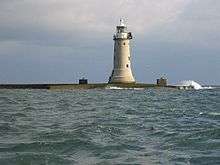 Plymouth Breakwater Lighthouse | |
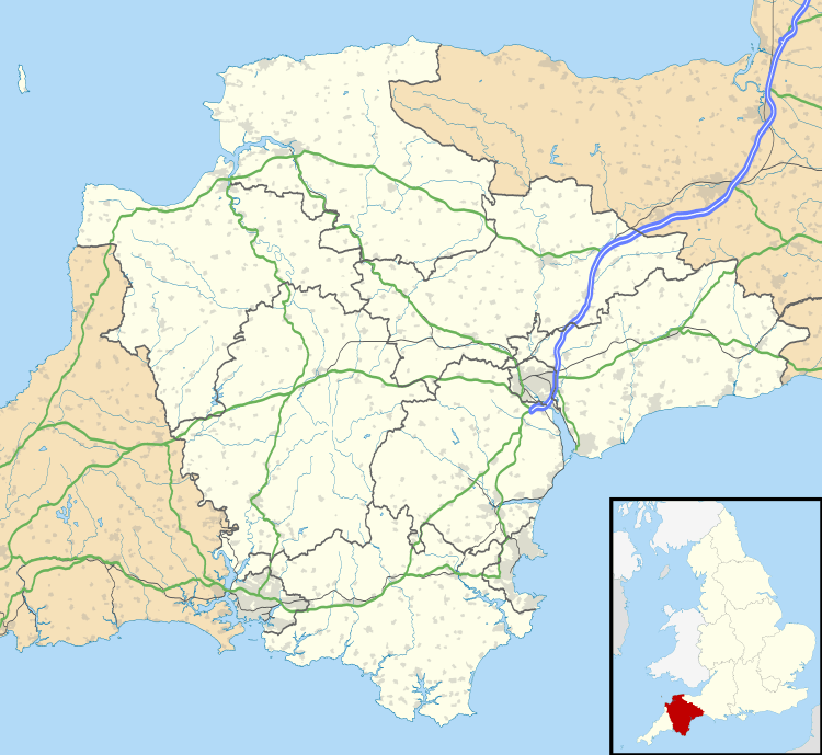 Devon | |
| Location |
Plymouth Sound Devon England |
|---|---|
| Coordinates | 50°20′04″N 4°09′32″W / 50.334553°N 4.158773°W |
| Year first constructed | 1844 |
| Construction | stone tower |
| Tower shape | cylindrical tower with balcony and lantern |
| Markings / pattern | white tower and lantern |
| Height | 23.5 metres (77 ft) |
| Focal height | 19 metres (62 ft) |
| Characteristic |
Fl WR 10s. Iso W 4s. at 12 metres (39 ft) |
| Fog signal | blast every 15s. |
| Admiralty number | A0114 |
| NGA number | 0148 |
| ARLHS number | ENG-104 |
| Managing agent | Ministry of Defence[1] |
Plymouth Breakwater is a 1,560-metre (1,710 yd) stone breakwater protecting Plymouth Sound and the anchorages near Plymouth, Devon, England. It is 13 metres (43 ft) wide at the top and the base is 65 metres (213 ft). It lies in about 10 metres (33 ft) of water. Around 4 million tons of rock were used in its construction in 1812 at the then-colossal cost of £1.5 million (equivalent to £90.1 million today).
History
In 1806, as the Napoleonic Wars impended, Lord St. Vincent commissioned John Rennie and Joseph Whidbey to plan a means of making Plymouth Bay a safe anchorage for the Channel Fleet. In 1811 came the order to begin construction; Whidbey was appointed Acting Superintending Engineer. This task required great engineering, organizational and political skills, as the many strictly technical challenges were complicated by the significant resources devoted to the project, from which various parties evidenced a desire for advantage. Nearly 4,000,000 (four million) tons of stone were quarried and transported, using about a dozen ships innovatively designed by the two engineers. A paper to the Royal Society suggests that Whidbey found many fossils as a result of the quarrying necessary to the breakwater.[2]
The foundation stone was laid on Shovel Rock on August 8, 1812. It followed a line over Panther Rock, Shovel and St. Carlos Rocks, and was sufficiently completed by 1814 to shelter ships of the line. Napoleon was reported as commenting that the breakwater was a grand thing, as he passed by it on the way to exile on St. Helena in 1815.
Severe storm damage in 1817 and 1824 prompted a change in the profile and height. Whidbey continued to work on the breakwater and other engineering projects, including the breakwater's lighthouse (designed by Walker & Burgess for Trinity House), until retirement around 1830. It was finished by 1841, the final work being finished by Rennie's son, Sir John Rennie. The lighthouse became operational in 1844, and soon afterwards a horse-drawn omnibus was driven from end to end, with a full complement of passengers and accompanied by a military band.[3] A beacon was placed at the eastern end, consisting of a 6-foot (1.8 m) spherical cage on a 17-foot (5.2 m) pole; the cage was designed as a refuge for six shipwrecked sailors.[4]
Plymouth Breakwater Fort
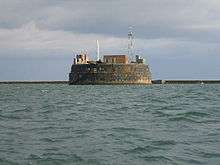
In 1860, a Royal Commission, established by Lord Palmerston, produced a plan for the defence of Plymouth and other Royal Dockyards.[5] The Breakwater Fort was designed to defend the entrances to Plymouth Sound in conjunction with forts and batteries on either shore. Designed by Captain Siborne, work on the oval masonry sea fort started in 1861 and the main structure was completed in 1865. It has its foundations on Shovel Rock and is 35 yards inside the Breakwater. After several changes in plan, the fort was finally armed in 1879 with fourteen 12.5-inch and four 10-inch rifled muzzle-loading guns in armoured casemates. Although the fort had been disarmed before World War I, it served as a signal station, and from 1937, an anti-aircraft training school. It was finally released by the military in 1976.
Gallery
 Plymouth breakwater from Wembury
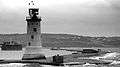 Plymouth breakwater from Kingsand showing the 1844 lighthouse and the Breakwater Fort beyond
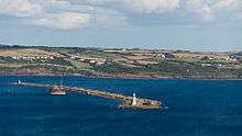 Plymouth breakwater, viewed from above Kingsand
See also
- National Harbor of Refuge, a comparable structure at the mouth of Delaware Bay in the United States, intended principally for civilian use.
- List of lighthouses in England
References
- ↑ Plymouth Breakwater The Lighthouse Directory. University of North Carolina at Chapel Hill. Retrieved May 4, 2016
- ↑ Whidbey, Joseph (1817). "A Farther Account of Fossil Bones Discovered in Caverns Inclosed in the Lime Stone Rocks at Plymouth". Philosophical Transactions of the Royal Society of London, Vol. 111. pp. 133–135. Retrieved 2007-02-01.
- ↑ Plymouth Times, 27 July 1844
- ↑ Moseley, Brian (26 February 2013). "[Plymouth] Breakwater". The Encyclopaedia of Plymouth History. Archived from the original on 17 May 2013. Retrieved 12 February 2015.
- ↑ "The Breakwater Fort, Plymouth - the Palmerston battery at the mouth of the Sound". BBC. Retrieved 2011-10-22.
External links
| Wikimedia Commons has media related to Plymouth Breakwater. |