Pleasantville, St. John's
| Pleasentville | |
|---|---|
| Neighbourhood | |
|
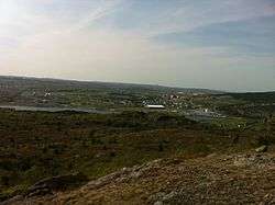
Pleasantville from Signal Hill | |
| Country |
|
| Province |
|
| City | St. John's |
| Ward | 1 |
| Government | |
| • Administrative body | St. John's City Council |
| • Councilor | Danny Breen |
The neighbourhood of Pleasantville in St. John's, Newfoundland and Labrador is located in the east end of the city, directly north of the downtown. The neighbourhood extends from the north side of Quidi Vidi Lake northward to Newfoundland Drive.
Most of the area was developed by the United States Military in 1941 and is the former site of Fort Pepperrell, later Pepperrell Air Force Base. The base closed in 1960, and in 1961 the land was transferred to the Canadian Government for use by the Department of National Defence.[1] Many of the buildings the US Military constructed in the area have since been either demolished or turned into government offices or residential units. Pleasantville is now being redeveloped by Canada Lands Company (CLC) into a residential neighbourhood.[2][3]
Redevelopment
In 2006, Canada Lands Company, a federal Crown corporation, acquired the federal government's portion of the land with the plan to redevelop the area into a residential neighbourhood.[1] After public consultations CLC applied to the city to construct 958 residential units and 5800 sq. m of commercial space.[4] The residential units will include single family homes, townhouses, duplexes, multi-story units and an assisted living complex. The development also included a $101 million upgrade to the Canadian Forces Station which is located onside of the residential development. The city council approved the proposal in 2009, and progress began in 2010 on the redevelopment.[1][2][3]
See also
References
- 1 2 3 "Pleasantville Backgrounder" (PDF). Canada Lands Company. Retrieved 23 May 2012.
- 1 2 "Community within a community: Housing plan pitched for Pleasantville". Canadian Broadcasting Corporation. 19 November 2008. Retrieved 23 May 2012.
- 1 2 "Pleasantvill Groundbreaking Marks New Step Forward For Major Real Estate Project In St. John's". Canada Lands Comnpany. Retrieved 23 May 2012.
- ↑ "Pleasantville Site Plan" (PDF). Canada Lands Company. Retrieved 23 May 2012.
| Government | |
|---|---|
| Geography | |
| Sports | |
| Culture | |
| Transportation | |
| |
Coordinates: 47°35′16″N 52°40′50″W / 47.58778°N 52.68056°W