Pleasant Ridge, Michigan
| Pleasant Ridge | |
|---|---|
| City | |
| City of Pleasant Ridge | |
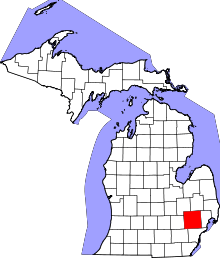
 Location in the state of Michigan | |
| Coordinates: 42°28′16″N 83°8′32″W / 42.47111°N 83.14222°W | |
| Country | United States |
| State | Michigan |
| County | Oakland |
| Government | |
| • Mayor | Kurt Metzger |
| Area[1] | |
| • City | 0.57 sq mi (1.48 km2) |
| • Land | 0.57 sq mi (1.48 km2) |
| • Water | 0 sq mi (0 km2) |
| Elevation | 650 ft (195 m) |
| Population (2010)[2] | |
| • City | 2,526 |
| • Estimate (2012[3]) | 2,544 |
| • Density | 4,431.6/sq mi (1,711.1/km2) |
| • Metro | 4,296,250 |
| Time zone | EST (UTC-5) |
| • Summer (DST) | EDT (UTC-4) |
| ZIP code | 48069 |
| Area code(s) | 248 |
| FIPS code | 26-64900[4] |
| GNIS feature ID | 0635117[5] |
Pleasant Ridge is a city in Oakland County in the U.S. state of Michigan. The population was 2,526 at the 2010 census.[6]
Geography
According to the United States Census Bureau, the city has a total area of 0.57 square miles (1.48 km2), all land.[1]
History
Pleasant Ridge began with the subdivision of the Mayday farm by Burt Taylor in 1913. It incorporated as a village in 1921 and as a city in 1927.[7] On December 1, 2009, the Pleasant Ridge City Council approved plans for the city's first bar. Pleasant Ridge had previously been a dry community.[8]
The city is named after the slight ridge that ran through the city.
One of Pleasant Ridge's most popular landmarks was Hedge's Wigwam, a Native American-themed cafeteria-style restaurant which was located at 10 Mile and Woodward from 1927 until 1967.
Pleasant Ridge was actively involved in disputing the construction of Interstate 696.
Demographics
| Historical population | |||
|---|---|---|---|
| Census | Pop. | %± | |
| 1920 | 472 | — | |
| 1930 | 2,885 | 511.2% | |
| 1940 | 3,391 | 17.5% | |
| 1950 | 3,594 | 6.0% | |
| 1960 | 3,807 | 5.9% | |
| 1970 | 3,989 | 4.8% | |
| 1980 | 3,217 | −19.4% | |
| 1990 | 2,775 | −13.7% | |
| 2000 | 2,594 | −6.5% | |
| 2010 | 2,526 | −2.6% | |
| Est. 2015 | 2,556 | [9] | 1.2% |
2010 census
As of the census[2] of 2010, there were 2,526 people, 1,115 households, and 674 families residing in the city. The population density was 4,431.6 inhabitants per square mile (1,711.1/km2). There were 1,153 housing units at an average density of 2,022.8 per square mile (781.0/km2). The racial makeup of the city was 94.7% White, 1.9% African American, 0.1% Native American, 1.1% Asian, 0.3% from other races, and 1.9% from two or more races. Hispanic or Latino of any race were 1.7% of the population.
There were 1,115 households of which 26.6% had children under the age of 18 living with them, 52.7% were married couples living together, 5.7% had a female householder with no husband present, 2.0% had a male householder with no wife present, and 39.6% were non-families. 28.4% of all households were made up of individuals and 9.5% had someone living alone who was 65 years of age or older. The average household size was 2.27 and the average family size was 2.87.
The median age in the city was 43.4 years. 20.3% of residents were under the age of 18; 3.5% were between the ages of 18 and 24; 29.4% were from 25 to 44; 32.6% were from 45 to 64; and 14.4% were 65 years of age or older. The gender makeup of the city was 50.8% male and 49.2% female.
Pleasant Ridge has a high percentage of same-sex couples. According to the 2010 Census, it has the seventh-highest rate of same-sex couples in the nation with 59.6 per 1,000.[11] It is adjacent to Ferndale, a suburb considered the heart of the LGBT community in the area.[12]
2000 census
As of the census[4] of 2000, there were 2,594 people, 1,110 households, and 712 families residing in the city. The population density was 4,563.7 per square mile (1,757.1/km²). There were 1,129 housing units at an average density of 1,986.3 per square mile (764.8/km²). The racial makeup of the city was 96.57% White, 0.85% African American, 0.42% Native American, 0.89% Asian, 0.04% Pacific Islander, 0.39% from other races, and 0.85% from two or more races. Hispanic or Latino of any race were 1.77% of the population.
There were 1,110 households out of which 29.1% had children under the age of 18 living with them, 55.5% were married couples living together, 7.0% had a female householder with no husband present, and 35.8% were non-families. 26.1% of all households were made up of individuals and 8.4% had someone living alone who was 65 years of age or older. The average household size was 2.33 and the average family size was 2.87.
In the city the population was spread out with 22.0% under the age of 18, 3.9% from 18 to 24, 33.4% from 25 to 44, 29.3% from 45 to 64, and 11.4% who were 65 years of age or older. The median age was 40 years. For every 100 females there were 99.8 males. For every 100 females age 18 and over, there were 97.1 males.
The median income for a household in the city was $80,682, and the median income for a family was $92,134. Males had a median income of $66,071 versus $44,231 for females. The per capita income for the city was $40,846. About 1.2% of families and 2.0% of the population were below the poverty line, including 2.3% of those under age 18 and 2.0% of those age 65 or over.
See also
References
- 1 2 "US Gazetteer files 2010". United States Census Bureau. Retrieved November 25, 2012.
- 1 2 "American FactFinder". United States Census Bureau. Retrieved November 25, 2012.
- ↑ "Population Estimates". United States Census Bureau. Retrieved June 3, 2013.
- 1 2 "American FactFinder". United States Census Bureau. Retrieved January 31, 2008.
- ↑ "Pleasant Ridge, Michigan". Geographic Names Information System. United States Geological Survey.
- ↑ "Race, Hispanic or Latino, Age, and Housing Occupancy: 2010 Census Redistricting Data (Public Law 94-171) Summary File (QT-PL), Pleasant Ridge city, Michigan". American FactFinder 2. United States Census Bureau. Retrieved August 19, 2011.
- ↑ Romig, Walter (1986). Michigan Place Names. Detroit: Wayne State University Press. p. 448. ISBN 0-8143-1838-X.
- ↑ "Cork Opens Doors in Pleasant Ridge". Woodward Talk. November 24, 2010. Retrieved August 25, 2011.
- ↑ "Annual Estimates of the Resident Population for Incorporated Places: April 1, 2010 to July 1, 2015". Retrieved July 2, 2016.
- ↑ "Census of Population and Housing". Census.gov. Retrieved June 4, 2015.
- ↑ Tavernise, Sabrina (August 25, 2011). "New Numbers, and Geography, for Gay Couples". The New York Times. Retrieved August 25, 2011.
- ↑ Case, Wendy. "Affirming Ferndale". Metro Times. Retrieved August 25, 2011.
External links
Coordinates: 42°28′16″N 83°8′32″W / 42.47111°N 83.14222°W
| Topics |  | |
|---|---|---|
| Detroit | ||
| Municipalities over 80,000 | ||
| Municipalities 40,000 to 80,000 | ||
| Cultural enclaves | ||
| Satellite cities | ||
| Counties in MSA | ||
| Counties in CSA | ||