Plashes Wood
| Site of Special Scientific Interest | |
 | |
| Area of Search | Hertfordshire |
|---|---|
| Grid reference | TL349165 |
| Interest | Biological |
| Area | 19.7 hectares |
| Notification | 1984 |
| Location map | Magic Map |
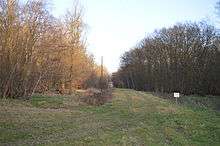
Plashes Wood is a 71.9 hectare biological Site of Special Scientific Interest south of Standon in Hertfordshire. The local planning authority is East Hertfordshire District Council.[1][2] The wood is private property.[3]
The site is mainly oak and hornbeam woodland near the northern limit of its natural distribution. It has varied ground flora on soils from damp heavy clay to light gravels. Common plants include bramble, bluebells and dog' mercury. There are also ponds and extensive clearings dominated by bracken, and other flora including hoary cinquefoil.[1]
There is access from a footpath next to Colliers End church in Ermine Street.
| Wikimedia Commons has media related to Plashes Wood. |
References
- 1 2 "Plashes Wood citation" (PDF). Sites of Special Scientific Interest. Natural England. Retrieved 11 March 2015.
- ↑ "Map of Plashes Wood". Sites of Special Scientific Interest. Natural England. Retrieved 11 March 2015.
- ↑ Notices on the site
Coordinates: 51°52′01″N 0°00′21″E / 51.8669°N 0.0058°E
This article is issued from Wikipedia - version of the 3/18/2016. The text is available under the Creative Commons Attribution/Share Alike but additional terms may apply for the media files.