Planken
| Planken | |||
|---|---|---|---|
| Municipality | |||
|
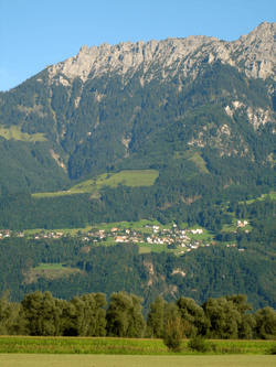
Overlooking Planken | |||
| |||
 Planken and its exclaves in Liechtenstein | |||
| Coordinates: 47°11′N 9°32′E / 47.183°N 9.533°ECoordinates: 47°11′N 9°32′E / 47.183°N 9.533°E | |||
| Country |
| ||
| Electoral district | Oberland | ||
| Villages | Hinterschellenberg | ||
| Area | |||
| • Total | 5.3 km2 (2.0 sq mi) | ||
| Elevation | 786 m (2,579 ft) | ||
| Population (30-6-2015)[1] | |||
| • Total | 432 | ||
| Time zone | CET (UTC+1) | ||
| • Summer (DST) | CEST (UTC) | ||
| Postal code | 9498 | ||
| Area code(s) | 7006 | ||
| ISO 3166 code | LI-05 | ||
| Website | www.planken.li | ||

Planken is the least populated of Liechtenstein's municipalities. The entire community of Planken is estimated to have 366 people.
History
Its name is said to derive from a Latin word for rising meadows. Its most notable structure is an eighteenth-century chapel that was redesigned in 1955 under the supervision of architect Felix Schmid of Rapperswil.
Notable people
- Hanni Wenzel, alpine skier
- Andreas Wenzel, alpine skier
- Tina Weirather, alpine skier
Gallery
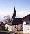 Village church
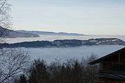 View vith fog
References
- ↑ (German) 2015 statistics for Liechtenstein
External links
![]() Media related to Planken at Wikimedia Commons
Media related to Planken at Wikimedia Commons
This article is issued from Wikipedia - version of the 10/9/2016. The text is available under the Creative Commons Attribution/Share Alike but additional terms may apply for the media files.