Plains of San Agustin
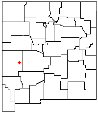
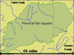
The Plains of San Agustin (sometimes listed as the Plains of San Augustin) is a region in the southwestern U.S. state of New Mexico in the San Agustin Basin, south of U.S. Highway 60. The area spans Catron and Socorro Counties, about 50 miles (80 km) west of the town of Socorro and about 25 miles north of Reserve. The plains extend roughly northeast-southwest, with a length of about 55 miles (88 km) and a width varying between 5–15 miles (8–24 km). The basin is bounded on the south by the Luera Mountains and Pelona Mountain (outliers of the Black Range); on the west by the Tularosa Mountains; on the north by the Mangas, Crosby, Datil, and Gallinas Mountains; and on the east by the San Mateo Mountains. The Continental Divide lies close to much of the southern and western boundaries of the plains.[1]
The Plains of San Agustin were purportedly the site of a UFO crash landing in 1947, an event thought to be connected to the Roswell UFO incident.[2]
Geology
Geologically, the Plains of San Agustin lie within the Mogollon-Datil volcanic field, just south of the southeast edge of the Colorado Plateau, and west of the Rio Grande Rift Valley. The basin is a graben (a downdropped block which subsided between parallel faults). The graben is younger than the Datil-Mogollon volcanic eruptions.[3] The flat floor of the plains was created by a Pleistocene lake (Lake San Agustin).[4] Although the graben has dropped an estimated 4,000 ft., the surface relief has been reduced to about 2,000 ft. by sedimentation. A great deal of the sediments entered the San Agustin basin prior to the formation of Lake San Agustin in the last glacial period. There is no evidence of tectonic activity in the area after Lake San Agustin became extinct.[3]
Ecologically, the plains lie near the northern end of the Chihuahuan Desert (though the ranges surrounding the Gila River headwaters intervene), which is dominated by shrublands.
Landmarks
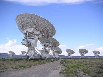

The plains are probably best known as the site of the Very Large Array, a radio astronomy observatory. The plains were chosen for the observatory because of their isolated location away from large population centers, and the partial shielding effect of the surrounding mountain ranges. The edges of the plains have sites of archaeological interest such as a prehistoric rockshelter known as Bat Cave.
Other sites in the area include a ghost town called Old Horse Springs and the Ake Site, a prehistoric occupation site.
Notes
- ↑ New Mexico Atlas and Gazetteer, Second Edition, DeLorme Mapping, 2000.
- ↑ Friedman, Stanton T. & Berliner, Don (1992). Crash at Corona: The U.S. Military Retrieval and Cover-up of a UFO. New York: Paragon House. p. 134. ISBN 978-1-55778-449-0.
- 1 2 Stearns, Charles E. (1962) Geology of the north half of the Pelona Quadrangle, Catron County, New Mexico Bulletin 78, New Mexico Bureau of Mines and Mineral Resources, Socorro, NM, OCLC 3926534
- ↑ Halka Chronic, Roadside Geology of New Mexico, Mountain Press Publishing, Missoula, 1987, ISBN 0-87842-209-9.
Sources
- Powers, William E. (1939) "Basin and Shore Features of the Extinct Lake, San Augustin, New Mexico" Journal of Geomorphology 2: pp. 345–356
- Weber, Robert H. (1994) "Pluvial Lakes of the Plains of San Augustin" In Chamberlin, R.M. et al. (1994) Mogollon Slope, West-Central New Mexico and East-Central Arizona pp. 9–11, New Mexico Geological Society, Forty-Fifth Annual Field Conference, Socorro, New Mexico.
- Holliday, Vance T. 'et al. (2007) "Paleoindian Geoarchaeology and the Archaeological Potential on the Plains of San Augustin, New Mexico" Argonaut Archaeological Research Fund, Department of Anthropology and Department of Geosciences, University of Arizona, Tucson, Arizona, USA
- Woodward, Susan L. (November 1996) "North American Deserts" Geography Department, Radford University, Radford, Virginia, USA
External links
Coordinates: 33°52′31″N 108°15′03″W / 33.87528°N 108.25083°W