Nineveh plains
Nineveh Plains سهل نينوى ܦܩܥܬܐ ܕܢܝܢܘܐ |
||
|---|---|---|
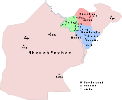 Map of the three districts which constitute Nineveh plains overlaid over the Ninawa Governorate map.
|
||
| Largest city | Bakhdida | |
| Official languages | Syriac, Ezdiki | |
| Government | ||
| • | Governor of Hamdaniya | Nisan Karromi |
| • | Governor of Tel Keppe | Basim Ballu |
| • | Governor of Al-Shikhan | Hasu Narmu |
| Area | ||
| • | Total | 4,197 km2 1,620 sq mi |
| Population | ||
| • | 2012 estimate | 500,000 |
| • | 1987 census | 281,829 |
| • | Density | 117/km2 303/sq mi |
Nineveh plains (Syriac: ܦܩܥܬܐ ܕܢܝܢܘܐ, Pqata d'Ninwĕ, and modern Syriac: ܕܫܬܐ ܕܢܝܢܘܐ, Daŝta d'Ninwĕ; Arabic: سهل نينوى, sahl naynawā; Central Kurdish: Deşta Neynewa) is a region in Iraq's Nineveh Governorate to the north and east of the city Mosul, from which it is also known as the Plain of Mosul. It was formerly known as the Plain of Sanjar or Sinjar from its major medieval settlement. It was the location of al-Khwārizmī's determination of a degree during the reign of the caliph al-Mamun. The area also includes the ruins of the ancient Assyrian cities of Nineveh, Nimrud, and Dur-Sharrukin as well as numerous ancient religious sites such as Mar Mattai Monastery, Rabban Hormizd Monastery, the Tomb of Nahum, and Lalish.[1]
Location
Nineveh Plain lies to the east, northeast of the city of Mosul in the Iraqi Ninawa Province. Although the actual ancient city of Nineveh is to be found in the eastern part of Mosul, on the bank of the Tigris river, the villages that are inhabited by minority religious groups that are non-Muslim lie to the east. Most of these inhabitants are Assyrian Christians. The Nineveh plains are not only the historical homeland of the Assyrian people and a crucible of pre-Arab and Kurd pre-Islamic Mesopotamian civilisation, but it is a province where a majority of the population is currently drawn from the minorities, around half of whom are Assyrians.[2]
History
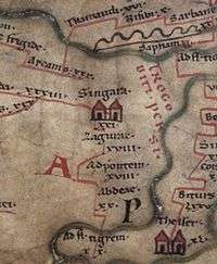
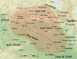
Peutinger's map of the inhabited world known to the Roman geographers depicts Singara as located west of the Trogoditi. Persi. (Latin: Troglodytae Persiae, "Persian troglodytes") who inhabited the territory around Mount Sinjar. By the medieval Arabs, most of the plain was reckoned as part of the province of Diyār Rabīʿa, the "abode of the Rabīʿa" tribe. The plain was the site of the determination of the degree by al-Khwārizmī and other astronomers during the reign of the caliph al-Mamun.[3] Sinjar also boasted a famous Assyrian cathedral in the 8th century.[4]
Attacks on Christians
Following the concerted attacks on Assyrian Christians in Iraq, especially highlighted by the Sunday, August 1, 2004 simultaneous bombing of six Churches (Baghdad and Mosul) and subsequent bombing of nearly thirty other churches throughout the country, Assyrian leadership, internally and externally, began to regard the Nineveh Plain as the location where security for Christians may be possible. Schools especially received much attention in this area and in Kurdish areas where Assyrian concentrated population lives. In addition, agriculture and medical clinics received financial help from the Assyrian diaspora.
As attacks on Christians increased in Basra, Baghdad, Ramadi and smaller towns. more families turned northward to the extended family holdings in the Nineveh Plain. This place of refuge remains underfunded and gravely lacking in infrastructure to aid the ever-increasing internally displaced people population.
In February 2010, the attacks against Assyrians in Mosul forced 4,300 Assyrians to flee to the Nineveh plains where there is an Assyrian-majority population.[5] From 2012, it also began receiving influxes of Assyrians from Syria owing to the civil war there.[6][7]
In August 2014 nearly all of the non-Sunni inhabitants of the southern regions of the Plains were driven out by the Islamic State of Iraq and the Levant during the 2014 Northern Iraq offensive.[8]
Creation of an Assyrian autonomous province
The Assyrian-inhabited towns and villages on the Nineveh Plain form a concentration of those belonging to Syriac Christian traditions, and since this area is the ancient home of the Assyrian empire through which the Assyrian people trace their cultural heritage, the Nineveh Plain is the area on which an effort to form an autonomous Assyrian entity has become concentrated. There have been calls by some politicians inside and outside Iraq to create an autonomous region for Assyrian Christians in this area.[9][10]
In the Transitional Administrative Law adopted in March 2004 in Baghdad, not only were provisions made for the preservation of Assyrian culture through education and media, but a provision for an administrative unit also was accepted. Article 125 in Iraq's Constitution states that: "This Constitution shall guarantee the administrative, political, cultural, and educational rights of the various nationalities, such as Turkomen, Chaldeans, Assyrians, and all other constituents, and this shall be regulated by law."[11][12] Since the towns and villages on the Nineveh Plain form a concentration of those belonging to Syriac Christian traditions, and since this area is the ancient home of the Assyrian empire through which these people trace their cultural heritage, the Nineveh Plain is the area on which the effort to form an autonomous Assyrian entity have become concentrated.
On January 21, 2014, the Iraqi government had declared that Nineveh Plains would become a new province, which would serve as a safe haven for Assyrians.[13]
Population
The Nineveh Plains is the only region in Iraq where the largest segment of the inhabitants follow Syriac Christianity. Before ISIS invaded Nineveh, Assyrians made up 40% of the population within the plains. [14] The five patriarchal churches represented are:[15]
- Ancient Church of the East
- Assyrian Church of the East
- Chaldean Catholic Church
- Syriac Catholic Church
- Syriac Orthodox Church
The area is considered by its Assyrian inhabitants as being the original Assyrian heartland. Other inhabitants are the Yazidis, Shabaks, Turkmens and Kurds.
Economy
The Nineveh Plain appears to hold under its rich agricultural lands an extension of the petroleum fields tapped in 2006 by the Kurdish Regional Government in direct contract with foreign oil exploration companies. It is believed that this added incentive for absorption by the KRG of the region may lead to economic conflict with Sunni Arab tribes in the Mosul region itself. Assyrians claim that without Nineveh Plain autonomous administration, the indigenous Assyrian presence in its ancient homeland could well disappear. There are some oil reserves in Nineveh Plains.[16][17]
Main towns in Nineveh plains
- Ba'adra
- Tel Kepe
- Bakhdida
- Ba'ashiqah/Bahzani
- Bartella
- khatarah
- Alqosh
- Karemlesh
- Ain Sifni
- Mahda
- Tesqopa
- Batnaya
- Baqofah
- Sharafiya
- Merki
- sresheke
See also
- Êzidixan in Iraq
- Assyrians in Iraq
- Assyrian independence
- Assyrian homeland
- Proposals for an Assyrian autonomy or state
- Barwari
- Nahla plains
- Urmia Plain
- Ezidkhan
Notes
- ↑ http://abcnews.go.com/International/wireStory/iraq-hangs-26-convicted-terror-charges-21606806
- ↑ Mardean Isaac (2010-12-30). "The desperate plight of Iraq's Assyrians and other minorities | Mardean Isaac | Comment is free | guardian.co.uk". Guardian. Retrieved 2012-08-17.
- ↑ Abul Fazl-i-Ạllámí (1894), "Description of the Earth", The Áin I Akbarí, Vol. III, Translated by H.S. Jarrett, Calcutta: Baptist Mission Press for the Asiatic Society of Bengal, p. 25–27.
- ↑ A short history of Syriac literature. Retrieved 23 December 2014.
- ↑ UN report.
- ↑ http://www.assyrianaidiraq.org/relief_projects
- ↑ http://www.assyrianaid.org/Refugees2012.html
- ↑ Chulov, Martin; Hawramy, Fazel (9 August 2014). "'Isis has shattered the ancient ties that bound Iraq's minorities'". The Guardian. Retrieved 11 August 2014.
- ↑ Iraqi Christians hold critical meeting, The Kurdish Globe
- ↑ Dutch MP calls for autonomous Assyrian Christian region in north Iraq, AKI
- ↑ http://www.assyrianamericancoalition.org/documents/policy/AtTheTippingPoint-NPProvinceSolutionFull.pdf
- ↑ "Iraq Sustainable Democracy Project". Iraqdemocracyproject.org. 2008-02-19. Retrieved 2012-08-17.
- ↑
- ↑ http://rudaw.net/english/middleeast/iraq/24012014
- ↑ http://yonoforiraq.com/AboutMosul.pdf
- ↑ http://www.religiousfreedomcoalition.org/2011/02/21/christian-leaders-unhappy-with-lack-of-action-on-nineveh-plain/
- ↑ https://iwpr.net/global-voices/kurdistans-gushing-crude-spawns-conflict
References
Coordinates: 36°37′N 43°7′E / 36.617°N 43.117°E
Nineveh plains region in northern Iraq | ||||||||||||
|---|---|---|---|---|---|---|---|---|---|---|---|---|
| Main settlements |  | |||||||||||
| Archaeological sites | ||||||||||||
| Religious sites |
| |||||||||||