Jezreel Valley

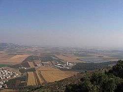
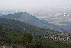
The Jezreel Valley (Hebrew: עמק יזרעאל, translit. Emek Yizra'el), (Arabic: مرج إبن عامر "Marj Ibn Āmir") is a large fertile plain and inland valley south of the Lower Galilee region in Israel. The Samarian highlands and Mount Gilboa border the valley from the south and to the north lie the Israeli cities Afula and Tiberias. To the west is the Mount Carmel range, and to the east is the Jordan Valley.
Etymology
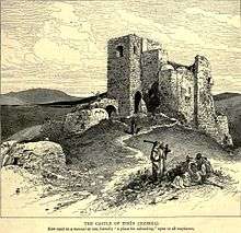
The Jezreel Valley takes its name from the ancient city of Jezreel (known in Arabic as Zir'ēn; Arabic: زرعين) which was located on a low hill overlooking the southern edge of the valley. The word Jezreel comes from the Hebrew, and means "God sows" or "El sows".[1] The phrase "valley of Jezreel" was sometimes used to refer to the central part of the valley, around the city of Jezreel, while the southwestern portion was known as the "valley of Megiddo", after the ancient city of Megiddo, which was located there. The area has been known as the Plain of Esdraelon (Esdraelon is the Koine Greek rendering of Jezreel).
Geography
The valley perhaps once acted as the channel by which the Dead Sea, located southeast of the valley, connected to the Mediterranean Sea. About two million years ago, as the land between the Mediterranean Sea and the Jordan Rift Valley rose, this connection was lost, and periodic floods from the Mediterranean Sea ceased. This resulted in the Dead Sea no longer having a connection to the ocean, and over time, due to greater evaporation than precipitation plus surface water inflow, it has become heavily saline.
History
Biblical
Biblical cities in the Jezreel Valley include Jezreel, Megiddo, Beit She'an Shimron and Afula. Archaeological excavations have indicated near continuous settlement from the Ghassulian culture of the Chalcolithic Age (c. 4500–3300 BCE) to the Ayyubid periods of the 11–13th centuries.[2]
The valley formed an easier route through the Levant than crossing the mountains on either side, and so saw a large amount of traffic, and was the site of many historic battles; the earliest battle for which, the Battle of Megiddo, has a surviving detailed account to prove that it was fought in the valley. Due to the surrounding terrain, Egyptian chariots were only able to travel from Egypt as far as the Jezreel valley and the valley north of Lake Huleh.
According to the Bible, the valley was the scene of a victory by the Israelites, led by Gideon, against the Midianites, the Amalekiltes, and the Children of the East,[3] but was later the location at which the Israelites, led by King Saul, were defeated by the Philistines.[4] According to textual scholars, the account of an ancient Philistine victory at Jezreel derives from the monarchial source, in contrast to the republican source, which places the Philistine victory against the Israelites at Mount Gilboa.[5][6] In Christian eschatology, the part of the valley on which the Battle of Megiddo was fought is believed to be the destined site of the penultimate battle between good and evil (the final battle taking place 1,000 years later in Jerusalem),[7] known as Armageddon (a word derived from Megiddo).
According to 2Kings 9:1–10, after Jehu kills King Jehoram, he confronts Jezebel in Jezreel and urges her eunuchs to kill Jezebel by throwing her out of a window. They comply, tossing her out the window and leaving her in the street to be eaten by dogs. Only Jezebel's skull, feet, and hands remained.
Ottoman era
In 1852 the American writer Bayard Taylor traveled across the Jezreel Valley, which he described in his 1854 book 'The Lands of the Saracen; or, Pictures of Palestine, Asia Minor, Sicily and Spain' as: "one of the richest districts in the world."[8] Laurence Oliphant, who visited the 'Akko Sanjak' valley area in 1887, then a subprovince of the 'Beirut Wilayah',[9] wrote that the Valley of Esdraelon (Jezreel) was "a huge green lake of waving wheat, with its village-crowned mounds rising from it like islands; and it presents one of the most striking pictures of luxuriant fertility which it is possible to conceive."[10]
In the 1870s, the Sursock family of Beirut (present-day Lebanon) purchased the land from the Ottoman government for approximately £20,000. Between 1912 and 1925 the Sursock family (then under the French Mandate of Syria) sold their 80,000 acres (320 km²) of land in the Vale of Jezreel to the American Zion Commonwealth for about nearly three-quarters of a million pounds. The land was purchased by the Jewish organization as part of an effort to resettle Jews who inhabited the land, as well as others who came from distant lands[11] and the Jewish National Fund.[12]
British Mandate
After the land was sold to the American Zion Commonwealth, some of the Arab farmers who lived in nearby villages and had been working for the absentee landowners were evicted. Despite the sale, some of the farmers refused to leave their land, as in Afula (El-Ful),[13] however the new owners decided that it would be inappropriate for these farmers to remain as tenants on land intended for Jewish labor. This was a commonplace feeling among the Jewish residents, part of a socialist ideology of the Yishuv, which included their working the land rather than being absentee landowners. British police had to be used to expel some and the dispossessed made their way to the coast to search for new work with most ending up in shanty towns on the edges of Jaffa and Haifa.[14]

Following the purchase of the land, the Jewish farmers created the first modern-day settlements, founded the modern day city of Afula and drained the swamps to enable further land development of areas that had been uninhabitable for centuries. The first moshav, Nahalal, was settled in this valley on 11 September 1921.
After the widespread Arab riots of 1929 in the then British Mandate of Palestine, the Hope Simpson Royal Commission was appointed to seek causes and remedies for the instability. The Commission's findings in regard to "Government responsibility towards Arab cultivators", was that the Jewish authorities "have nothing with which to reproach themselves" in the purchase of the valley, noting the high prices paid and land occupants receiving compensation not legally bound. The responsibility of the Mandate Government for "soreness felt (among both effendi and fellahin) owing to the sale of large areas by the absentee Sursock family" and the displacement of Arab tenants; noted that, "the duty of the Administration of Palestine to ensure that the rights and position of the Arabs are not prejudiced by Jewish immigration. It is doubtful whether, in the matter of the Sursock lands, this Article of the Mandate received sufficient consideration."[15]
State of Israel
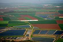
The Jezreel Valley is a green fertile plain covered with fields of wheat, watermelon, melon, oranges, white beans, cowpeas, chickpeas, green beans, cotton, sunflowers and corn, as well as grazing tracts for multitudes of sheep and cattle. The area is governed by the Jezreel Valley Regional Council. The Max Stern College of Emek Yizreel and the Emek Medical Center are located in the valley. In 2006, the Israeli Transportation Ministry and Jezreel Valley Regional Council announced plans to build an international airport near Megiddo but the project was shelved due to environmental objections.[16]
Archaeological excavations
Archaeological sites in the Jezreel Valley are currently excavated and coordinated by the Jezreel Valley Regional Project.[17] Excavations include the Ein el-Jarba site.
See also
- Battle of Ain Jalut, major battle in 1260 between the Mongols and the Mamluks.
- Dead Sea
- Jezreel Valley Regional Council
References
- ↑ Cheyne and Black, Encyclopedia Biblica
- ↑ Israel Handbook by Dave Winter, Footprint Travel Guides, ISBN 0-658-00368-2 (
- ↑ Judges 6:3
- ↑ 1 Samuel 29:1–6
- ↑ 1 Samuel 28:4
- ↑ 1 Samuel 31:1–6
- ↑ Eric H. Cline, Assistant Director US, Tel Megiddo Expedition
- ↑ Bayard Taylor. (3 February 2004). "The Lands of the Saracen, by Bayard Taylor". Gutenberg.org. Retrieved 24 March 2013.
- ↑ "Palestinim, Am Behivatsrut," by Kimmerling, Baruch, and Joel S. Migdal – Keter Publishing, ISBN 965-07-0797-2
- ↑ Abu-Lughod, Ibrahim (1971). (Ed)., The Transformation of Palestine. Illinois: Northwestern Press. p. 126.
- ↑ Safarix.com, pg. 49
- ↑ "Via Maris, by Avi Hein". Jewish Virtual Library. Retrieved 24 March 2013.
- ↑ "Buying the Emek by Arthur Ruppin, 1929 (with an introduction)". Zionism-israel.com. Retrieved 24 March 2013.
- ↑
- Nevill Barbour: Nisi Dominus: A Survey of the Palestine Controversy. George G. Harrap, London 1946, pp. 117–118
- Polk, Stamler, Asfour: Backdrop to Tragedy: The Struggle for Palestine. Beacon Press, Boston, 1957, pp. 237–238.
- ↑ Palestine. Report on Immigration, Land Settlement and Development. By Sir John Hope Simpson, C.I.E.
- Chapter 1.3: Palestine: The Country and the Climate; 3)The vale of Esdraelon,
- Chapter 5.3: Jewish Settlement on the Land; 3)The effect of Jewish settlement on the Arab
- ↑ http://fr.jpost.com/servlet/Satellite?cid=1245184871151&pagename=JPost/JPArticle/ShowFull
- ↑ "Home". jezreelvalleyregionalproject.com. Retrieved 19 January 2015.
External links
| Wikimedia Commons has media related to Jezreel Valley. |
- Jezreel Valley College
- Emek Medical Center
- Jezreel Valley Regional Council official website (in Hebrew)
- Jezreel Valley Regional Project
-
 Chisholm, Hugh, ed. (1911). "Jezreel". Encyclopædia Britannica (11th ed.). Cambridge University Press.
| Districts |  | |
|---|---|---|
| Bodies of water | ||
| Occupied territories | ||
| Cities | ||
| Regions | ||
| Bordering nations | ||
| Archaeology | ||
32°35′47″N 35°14′31″E / 32.59639°N 35.24194°ECoordinates: 32°35′47″N 35°14′31″E / 32.59639°N 35.24194°E