Piz Nair (Glarus Alps)
| Piz Nair | |
|---|---|
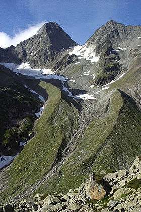 Piz Nair (left) and Hälsistock (right) from the Etzli valley | |
| Highest point | |
| Elevation | 3,059 m (10,036 ft) |
| Prominence | 229 m (751 ft) [1] |
| Parent peak | Piz Giuv |
| Coordinates | 46°41′57.2″N 8°42′32.8″E / 46.699222°N 8.709111°ECoordinates: 46°41′57.2″N 8°42′32.8″E / 46.699222°N 8.709111°E |
| Geography | |
 Piz Nair Location in Switzerland | |
| Location | Graubünden/Uri, Switzerland |
| Parent range | Glarus Alps[2] |
Piz Nair (3,059 m) is a mountain of the Glarus Alps, located on the border between the Swiss cantons of Uri and Graubünden. Together with Piz Giuv (3,096 m) on the west, it overlooks the end of the Etzli valley in the canton of Uri. The south-west and the south-east sides overlook respectively the small valleys of Val Giuv and Val Milà, both converging to the Rhine valley west of Sedrun (Graubünden). The mountain is politically divided between the municipalities of Silenen (Uri) and Tujetsch (Graubünden).
On the northern side of Piz Nair lies a small glacier, the Fellelifirn. Large lateral moraines can be seen below the glacier.
References
This article is issued from Wikipedia - version of the 1/3/2016. The text is available under the Creative Commons Attribution/Share Alike but additional terms may apply for the media files.