Piz Linard
| Piz Linard | |
|---|---|
|
View of Piz Linard from the Engadine valley (south) | |
| Highest point | |
| Elevation | 3,410 m (11,190 ft) |
| Prominence | 1,027 m (3,369 ft) [1] |
| Isolation | 24.9 km (15.5 mi) [2] |
| Parent peak | Piz Kesch |
| Listing | List of mountains of Switzerland |
| Coordinates | 46°47′56″N 10°04′17″E / 46.79889°N 10.07139°ECoordinates: 46°47′56″N 10°04′17″E / 46.79889°N 10.07139°E |
| Geography | |
 Piz Linard Location in Switzerland | |
| Location | Graubünden, Switzerland |
| Parent range | Silvretta Alps |
| Climbing | |
| First ascent | August 1, 1835 by Oswald Heer and Johann Madutz |
| Easiest route | Scramble |

Piz Linard is a pyramid-shaped mountain of the Swiss Alps. At 3,410 m it is the highest peak of the Silvretta mountain range.
It was first climbed on August 1, 1835 by the geologist and naturalist Oswald Heer led by Johann Madutz.
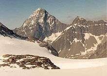
Piz Linard from the North in July 1986
There is a legend that a man of name "Chounard" reached the summit in 1572 carrying a large golden cross, however the cross has never been found.
Piz Linard is located between the valleys of Val Lavinuoz (east) and Val Saglains (west), both part of the basin of the Inn river in the Engadine valley.
See also
References
- ↑ Retrieved from the Swisstopo maps. The key col is the Albula Pass (2,383 m).
- ↑ Retrieved from Google Earth. The nearest point of higher elevation is Piz Kesch.
External links
| Wikimedia Commons has media related to Piz Linard. |
This article is issued from Wikipedia - version of the 2/15/2016. The text is available under the Creative Commons Attribution/Share Alike but additional terms may apply for the media files.