Piz Curvér
| Piz Curvér | |
|---|---|
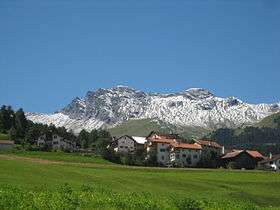 View from Riom-Parsonz | |
| Highest point | |
| Elevation | 2,972 m (9,751 ft) |
| Prominence | 456 m (1,496 ft) |
| Parent peak | Piz Grisch |
| Coordinates | 46°36′12.6″N 9°29′49.4″E / 46.603500°N 9.497056°ECoordinates: 46°36′12.6″N 9°29′49.4″E / 46.603500°N 9.497056°E |
| Geography | |
 Piz Curvér Location in Switzerland | |
| Location | Graubünden, Switzerland |
| Parent range | Oberhalbstein Range |
Piz Curvér is a mountain of the Oberhalbstein Range, between Andeer and Savognin, in the canton of Graubünden. With a height of 2,972 metres (9,751 ft) above sea level, it is the highest point of the chain north of the pass Fuorcla Cotschna. On its eastern flank lies the holy pilgrimage site of Ziteil, at 2,434 metres (7,986 ft) above sea level.
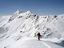
View of Piz Curvér from Piz Toissa
External links
| Wikimedia Commons has media related to Piz Curvér. |
This article is issued from Wikipedia - version of the 5/8/2016. The text is available under the Creative Commons Attribution/Share Alike but additional terms may apply for the media files.