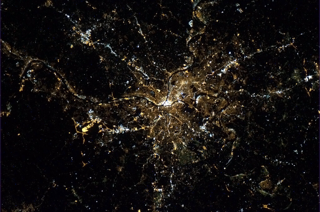
Pittsburgh metropolitan area
| Greater Pittsburgh Pittsburgh – New Castle - Weirton, PA-WV-OH CSA Pittsburgh, PA MSA Southwestern Pennsylvania Upper Ohio Valley Pittsburgh Tri-State Area | |
|---|---|
| Combined Statistical Area | |
|
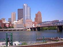
Downtown Pittsburgh seen from the University of Pittsburgh | |
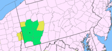
 Map of metro area (MSA in green, CSA in yellow) | |
| Country |
|
| States |
|
| Largest city |
|
| Area | |
| • Metro | 14,780 km2 (5,706 sq mi) |
| Highest elevation | 915 m (3,001 ft) |
| Lowest elevation | 200 m (660 ft) |
| Population (2012/2010)[1] | |
| • Density | 166/km2 (429/sq mi) |
| • Urban | 1,733,853(22nd) |
| • MSA | 2,353,045(22nd) |
| • CSA | 2,648,605 (19th) |
|
MSA/CSA = 2012, Urban = 2010 | |
| Time zone | EST (UTC-5) |
| • Summer (DST) | EDT (UTC-4) |
| ZIP codes | 15001 to 16199 |
| Area code(s) | 304, 330, 412, 681, 724, 740, 814, 878 |
The Pittsburgh metropolitan area (also called Greater Pittsburgh, Southwestern Pennsylvania or the Pittsburgh Tri-State)[2] is the largest population center in both the Ohio River Valley and Appalachia. The metropolitan area consists of the City of Pittsburgh in the Commonwealth of Pennsylvania and surrounding counties. By many definitions the area extends into the U.S. states of West Virginia and Ohio.[3][4][5] The larger "tri-state" region is defined by the U.S. Census as the combined statistical area (CSA) while definitions of the metropolitan statistical area (MSA) are within Pennsylvania.[6]
The area is renowned for its industries including steel, glass and oil; its economy also thrives on healthcare, education, technology, robotics, financial services and the film industry. The region is an emergent area for oil and natural gas companies' Marcellus shale production.[7] The city is headquarters to major global financial institutions including PNC Financial Services (the nation's fifth-largest bank), Federated Investors and the regional headquarters of BNY Mellon. The region is also the 21st largest port in the United States with almost 34 million short tons of river cargo for 2011, the port ranked 9th largest in the U.S. when measured in domestic trade.[8] Since 1954 suburban Boyers, Pennsylvania has been home to one of the world's largest archives including CORBIS images, and Federal documents, since 1998 Iron Mountain Incorporated has used the complex as its main facility.
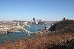
_from_the_air.jpg)
Definition
The U.S. Census Bureau defines the area as both an MSA consisting of seven Western Pennsylvania counties anchored by the City of Pittsburgh and a twelve county Pittsburgh–New Castle-Weirton CSA with 2 West Virginia counties and one in Ohio. The MSA definition includes the city proper and the Pennsylvania counties of Allegheny, Armstrong, Beaver, Butler, Fayette, Washington, and Westmoreland. The CSA definition also adds the two Western Pennsylvania counties of Lawrence and Indiana, West Virginia's Brooke and Hancock as well as Ohio's Jefferson.
The MSA had a 2012 population of 2,360,733[9] and has a land area of 5,343 sq. miles, while the CSA had a 2012 population of 2,661,369.[10] Pittsburgh is part of the Great Lakes Megalopolis containing an estimated 54 million people, while many residents also consider themselves part of the Mid-Atlantic coastal region of Virginia to New York. It is classified as Northeast by the U.S. Census with the West Virginia and Ohio components of the CSA being classified as South and Mid-west respectively.[11] The entire MSA and CSA are within the Congressional Appalachian Regional Commission's definition of Appalachia.
The area's media market extends to 15 counties in Pennsylvania, Maryland and West Virginia. The region is also sometimes defined as reaching into the southwestern New York State county of Chautauqua the western Maryland counties of Garrett and Allegany as well as the majority of West Virginia, all of Western Pennsylvania and the east-central counties of Ohio.[12][13][14]
History of definition
Population
| Year | MSA Population | CSA Population | ||
|---|---|---|---|---|
| 1900 | 1,303,771 | - | - | - |
| 1910 | 1,779,718 | 36.51% | - | - |
| 1920 | 2,100,931 | 18.05% | - | - |
| 1930 | 2,381,589 | 13.36% | - | - |
| 1940 | 2,452,232 | 2.97% | - | - |
| 1950 | 2,581,297 | 5.26% | - | - |
| 1960 | 2,768,938 | 7.27% | - | - |
| 1970 | 2,759,443 | -0.34% | - | - |
| 1980 | 2,651,991 | -3.89% | - | - |
| 1990 | 2,468,289 | -6.93% | 2,564,535 | - |
| 2000 | 2,431,087 | -1.51% | 2,525,730 | -1.51% |
| 2010 | 2,356,285 | -3.1% | 2,660,840 | 5.35% |
| 2012 (est.) | 2,360,733 | 0.19% | 2,662,822 | 0.07% |
Since the U.S. Census officially began "metropolitan" definitions in 1950, the original counties included were: Allegheny, Westmoreland, Washington and Beaver.[15]
In 1983 Fayette County was added, in 1993 Butler County was added, in 2003 Armstrong County was added with Lawrence County as a combined area.[16]
2013 saw the combined area grow as both Indiana County, Pennsylvania was added and the counties of Jefferson in Ohio and Brooke and Hancock in West Virginia were added.[6]
The Regional Industrial Development agency (RIDC) has worked across county lines as early as 1967.[17]
Foreign Trade Zones (FTZs) #33 and #254 cover the area.[18] with the RIDC managing the centrally located FTZ #33.[19]
Communities
Cities
- Adena, Ohio (CSA)
- Aliquippa
- Amsterdam, Ohio (CSA)
- Arnold
- Beaver Falls
- Beech Bottom, West Virginia (CSA)
- Bergholz, Ohio (CSA)
- Bethany, West Virginia (CSA)
- Bloomingdale, Ohio (CSA)
- Butler
- Chester, West Virginia (CSA)
- Clairton
- Connellsville
- Dillonvale, Ohio (CSA)
- Duquesne
- Empire, Ohio (CSA)
- Follansbee, West Virginia (CSA)
- Greensburg
- Hooverson Heights, West Virginia (CSA)
- Indiana, Pennsylvania (CSA)
- Irondale, Ohio (CSA)
- Jeannette
- Latrobe
- Lower Burrell
- McKeesport
- Mingo Junction, Ohio (CSA)
- Monessen
- Monongahela
- Mount Pleasant, Ohio (CSA)
- New Alexandria, Ohio (CSA)
- New Castle (CSA)
- New Cumberland, West Virginia (CSA)
- New Kensington
- Newell, West Virginia (CSA)
- Parker
- Pittsburgh (Principal city)
- Rayland, Ohio (CSA)
- Richmond, Ohio (CSA)
- Smithfield, Ohio (CSA)
- Steubenville, Ohio (CSA)
- Stratton, Ohio (CSA)
- Tiltonsville, Ohio (CSA)
- Toronto, Ohio (CSA)
- Uniontown
- Washington
- Wellsburg, West Virginia (CSA)
- Weirton, West Virginia (CSA)
- Wintersville, Ohio (CSA)
- Yorkville, Ohio (CSA)
Boroughs
- Adamsburg
- Allenport
- Ambridge
- Apollo
- Applewold
- Arona
- Aspinwall
- Atwood
- Avalon
- Avonmore
- Baden
- Baldwin
- Beallsville
- Beaver
- Bell Acres
- Belle Vernon
- Bellevue
- Ben Avon Heights
- Ben Avon
- Bentleyville
- Bethel Park
- Big Beaver
- Blawnox
- Bolivar
- Brackenridge
- Braddock Hills
- Braddock
- Bradford Woods
- Brentwood
- Bridgeville
- Bridgewater
- Brownsville
- Bruin
- Burgettstown
- California
- Callery
- Canonsburg
- Carnegie
- Castle Shannon
- Centerville
- Chalfant
- Charleroi
- Cherry Valley
- Cheswick
- Chicora
- Churchill
- Claysville
- Coal Center
- Cokeburg
- Connoquenessing
- Conway
- Coraopolis
- Crafton
- Darlington
- Dawson
- Dayton
- Deemston
- Delmont
- Derry
- Donegal
- Donora
- Dormont
- Dravosburg
- Dunbar
- Dunlevy
- East Butler
- East McKeesport
- East Pittsburgh
- East Rochester
- East Vandergrift
- East Washington
- Eastvale
- Eau Claire
- Economy
- Edgewood
- Edgeworth
- Elco
- Elderton
- Elizabeth
- Ellsworth
- Ellwood City
- Emsworth
- Etna
- Evans City
- Everson
- Export
- Fairchance
- Fairview
- Fallston
- Fayette City
- Finleyville
- Ford City
- Ford Cliff
- Forest Hills
- Fox Chapel
- Frankfort Springs
- Franklin Park
- Freedom
- Freeport
- Georgetown
- Glasgow
- Glassport
- Glenfield
- Green Hills
- Green Tree
- Harmony
- Harrisville
- Haysville
- Heidelberg
- Homestead
- Homewood
- Hookstown
- Houston
- Hunker
- Hyde Park
- Industry
- Ingram
- Irwin
- Jefferson Hills
- Karns City
- Kittanning
- Koppel
- Laurel Mountain
- Leechburg
- Leetsdale
- Liberty
- Ligonier
- Lincoln
- Long Branch
- Madison
- Manor
- Manorville
- Marianna
- Markleysburg
- Mars
- Masontown
- McDonald
- McKees Rocks
- Midland
- Midway
- Millvale
- Monaca
- Monroeville
- Mt. Oliver
- Mt. Pleasant
- Munhall
- Murrysville
- New Alexandria
- New Brighton
- New Eagle
- New Florence
- New Galilee
- New Stanton
- Newell
- North Apollo
- North Belle Vernon
- North Braddock
- North Charleroi
- North Irwin
- Oakdale
- Oakmont
- Ohiopyle
- Ohioville
- Oklahoma
- Osborne
- Patterson Heights
- Penn
- Pennsbury Village
- Perryopolis
- Petrolia
- Pitcairn
- Pleasant Hills
- Plum
- Point Marion
- Port Vue
- Portersville
- Prospect
- Rankin
- Rochester
- Roscoe
- Rosslyn Farms
- Rural Valley
- Saxonburg
- Scottdale
- Seven Fields
- Seven Springs
- Seward
- Sewickley Heights
- Sewickley Hills
- Sewickley
- Sharpsburg
- Shippingport
- Slippery Rock
- Smithfield
- Smithton
- South Bethlehem
- South Connellsville
- South Greensburg
- South Heights
- Southwest Greensburg
- Speers
- Springdale
- Stockdale
- Sutersville
- Swissvale
- Tarentum
- Thornburg
- Trafford
- Turtle Creek
- Twilight
- Valencia
- Vanderbilt
- Vandergrift
- Verona
- Versailles
- Wall
- West Brownsville
- West Elizabeth
- West Homestead
- West Kittanning
- West Leechburg
- West Liberty
- West Mayfield
- West Middletown
- West Mifflin
- West Newton
- West Sunbury
- West View
- Whitaker
- White Oak
- Whitehall
- Wilkinsburg
- Wilmerding
- Worthington
- Youngstown
- Youngwood
- Zelienople
Census-designated places
Note: All census-designated places are unincorporated.
- Baidland
- Calumet-Norvelt
- Carnot-Moon
- Cecil-Bishop
- Crabtree
- Curtisville
- East Uniontown
- Fernway
- Fox Run
- Fredericktown-Millsboro
- Gastonville
- Grapeville
- Grindstone-Rowes Run
- Harrison City
- Herminie
- Hiller
- Homeacre-Lyndora
- Hopwood
- Imperial-Enlow
- Lawson Heights
- Leith-Hatfield
- Lenape Heights
- Lynnwood-Pricedale
- McChesneytown-Loyalhanna
- McGovern
- McMurray
- Meadowood
- Meridian
- New Salem-Buffington
- Nixon
- North Vandergrift-Pleasant View
- Oak Hills
- Oliver
- Orchard Hills
- Republic
- Russellton
- Shanor-Northvue
- Slickville
- Sturgeon-Noblestown
- Thompsonville
- West Hills
- Wickerham Manor-Fisher
- Wolfdale
Townships
Allegheny County Townships
- Aleppo
- Baldwin
- Collier
- Crescent
- East Deer
- Elizabeth
- Fawn
- Findlay
- Forward
- Frazer
- Hampton
- Harmar
- Harrison
- Indiana
- Kennedy
- Kilbuck
- Leet
- Marshall
- McCandless
- Moon
- Mt. Lebanon
- Neville
- North Fayette
- North Versailles
- O'Hara
- Ohio
- Penn Hills
- Pine
- Reserve
- Richland
- Robinson
- Ross
- Scott
- Shaler
- South Fayette
- South Park
- South Versailles
- Springdale
- Stowe
- Upper St. Clair
- West Deer
- Wilkins
Armstrong County Townships
Beaver County Townships
Butler County Townships
Fayette County Townships
Washington County Townships
- Amwell
- Blaine
- Buffalo
- Canton
- Carroll
- Cecil
- Chartiers
- Cross Creek
- Donegal
- East Bethlehem
- East Finley
- Fallowfield
- Hanover
- Hopewell
- Independence
- Jefferson
- Morris
- Mount Pleasant
- North Bethlehem
- North Franklin
- North Strabane
- Nottingham
- Peters
- Robinson
- Smith
- Somerset
- South Franklin
- South Strabane
- Union
- West Bethlehem
- West Finley
- West Pike Run
Westmoreland County Townships
Demographics
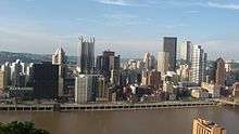
_seen_from_the_Cathedral_of_Learning_May_14%2C_2010.jpg)
As of the census[20] of 2000, there were 2,431,087 people, 995,505 households, and 652,196 families residing within the MSA. The racial makeup of the MSA was 89.8% (2,182,444) White, 7.9% (191,103) African American, 0.1% (2,668) Native American, 1.1% (26,209) Asian, <0.1% (552) Pacific Islander, 0.3% (6,250) from other races, and 0.9% (21,861) from two or more races. 0.7% (17,408) were Hispanic or Latino of any race.
The median income for a household in the MSA was $35,908, and the median income for a family was $44,709. Males had a median income of $35,670 versus $23,993 for females. The per capita income for the MSA was $18,897.
As of the census[20] of 2000, there were 2,525,730 people, 1,032,596 households, and 678,085 families residing within the CSA. The racial makeup of the CSA was 90.0% (2,272,338) White, 7.7% (194,519) African American, 0.1% (2,763) Native American, 1.1% (26,467) Asian, <0.1% (561) Pacific Islander, 0.3% (6,426) from other races, and 0.9% (22,656) from two or more races. 0.7% (17,937) were Hispanic or Latino of any race.
The median income for a household in the CSA was $35,563, and the median income for a family was $44,303. Males had a median income of $35,277 versus $23,713 for females. The per capita income for the CSA was $18,639.
Transportation
Airports
Pittsburgh International Airport (IATA: PIT) is located 17 miles (27 km) to the west of downtown Pittsburgh in Findlay.[21] The smaller but less crowded Arnold Palmer Regional Airport (IATA: LBE) to the east of downtown in Latrobe provide commercial service to the metro area.
Pittsburgh International was the fortress hub of US Airways from 1952 to 2005 with over 500 daily departures to more than 110 destinations in 2000. By 2007, fewer than 70 departures to 21 destinations remained.[22] In 2007, US Airways did select the airport for its new $25 million, 27,000 sq ft (2,500 m2), 600-employees-strong Global Flight Operations Center. Since being de-hubbed the airport has seen expanded service from JetBlue, Southwest Airlines and Delta Air Lines' direct trans-Atlantic service to Paris.
Arnold Palmer Regional Airport offers commercial service via Spirit Airlines to the Carolinas, Florida and Texas. Palmer has had commercially scheduled air service since the 1980s.
Allegheny County Airport (IATA: AGC) in suburban West Mifflin, Pennsylvania, is the area's largest general aviation airport. The historic landmark, art deco terminal was the main passenger airport for the area until 1952. Allegheny opened in 1931 as the nation's third largest and first with "hard surface" runways.
Smaller suburban airports serve as private plane and corporate jet bases include:
- North Metro:
- South Metro:
- East Metro:
- West Metro:
- Beaver County Airport
- Eddie Dew Memorial Airpark (Ohio)
- Jefferson County Airpark (Ohio)
- Herron Airport (West Virginia)
- Wheeling Airport (West Virginia)
Interstates
The Pittsburgh area is served by four main-line Interstates including the Pennsylvania Turnpike (which is co-signed with I-76 and in the extreme eastern part of the region also co-signed with I-70):
As well as several Interstate spur routes:
Other expressways
 US 22 serving west area commuters from Steubenville, Ohio, through West Virginia and into the metro area of Washington County, Pennsylvania, and into Allegheny merging into I-376.
 US 30 in the Greensburg area and co-signed with I-376 through the city and western suburbs.
 US 119
 US 422
 SR 7 along the Ohio River in Jefferson County, Ohio.
 PA 28 serving the Allegheny Valley commuters in the Northeast and through suburban Armstrong County.
 Toll PA 43 (Mon–Fayette Expressway) a 70 mile long interstate grade route between the south hills and West Virginia.
 PA 65 serving commuters along the Ohio River valley to the northwest of the city.
 Toll PA 66 (Amos K. Hutchinson Bypass) as a partial east hills beltway for traffic from both Interstate 70 and the Pennsylvania Turnpike/Interstate 76.
- Fort Duquesne Boulevard serving as a downtown expressway between I-279 and I-579.
Port
The Port of Pittsburgh ranks as the 21st largest port in the United States with almost 34 million short tons of river cargo for 2011, the port ranked 9th largest in the U.S. when measured in domestic trade.[8]
Mass transit
The Port Authority of Allegheny County (PAT) is the largest mass transit service in the metro area and includes a 26-mile subway/light rail system, all serving the central core. This system is complimented by BTA and Town & Country to north destinations, BCTA and NTC to northwest destinations, WCTA and IndiGo to eastern destinations, WCT, MMVTA and FACT serving southern destinations. The University of Pittsburgh Transportation System also provides services in the eastern core of the metropolitan area while Mountain Line Transit serves the city, western suburbs and an express route south to Morgantown, West Virginia.
A metro map of all fixed route transit routes for Pennsylvania counties can be found here.[23]
Rail
Amtrak serves the region with stops at Penn Station in Downtown Pittsburgh, Connellsville to the southeast and both Greensburg and Latrobe to the east.
Freight rail is a major industry for the area with the Pittsburgh Line and the Conway Yard among other infrastructure serving the region.
Interstate bus
Both the Greyhound Lines and Megabus serve the area.
Sports
The Pittsburgh area served as a launchpad for the professionalization of both American football and ice hockey in the 1890s and 1900s. The first professional player (William Heffelfinger) played for a Pittsburgh football team in 1892, which was followed by the first open professional (John Brallier), the first all-professional team (the Latrobe Athletic Association), and a participant in the first all-professional league (the Pittsburgh Stars of the first National Football League). In the case of ice hockey, the Western Pennsylvania Hockey League was the first hockey league to pay its players in 1901, eventually merging into the first fully pro league, the International Professional Hockey League, in 1904. Professional hockey in Pennsylvania predated the professionalization of the game in Canada (where it eventually came to dominate in the early 20th century) by four years.
Today, the region is home to three "major league" franchises:
- Pittsburgh Pirates in Major League Baseball (founded 1882)
- Pittsburgh Steelers in the National Football League (founded 1933)
- Pittsburgh Penguins in the National Hockey League (founded 1967)
It also has several minor league teams including:
- Washington Wildthings Independent Baseball.
- Pittsburgh Power Arena Football
- Pittsburgh Riverhounds, a professional soccer team in the United Soccer League
- Wheeling Nailers Minor League Hockey in the ECHL
College sports
NCAA Division I sports also play a key role in the region with the University of Pittsburgh and Duquesne University fielding football and basketball teams.
Robert Morris University also fields Division I basketball and football teams as well as Division I ice hockey.
Golf
Golf in the metro area boasts such courses as Oakmont Country Club, which has hosted the U.S. Open a record eight times, and Foxburg Country Club the oldest continuous club in the U.S. Such tournaments as the 84 Lumber Classic, Pittsburgh Senior Open and the current Mylan Classic call the region home. Area courses have also hosted multiple PGA Championships, LPGA Championships, U.S. Women's Opens and Ryder Cup matches.
Annual sports events
Annual sporting events include the Head of the Ohio crew race, Three Rivers Regatta, Pittsburgh Vintage Grand Prix, and the Pittsburgh Marathon.
The regions rivers have hosted the Bassmaster Classic and Forrest Wood Cup and the city has enjoyed having one of only two teams to host the Major League Baseball All Star Game a record eight times. The area has also hosted the NHL All Star Game, NHL Winter Classic, Senior Olympics, NHL Entry Draft, AHL All Star Game, NCAA Tournament and has been selected as the site of the 2012 Frozen Four.
Winter in the region sees sport continue at such rinks at PPG Place and North Park as well as area ski resorts like Boyce Park, Seven Springs Mountain Resort, Hidden Valley, Laurel Mountain and Wisp.
Education
The largest school district in the area is the Pittsburgh Public Schools with the school districts of Allegheny County also boasting large student bodies. Many private schools also serve the core county of Allegheny.
Public districts in Westmoreland, Washington,
Private Schools exist in surrounding counties such as Westmoreland, Washington,
Several Pittsburgh area colleges and universities serve the region.
Area codes
The following area codes serve the metropolitan area:
Regional identity
Pittsburgh narrowly falls within the borders of the Northeastern United States as defined by multiple agencies of the US Government, but the Pittsburgh Combined Statistical Area extends into both the Southern United States (West Virginia) and the Midwestern United States (Ohio) due to the fact that the borders of these three regions meet only 30 miles (48 km) from the city proper. Pittsburgh also belongs to the Great Lakes Megalopolis, a collection of primarily Midwestern cities like Detroit, Chicago, and Cleveland, reflecting Pittsburgh's stronger socio-economic connections to Ohio than eastern Pennsylvania.[24][25]
Pittsburgh also falls within the borders of Appalachia as defined by the Appalachian Regional Commission. The city has long been characterized as the "northern urban industrial anchor of Appalachia",[26]:167 a designation which made it an anomaly compared to much of Appalachia in the 20th century, which was traditionally characterized as southern, rural, and economically distressed.[26]:167 In its post-industrial state, Pittsburgh has now been characterized as the "Paris of Appalachia",[27][28][29][30][31] recognizing the city's cultural resources such as the Carnegie Museums of Pittsburgh, the Pittsburgh Symphony, and the Pittsburgh Opera, as well as its service economy built upon education, healthcare, and technology. Pittsburgh is by far the largest metropolitan area in Appalachia proper. The next largest metropolitan area is Birmingham, Alabama, which is about half of Pittsburgh's size.
Cultural
While the city's status as an Appalachian city is largely undisputed, the city has been described as not belonging culturally to any of the major "regions" of the United States such as the Midwest or the East Coast.[27]:13 Pittsburgh lies only a few dozen miles from the spot where the physical boundaries of three major regions of the United States converge (40°38′19.67″N 80°31′8.37″W / 40.6387972°N 80.5189917°W), namely the Northeastern United States, the Midwestern United States, and the Southern United States,[32] and in straddling these boundaries, it borrows cultural influences from a variety of sources.
Joseph Scarpaci, professor emeritus of geography at Virginia Tech, has described Pittsburgh as having "one foot in the East...and the other in the Midwest".[26]:1 Barbara Johnstone, professor of rhetoric and linguistics at Carnegie Mellon University, ascribes this isolation and idiosyncratic cultural identity of the region to the difficulty of moving through the Allegheny Mountains and the Allegheny Plateau: "The Pittsburgh area was sort of isolated. It was very hard to get back and forth across the mountains. There's always been a sense that Pittsburgh was kind of a place unto itself—not really southern, not really Midwestern, not really part of Pennsylvania. People just didn't move very much."[33]
In his 2009 book The Paris of Appalachia, Pittsburgh Post-Gazette writer Brian O'Neill meditates on this aspect of Pittsburgh's regional and cultural ambiguity. The title of the book is intentionally provocative:
"The Paris of Appalachia" some have called Pittsburgh derisively, because it's still the largest city along this gorgeous mountain chain that needs a better press agent. I've long felt we should embrace that title, though few are with me. Several tried to talk me out of slapping it on the cover, but were we called "The Paris of the Rockies," we wouldn't run from it. Sometimes we're so afraid of what others think, we're afraid to say who we are. This city is not Midwestern. It's not East Coast. It's just Pittsburgh, and there's no place like it. That's both its blessing and its curse.[27]:13
Economic
Historically, Pittsburgh has been grouped in the "rust belt";[34] however, reflective of the rebound of the region within the last generation, the metro area has come to be associated with the newly rebranded "Great Lakes Basin" gaining representation in the Great Lakes Metro Chamber Coalition,[35] while the "America 2050" organization claims that Pittsburgh is one of the "principal cities" of the Great Lakes Megalopolis[36] despite the fact that the city is about 120 miles (190 km) from Lake Erie.
Pittsburgh's association with the Great Lakes region is due in part to its economic, demographic and commuter connections to Great Lakes cities like Cleveland, Erie, Toledo and even Detroit. Christopher Briem, an economist at the University of Pittsburgh's University Center for Social and Urban Research, has noted that southwestern Pennsylvania is "far more interconnected" with northeastern Ohio than it is with the eastern half of Pennsylvania, and that the industries of Pittsburgh are primarily linked to Ohioan cities such as Youngstown, Akron, and Cleveland, not to Pennsylvanian cities such as Allentown, Scranton, or Philadelphia.[24] He notes that, conversely, the population centers of northeastern Ohio are primarily connected with Pittsburgh and only secondarily connected to the state capital of Columbus. Briem argues that "In so many ways the state boundaries we think of as important are no more than lines on a map."[24] In recognizing their economic interdependence, Briem has popularized the term "Cleveburgh" to refer collectively to the cities of Cleveland and Pittsburgh, along with the smaller towns dotting the corridor of I-76 between the cities.[24][37][38][39][40] Robert Lang and Arthur Nelson of the Metropolitan Institute at Virginia Tech also identify the region between Cleveland and Pittsburgh as being an interconnected "megapolitan area" and refer to it as the "Steel Corridor".[41]
The scope of Pittsburgh's metropolitan influence on the surrounding area is of more than just academic interest. For example, the organization "Power of 32" focuses on addressing the issues of the 32-county metropolitan area roughly centered on Pittsburgh—a region which includes portions of Pennsylvania, Ohio, West Virginia, and Maryland. Despite being divided into four states and three Census Bureau—defined regions, this area functions as an interdependent economic region.[42] Power of 32 asserts that "[t]he 32-county region has common challenges and opportunities in the global economy, but is larger than the scope of any one single political entity, authority, or organization",[43] and that "[t]he only thing we find at artificial boundaries are problems, not solutions."[44] Power of 32 is supported in its efforts by "30 to 40 other foundations"[42] and funded by several Pittsburgh-area endowments including the Richard King Mellon Foundation and The Heinz Endowments.[42]
Gallery
 Pittsburgh anchors Northern Appalachia.
 The Northeast, Midwest & South meet at the metro area.
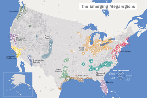 The Great Lakes Megalopolis includes Pittsburgh.
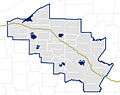 "Cleve-burgh": an emerging metroplex.
See also
- Western Pennsylvania
- Northwest Pennsylvania
- Pennsylvania census statistical areas
- List of Pennsylvania metropolitan areas
External links
| Wikimedia Commons has media related to Pittsburgh metropolitan area. |
References
- ↑ "2010 Census Results Pennsylvania". Retrieved 11 March 2011.
- ↑ "Home - Pittsburgh Post-Gazette". Pittsburgh Post-Gazette.
- ↑ "Explore by Map". Pittsburghtoday.org. Retrieved 2013-07-17.
- ↑ "BEA : BEA Economic Areas (EAs)". Bea.gov. 2004-11-17. Retrieved 2013-07-17.
- ↑ "Pittsburgh Branch Office :: Federal Reserve Bank of Cleveland". Clevelandfed.org. 2008-10-16. Retrieved 2013-07-17.
- 1 2 http://www.whitehouse.gov/sites/default/files/omb/bulletins/2013/b13-01.pdf
- ↑ Green, Elwin (6 December 2009). "Natural gas locked in the Marcellus Shale has companies rushing to cash in on possibilities". Pittsburgh Post-Gazette. Retrieved 28 February 2010.
- 1 2 http://aapa.files.cms-plus.com/PDFs/2011%20U%20S%20%20PORT%20RANKINGS%20BY%20CARGO%20TONNAGE.pdf
- ↑ http://www.census.gov/popest/data/metro/totals/2012/tables/CBSA-EST2012-01.csv
- ↑ http://www.census.gov/popest/data/metro/totals/2012/tables/CBSA-EST2012-02.csv
- ↑
- ↑ "District Map". Lrp.usace.army.mil. Retrieved 2013-07-17.
- ↑ "County Warning Forecast Area WFOs". Nws.noaa.gov. Retrieved 2013-07-17.
- ↑ "United States Military Entrance Processing Command". Mepcom.army.mil. Retrieved 2013-07-17.
- ↑ http://www.census.gov/population/metro/files/lists/historical/50mfips.txt
- ↑ "Rapid 'growth:' Armstrong County added to metro area". Old.post-gazette.com. 2003-06-11. Retrieved 2013-07-17.
- ↑ "Nine southwestern counties form state's first economic district", Observer-Reporter, Washington, PA, August 31, 1967
- ↑ "U.S. FOREIGN-TRADE ZONES". Retrieved 4 November 2013.
- ↑ "RIDC Foreign Trade Zone #33". Retrieved 4 November 2013.
- 1 2 "American FactFinder". United States Census Bureau. Archived from the original on 2013-09-11. Retrieved 2008-01-31.
- ↑ Pittsburgh Pennsylvania Convention and Visitors Bureau. visitpittsburgh.com
- ↑ David Grossman, "Dismantling Pittsburgh: Death of an airline hub," USA Today October 15, 2007
- ↑ http://www.spcregion.org/pdf/servicearea10.pdf
- 1 2 3 4 Briem, Christopher (January 2, 2011). "Welcome to Cleveburgh! Pittsburghers need to rethink their place in the world". Pittsburgh Post-Gazette. Retrieved January 24, 2011.
- ↑ Petrucci, Joe (11 April 2013). "Tracking Dollars Spent, New Map Shows a Divided Pennsylvania". Keystone Edge. Archived from the original on 17 December 2013. Retrieved 31 July 2013.
- 1 2 3 Scarpaci, Joseph L.; Patrick, Kevin Joseph (June 28, 2006). Pittsburgh and the Appalachians: cultural and natural resources in a postindustrial age. University of Pittsburgh Pre. ISBN 978-0-8229-4282-5. Retrieved February 3, 2011.
- 1 2 3 O'Neill, Brian (2009). The Paris of Appalachia: Pittsburgh in the Twenty-first Century. Carnegie Mellon University Press. ISBN 978-0-88748-509-1.
- ↑ Behe, Regis (March 3, 2006). "Steel city an unlikely haven for writers". Pittsburgh Tribune-Review. Retrieved February 7, 2011.
- ↑ "CAVALIERS: The Optimist". National Basketball Association. Retrieved February 7, 2011.
- ↑ Watson, Bruce (December 2, 2010). "America's 11 Best Cities for Telecommuters". DailyFinance. Retrieved February 7, 2011.
- ↑ "Census Regions and Divisions of the United States" (PDF). U.S. Census Bureau. Archived from the original (PDF) on January 20, 2013. Retrieved July 24, 2010.
- ↑ Malady, Matthew J.X. "Where Yinz At: Why Pennsylvania is the most linguistically rich state in the country". Slate.com. Retrieved 1 May 2014.
- ↑ Mostrous, Alexi (September 24, 2009). "Pittsburgh, Site of G-20 Summit, Is Shaking Off Its Smoky Image". The Washington Post. Retrieved February 9, 2011.
- ↑ "Who we are". Great Lakes Metro Chambers Coalition. Retrieved February 9, 2011.
- ↑ "Great Lakes – America 2050". America 2050. Retrieved February 9, 2011.
- ↑ Briem, Christopher (January 2, 2011). "A Turnpike Runs Through It". Null Space. Retrieved February 1, 2011.
- ↑ Briem, Christopher (January 22, 2011). "Residents of Cleveland and Pittsburgh need to rethink their place in the world". The Plain Dealer. Retrieved February 1, 2011.
- ↑ Roman, Joe; Dennis Yablonsky (January 23, 2011). "Tech Belt Initiative helps area compete in global markets:". The Plain Dealer. Retrieved October 17, 2011.
- ↑ "Cleveburgh". Crain's Cleveland Business. April 23, 2007. Retrieved October 17, 2011.
- ↑ Lang, Robert E.; Arthur C. Nelson (January 2007). "The Rise of the Megapolitans" (PDF). Planning: 7–12.
- 1 2 3 Carlisle, Anthony Todd (January 20, 2011). "A newsmaker you should know: He's expanding power of community". Pittsburgh Post-Gazette. Retrieved January 24, 2011.
- ↑ "About P32". Power of 32. Archived from the original on 2010-07-22. Retrieved January 24, 2011.
- ↑ "Get Informed.". Power of 32. Archived from the original on 2010-07-27. Retrieved January 31, 2011.
| Counties | Map of the Pittsburgh Tri-State with green counties in the metropolitan area and yellow counties in the combined area. | |
|---|---|---|
| Major cities | ||
| Cities and towns 15k-50k (in 2010) | ||
| Airports | ||
| Topics | ||
| ||
Harrisburg (capital) | |
| Topics |
|
| Society | |
| Metro areas | |
| Largest cities | |
| Largest municipalities |
|
| Regions |
|
| Counties |
|
Charleston (capital) | |
| Topics |
|
| Society |
|
| Insignia | |
| Regions |
|
| Metro areas | |
| Largest cities | |
| Counties |
|
Columbus (capital) | |
| Topics |
|
| Society | |
| Regions | |
| Metro areas | |
| Largest cities | |
| Counties |
|
Coordinates: 40°25′16″N 79°59′02″W / 40.421°N 79.984°W