Pinnakkanadu
| Pinnakkanadu പിണ്ണാക്കനാട് | |
|---|---|
| village | |
|
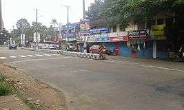
View of Pinnakkanadu from Kanjirappally | |
| Coordinates: 9°36′0″N 76°46′0″E / 9.60000°N 76.76667°ECoordinates: 9°36′0″N 76°46′0″E / 9.60000°N 76.76667°E | |
| Country |
|
| State | Kerala |
| District | Kottayam |
| Government | |
| • Type | Local Body |
| • Body | Thidanadu Panchayath |
| Languages | |
| • Malayalam | Malayalam, English |
| Time zone | IST (UTC+5:30) |
| Telephone code | 4828 |
| Vehicle registration | KL-34 & KL-35 |
| Nearest city | Kanjirappally, Erattupetta, Paika |
| Climate | Tropical monsoon (Köppen) |
| Avg. summer temperature | 35 °C (95 °F) |
| Avg. winter temperature | 18 °C (64 °F) |
| Website |
www |
Pinnakkanadu is a small village located about 40 km East of Kottayam on Kanjirappally-Erattupetta Road, in Kottayam district of Kerala, India. It is 8 km North of Kanjirappally towards Erattupetta, 7 km East of Paika and 15 km West of Mundakkayam.
Administration
The taluk (local government) headquarters is located at Meenachil, village headquarters at Kondoor and the District headquarters at Kottayam.
Taluk : Meenachil Local Body Type: Panchayath Name of Local Body: Thidanadu Village : Kondoor
Economy
Local people mostly work as farmers, cultivating cash crops such as rubber and cocoa, and food crops such as cassava and plantain.
Villages and suburbs
Nearby places include Kalaketty, Mailady, Chettuthodu, Varyanikkadu, Chemmalamattam, Cherani, Manjikkulam ,Njavallil- Nediyapala etc.
Transportation
Nearest Railway stations: Kottayam (40 km), Changanacherry (43 km) or Ettumanoor (30 km)
Nearest Airport is Cochin Airport (Nedumbasserry)- 70 km
Pinnakkanadu can be reached by road from Kanjirappally, Erattupetta or Paika.