Pinhel
| Pinhel | |||
|---|---|---|---|
| Municipality | |||
 | |||
| |||
 | |||
| Coordinates: 40°47′N 7°4′W / 40.783°N 7.067°WCoordinates: 40°47′N 7°4′W / 40.783°N 7.067°W | |||
| Country |
| ||
| Region | Centro | ||
| Subregion | Beira Interior Norte | ||
| Intermunic. comm. | Beiras e Serra da Estrela | ||
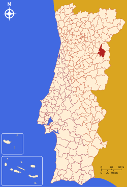
| District | Guarda | ||
| Parishes | 18 | ||
| Government | |||
| • President | Rui Manuel Saraiva Ventura (PSD) | ||
| Area | |||
| • Total | 484.52 km2 (187.07 sq mi) | ||
| Highest elevation | 925 m (3,035 ft) | ||
| Lowest elevation | 150 m (490 ft) | ||
| Population (2011) | |||
| • Total | 9,627 | ||
| • Density | 20/km2 (51/sq mi) | ||
| Time zone | WET/WEST (UTC+0/+1) | ||
| Postal code | 6400 | ||
| Area code | 271 | ||
| Patron | Nossa Senhora do Castelo | ||
| Website | http://www.cm-pinhel.pt | ||

Pinhel (Portuguese pronunciation: [piˈɲɛɫ]) is a municipality in the central subregion of Beira Interior Norte, in Portugal. The municipality population in 2011 was 9,627,[1] in an area of 484.52 km².[2] The urban centre of Pinhel had about 3500 residents in 2001.
History
The origins of this municipality date back to the Calcolithic period, as many of the remnants of ancient cultures from this period remain: namely the rock-art engravings and paintings that line the Côa valley in Cidadelhe. Part of the historic district of Guarda, the region obtained its name for many pine forests that covered the region's hills and mountains.
There are also several references to a pre-Roman or Roman presence, suggesting a continuace occupency since this period.
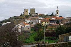
During the medieval period, owing to the defensive requirements of the flegdling nation, several fortified centres developed, including the Pinhel, but also along a line that included: Trancoso, Marialva, Guarda, Castelo Rodrigo, Almeida and Castelo Mendo. The Castle of Pinhel, dates from the reign of King Denis, and the keep tower from his descendent, King Manuel I. Pinhel's strategic position along the frontier with Spain, made the monarchs of Portugal retain many of these fortifications, as well as allowing the development of their territorial claims.
The historical centre, with its narrow roadways, were adapted from the morphology of the terrain, with many patrimonial references to the medieval and modern eras. The homes of the city of Pinhel, some dating from the 16th century, includes some lost references to the presence of a Jewish population at one time, such as along the Rua de Santa Maria. Pinhel was, for a long time, the seat of its own diocese, before being incorporated into the Diocese of Guarda.
The 17th and 18th century were periods of growth for the region, dominated the construction of estates, scattered in many of the historic corners of the municipality, some monumental and decorative.
The urbanized area of Pinhel, the city of Pinhel, was elevated to this status in 1770.
Geography
The municipality of Pinhel is geographuically delimited, in its entirety para two waterways: the Ribeira do Massueime (in the west) and east by the Côa River. It is located in the central part of the district of Guarda and confined by the municipalities of Almeida, Figueira de Castelo Rodrigo, Vila Nova de Foz Côa, Meda, Trancoso and Guarda. The area includes a superficial area of 485 square kilometres (187 sq mi), divided into 18 civil parishes, as well as one urban parish, the city/seat of Pinhel.
The municipality is accessed by a rail-line, the Vila Franca das Naves line for 12 kilometres (7.5 mi), by the A25 roadway (connecting Pinhel and Pínzio, and internationally by its connection to Vilar Formoso, 34 kilometres (21 mi).
The northern part of the municipality is part of the Prehistoric Rock-Art Site of the Côa Valley, an archaeological and geological park known for its inscribed rock formations, created by primitive cultures along the Côa valley. This area, along with Foz Coa has been declared a UNESCO World Heritage site for these primitive engravings.
Pinhel is surrounded by Guarda, Trancoso, Almeida, Figueira de Castelo Rodrigo, Mêda and Vila Nova de Foz Côa, all centres that comprise the district of Guarda.
Administratively, the municipality is divided into 18 civil parishes (freguesias):[3]
- Alto do Palurdo
- Alverca da Beira / Bouça Cova
- Atalaia e Safurdão
- Ervedosa
- Freixedas
- Lamegal
- Lameiras
- Manigoto
- Pala
- Pinhel
- Pínzio
- Souro Pires
- Sul de Pinhel
- Terras de Massueime
- Valbom / Bogalhal
- Vale do Côa
- Vale do Massueime
- Vascoveiro
Architecture
In addition, the following buildings and structures have been classified as national patrimony:
- Castle of Pinhel (Portuguese: Castelo de Pinhel).
See also
References
- ↑ Instituto Nacional de Estatística
- ↑ Direção-Geral do Território
- ↑ Diário da República. "Law nr. 11-A/2013, pages 552 94-95" (pdf) (in Portuguese). Retrieved 29 July 2014.