Pinhal Grande
| Pinhal Grande | ||
|---|---|---|
| Municipality | ||
| ||
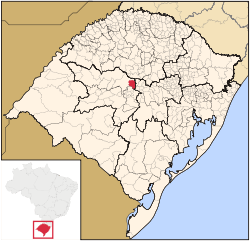 Location in Rio Grande do Sul state | ||
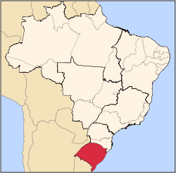
 Pinhal Grande Location in Brazil | ||
| Coordinates: 29°20′46″S 53°18′24″W / 29.34611°S 53.30667°WCoordinates: 29°20′46″S 53°18′24″W / 29.34611°S 53.30667°W | ||
| Country |
| |
| Region | South Region | |
| State | Rio Grande do Sul | |
| Mesoregion | Centro Ocidental Rio-Grandense | |
| Microregion | Santiago | |
| Area | ||
| • Total | 477.13 km2 (184.22 sq mi) | |
| Elevation | 394 m (1,293 ft) | |
| Population (2015) | ||
| • Total | 4,560 | |
| • Density | 9.6/km2 (25/sq mi) | |
| Time zone | BRT/BRST (UTC-3/-2) | |
| Postal code | 98150-xxx | |
| Website |
www | |

Pinhal Grande (Portuguese meaning "large pine forest") is a municipality of the central part of the state of Rio Grande do Sul, Brazil. The population is 4,560 (2015 est.) in an area of 477.13 km².[1] Its elevation is 394 m. It is located 320 km west of the state capital of Porto Alegre, northeast of Alegrete and east of Santo Ângelo. Pinhal Grande is located in the Planalto Médio, one of the pine species found is the Araucaria angustifolia.
Bounding municipalities
History
The first inhabitants of the region were indigenous tribes. The Portuguese dominion explored and later claimed the lands until 1822 when Brazil gained independence. In 1813, the Curitibano João Gonçalves Padilha along with his brother made the agricultural commerde between the region and São Paulo.
The area received immigration and integrated the 4ª Colônia de Imigração Italiana (4th Colony of Italian Immigration), it makes up of people of Italian, Portuguese and Spanish descendents.
The municipality Pinhal Grande was created under Law nº 9600 March 20, 1992.
References
External links
- http://www.citybrazil.com.br/rs/itacurubi/ (Portuguese)