Pillsbury Point State Park
| Pillsbury Point State Park | |
| Iowa State Park | |
| Country | United States |
|---|---|
| State | Iowa |
| County | Dickinson |
| Location | Arnolds Park |
| - elevation | 1,424 ft (434 m) [1] |
| - coordinates | 43°22′01″N 95°08′28″W / 43.36694°N 95.14111°WCoordinates: 43°22′01″N 95°08′28″W / 43.36694°N 95.14111°W |
| Area | 6.48 acres (3 ha) |
| Founded | 1933 |
| Management | Iowa Department of Natural Resources |
 Location of Pillsbury Point State Park in Iowa | |
| Website: none | |
| Area | 1.5 acres (0.61 ha) |
| Built | 1933-1934 |
| Architect |
Central Design Office, Ames National Park Service |
| Architectural style | Rustic |
| MPS | CCC Properties in Iowa State Parks MPS |
| NRHP Reference # | 90001674[2] |
| Added to NRHP | January 12, 1993 |
Pillsbury Point State Park is located in Arnolds Park, Iowa, United States. It is Iowa's smallest state park and unlike the others, it is an urban park.[3] At 6.48 acres (2.62 ha), it is a narrow park that extends along a point of land into West Okoboji Lake adjacent to private summer houses.[4] The overlook at the north end of the park was listed on the National Register of Historic Places in 1990.[2] The historic designation includes walkways along the lake, stone steps, stone benches, and property boundary markers.
History
Pillsbury Point was the location of the Spirit Lake Massacre (1857) in which forty settlers were killed and four women were taken hostage by the Dakota tribe.[3] Graves for several victims, a monument (1895), and the Gardner cabin are adjacent to the park. The Rev. Samuel Pillsbury, for whom the park is named, owned the property in the 1860s. H.H. Lantz developed the property into a recreation area in the 1890s. His widow, Florence B. Lantz, and two other heirs, Miriam L. and John I. Cross, donated the property to the state of Iowa in 1928. Between October 1933 and March 1934 Civilian Conservation Corps (CCC) Company 778 built the walkways along the lake, the two sets of stone steps, and the five stone benches. In 1934 Pillsbury Point was re-designated as a state preserve, which were to protect areas of historic or scientific interest rather than recreational purposes. It was put under the jurisdiction of Gull Point State Park in 1936. In 1940 it was reclassified again as a historic-archaeological park based on the National Park Service's system. By the late 20th century the park became known as an access.
The historic significance of the overlook is derived from its landscape-based approach to park development, which reached its peak during the 1930s.[3] Pillsbury Point was almost entirely landscape development as there are no buildings located here. The stone benches constructed by the CCC are tucked into the slopes along the shore so as not to intrude on the natural setting.[3] Four of the benches are composed of mortared rubble stone backs and seats with a stone base in front of them. The fifth bench is also composed of mortared rubble stone, but is vaguely U-shaped and has no base in front of it. The two sets of steps are likewise mortared rubble stone. The six concrete property boundary markers delineate the property line on the south side of the overlook. There are twelve more markers that mark the parks boundary, but are outside the historic designated area.
References
- ↑ "Pillsbury Point State Park". Geographic Names Information System. United States Geological Survey. 1979-04-30. Retrieved 2016-05-30.
- 1 2 National Park Service (2010-07-09). "National Register Information System". National Register of Historic Places. National Park Service.
- 1 2 3 4 Rebecca Conard. "Pillsbury Point State Park Overlook District" (PDF). National Park Service. Retrieved 2016-05-30. with seven photos from c. 1990
- ↑ Joyce McKay. "Gull Point State Park: Area A" (PDF). National Park Service. Retrieved 2016-05-31.
| Arnolds Park | 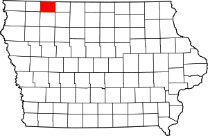 | |
|---|---|---|
| Lake Park | ||
| Milford | ||
| Spirit Lake | ||