Pigeon Forge, Tennessee
| Pigeon Forge, Tennessee | |
|---|---|
| City | |
 | |
| Motto: "The Center of Fun In The Smokies" | |
 Location of Pigeon Forge, Tennessee | |
 U.S. Census Map | |
| Coordinates: 35°47′38″N 83°33′51″W / 35.79389°N 83.56417°WCoordinates: 35°47′38″N 83°33′51″W / 35.79389°N 83.56417°W | |
| Country | United States |
| State | Tennessee |
| County | Sevier |
| Settled | 1780s |
| Incorporated | 1961[1] |
| Named for | 19th-century iron forge along the Little Pigeon River |
| Government | |
| • Mayor | David Wear |
| Area | |
| • Total | 11.6 sq mi (30.0 km2) |
| • Land | 11.6 sq mi (30.0 km2) |
| • Water | 0.0 sq mi (0.0 km2) |
| Elevation | 1,001 ft (305 m) |
| Population (2010) | |
| • Total | 5,875 |
| Time zone | Eastern (EST) (UTC-5) |
| • Summer (DST) | EDT (UTC-4) |
| ZIP code | 37863, 37868 |
| Area code(s) | 865 |
| FIPS code | 47-58080[2] |
| GNIS feature ID | 1297439[3] |
| Website | http://www.cityofpigeonforge.com/ |
Pigeon Forge is a mountain resort city in Sevier County, Tennessee, located in the southeastern United States. As of the 2010 census, the city had a total population of 5,875.
Situated just five miles (8 km) north of the Great Smoky Mountains National Park, Pigeon Forge is a tourist destination that caters primarily to Southern culture and country music fans. The city's attractions include Dollywood, as well as numerous gift shops, outlet malls, amusement rides, and music theaters.
History
Early history

The name "Pigeon Forge" comes from an iron forge built by Isaac Love (1783–1854) sometime around 1820. The name of this forge referred to its location along the Little Pigeon River, in the vicinity of what is now the Old Mill. The name of the river comes from the flocks of passenger pigeons that frequented its banks at the time of the first Euro-American settlers' arrival.[4]
For centuries, the Cherokee used the valley where Pigeon Forge is now located as a hunting ground. A Cherokee footpath known as the "Indian Gap Trail" crossed the Great Smokies from North Carolina, and passed through the Pigeon Forge valley en route to its junction with the Great Indian Warpath in modern Sevierville (US-441 closely parallels this ancient trail, although it crests the mountains at Newfound Gap rather than Indian Gap). From Sevierville, the Warpath headed west toward the Overhill Cherokee towns along the Little Tennessee River.[5]
The Indian Gap Trail brought the first Europeans to the Pigeon Forge area in the early 18th century. Along with hunters and trappers from North Carolina, traders from Virginia had passed through the valley before 1750.[4] Sometime after 1783, Colonel Samuel Wear became one of the first permanent Euro-American settlers in the Pigeon Forge area. Wear, a veteran of the American Revolution, erected a stockade near the confluence of Walden Creek and the Little Pigeon River (what is now Pigeon Forge City Park) in 1792. This "fort" provided a safe stopover for the early pioneers in the Sevier County area. Wear would later serve as a member of the committee that drafted Tennessee's state constitution.[6]
In 1785, the Cherokee signed the Treaty of Dumplin Creek, ceding much of what is now Sevier County to the United States.[7] Among the first to take advantage of this was Robert Shields (1740–1802), who received a survey for a tract of land in the Pigeon Forge area from the Watauga Land Office in 1786. Shields, who like Wear was a veteran of the Revolution, established a small fort along Middle Creek (near what is now Dollywood).[8] Shields' son would later write that the fort was 100 feet (30 m) long and 16 feet (4.9 m) wide, with 12-foot (3.7 m) walls constructed with "heavy logs." The fort contained living quarters for six families, with a common kitchen at one end and a common living room at the other. As his family grew, Shields constructed separate houses for his children, one of which was purchased by Horatio Butler in 1797 and remained with his descendants until being torn down in 1994.[8]
Although the Shields Fort was too far from the main Cherokee trails to ever experience a serious assault, the Wear Fort straddled the Indian Gap Trail, making it a popular target for small bands of Cherokee warriors. After the Cherokee attacked his fort in 1793, a frustrated Wear led a band of 60 frontiersmen across the northwestern Smokies into the Overhill Cherokee region. The frontiersmen attacked and destroyed the town of Tallassee (near modern-day Calderwood Dam), killing at least fifteen Cherokees and capturing several others.[4] In 1794, the Cherokee fired on Wear and his two sons just outside Calvin's Blockhouse (near Maryville), although the Wears escaped unharmed.[9]
While treaties negotiated at the Tellico Blockhouse in 1794 and 1798 brought calm to the region, sporadic fighting between Cherokees and the settlers continued. One notable incident occurred in 1802, Tavenor Runyan (1787-1802), the son of Isaac Barefoot Runyan (1749–1845) and Margaret Rambo[10] (who had settled near the heart of modern Pigeon Forge), was killed by a Cherokee warrior. The recently elected Governor Archibald Roane was forced to personally intervene to prevent retaliatory strikes.
19th century

Like many Appalachian communities, religion played a major role in the early history of Pigeon Forge. In the early 19th century, circuit riders were preaching in the valley, creating a large Methodist following that remains to the present day. On October 20, 1808, Bishop Francis Asbury delivered a sermon at what is now Shiloh Memorial Cemetery in the northern half of Pigeon Forge, where a crude log church had been erected.[11] Among the first "tourists" to visit Pigeon Forge came for the extended revivals that were held in the Middle Creek area (on the grounds of what is now Middle Creek Methodist Church) as early as 1822. These revivals could last for weeks at a time.[12]
In 1810, Revolutionary War veteran Mordecai Lewis obtained a 151-acre (61 ha) land grant along the Little Pigeon River near the heart of what is now Pigeon Forge. In 1817, Lewis's son-in-law, Isaac Love (1783−1854), established the iron forge for which the city was eventually named. The complex included a bloomery furnace and water-powered trip hammer to smelt and mold ore into iron bars. Love erected the Pigeon Forge Mill in 1830, and on May 29, 1841, Love's son William established a post office—which he named "Pigeon Forge"—for the mill and the small community that had developed in its vicinity. Local businessman John Sevier Trotter (1807−1884) purchased the mill and furnace in 1849, and subsequently made numerous modifications, including the addition of a sawmill.[13] While the iron furnace was sold and relocated in the 1880s, the Pigeon Forge Mill— usually called the "Old Mill"— still stands, and has been placed on the National Register of Historic Places.
In the 1870s, a health resort was established in Pigeon Forge at Henderson Springs, adjacent to the Wear's Fort site on the town's north side.[14] It was common during this period for the residents of large urban areas to visit mountain springs, the waters of which were thought to have health-restoring qualities.
Commercial boom
In the early 20th century, Pigeon Forge was an isolated mountain hamlet with no major roads. The nearest railroad station was in Sevierville. Bridges were also rare, the only major water crossings being a string of fords along the Little Pigeon.[15][16]
When the Great Smoky Mountains National Park was opened in 1934, the Tennessee Valley Authority reported that there were no tourism-oriented businesses in Pigeon Forge. By the 1950s, improvements to US-441 led to the establishment of a few campgrounds and lodges, but little that would generate major revenue. During this period, however, two factors in nearby Gatlinburg would lead to the commercial boom Pigeon Forge would experience in the latter half of the 20th century. First, Gatlinburg, itself surrounded by high mountain ridges, had limited land resources.[14] Second, the land resources it did have were largely controlled by a few local families who thwarted attempts by outside businesses to take advantage of the town's prime location. Thus, outside entrepreneurs were forced to look elsewhere. Pigeon Forge, being just north of Gatlinburg along US-441, was the obvious target.
In 1961, shortly after Pigeon Forge officially incorporated, North Carolina brothers Grover and Harry Robbins opened Rebel Railroad in the town's Middle Creek area. The railroad simulated a ride on a Confederate steam train that was under attack by Union soldiers during the Civil War, playing upon the centennial of the war that was sweeping the country at the time. After the Union assault was beaten back, the railroad came to a stop at a mock-frontier mountain town, complete with blacksmith shop, general store, and saloon. By 1964, the Civil War Centennial was beginning to die down, so the Robbins brothers decided to rename Rebel Railroad Goldrush Junction. The attraction was reworked with a "Wild West" theme replacing the Civil War theme, in similar fashion to the Robbins' other tourist train ride in North Carolina, Tweetsie Railroad. Goldrush Junction was much more successful than Rebel Railroad had ever been, prompting the Robbins to buy a log flume amusement ride and erect it on the property in 1967.[17] According to a park tourist brochure of the time, the ride was "brought to Goldrush Junction from the New York World's Fair, where it was one of the most successful attractions."[18]
In 1969, after Pigeon Forge issued a zoning plan assigning the entire strip along US-441 for tourism use, Art Modell (owner of the Cleveland Browns) purchased Goldrush Junction. In 1976, Modell sold the Junction to the Herschend Brothers of Branson, Missouri. The Herschends renamed the park Silver Dollar City after their successful theme park in Branson.[19] The Ozark mountain theme of the Branson location was easily reapplied as an Appalachian theme in Pigeon Forge, and the park's attendance began to climb.
In 1982, hoping the capitalize on the publicity generated by the Knoxville World's Fair, Pigeon Forge initiated an aggressive economic plan that centered around theme parks, outlet malls, and live music venues. The first outlet mall, Factory Merchants, opened that same year. By 1987, there were four outlet malls in Pigeon Forge, and by the early 1990s, outlet malls provided 44% of the town's gross revenue.[20]
The increasing number of tourist attractions brought competition for Silver Dollar City and its chief competitor in Pigeon Forge, Magic World, which had constructed a theme park on the slopes of Pine Mountain in the city's south section. In 1985, the Herschends approached entertainer Dolly Parton (who was born in nearby Sevierville) with a proposal for a partnership in the promotion and operation of Silver Dollar City. After lengthy negotiations, Parton became a minority partner in the enterprise, and Silver Dollar City was renamed Dollywood to kick off a major marketing campaign. The move proved successful as Dollywood continued expansion into the 21st century.[19] Magic World folded in 1994.
While the commercial boom in Pigeon Forge vastly increased the town's revenue, it had several undesirable effects. As land value skyrocketed, many farmers could no longer afford the accompanying high property taxes and were forced to sell their land. The high cost of living in Pigeon Forge is difficult to offset with the low wage jobs that often accompany the tourist industry.[21]
 The "Dollywood Express" at Dollywood
 An outlet mall in Pigeon Forge.
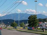 Pigeon Forge with Mount Le Conte in the background.
Geography and climate
Pigeon Forge is located at 35°47′38″N 83°33′51″W / 35.79389°N 83.56417°W (35.793946, −83.564124)[22] on the West Prong of the Little Pigeon River.
According to the United States Census Bureau, the city has a total area of 11.6 square miles (30.0 km²), all land.
The West Fork of the Little Pigeon River flows north from its source high on the slopes of Mount Collins through Sevier County before linking up with the Middle Fork in Sevierville. Pigeon Forge occupies a narrow valley along this river between Sevierville and Gatlinburg. High ridges surround Pigeon Forge on three sides, with Pine Mountain to the west, Shields Mountain to the east, and Cove Mountain to the south. A bend in the Little Pigeon provides the city's northern border with Sevierville, and a narrow gorge cut by the river between Cove Mountain and Shields Mountain acts as the city's buffer with Gatlinburg.
U.S. Route 441, known as "The Parkway", runs through the middle of Pigeon Forge en route to Gatlinburg and the Great Smoky Mountains National Park, where it crests at Newfound Gap before descending to Cherokee, North Carolina. The 6-lane strip along 441 contains most of Pigeon Forge's tourist attractions. U.S. Route 321 (known as Wears Valley Road in Pigeon Forge) connects the town with Wears Valley and Townsend to the west. Teaster Lane runs along the eastern side of the city and serves as a local 4-lane road bypassing some of the Parkway and is relatively undeveloped (minus a few shopping centers). TN 449 serves as a bypass to both Sevierville and most of Pigeon Forge, plus directly connects with Dollywood. It runs north from the Parkway (at traffic light #8) as Dollywood Lane and changes names to Veterans Blvd at Teaster Lane. Besides the entrance to Dollywood, TN 449 traverses undeveloped land due to the fact the highway was built recently. Upper Middle Creek Road (a section of which is also called Dollywood Lane) connects to the rural areas of eastern Sevier County.
| Climate data for Pigeon Forge, Tennessee | |||||||||||||
|---|---|---|---|---|---|---|---|---|---|---|---|---|---|
| Month | Jan | Feb | Mar | Apr | May | Jun | Jul | Aug | Sep | Oct | Nov | Dec | Year |
| Record high °F (°C) | 81 (27) |
85 (29) |
86 (30) |
92 (33) |
98 (37) |
106 (41) |
105 (41) |
100 (38) |
101 (38) |
94 (34) |
85 (29) |
80 (27) |
106 (41) |
| Average high °F (°C) | 48 (9) |
53 (12) |
61 (16) |
70 (21) |
77 (25) |
83 (28) |
86 (30) |
85 (29) |
80 (27) |
71 (22) |
61 (16) |
51 (11) |
68.8 (20.5) |
| Average low °F (°C) | 25 (−4) |
28 (−2) |
33 (1) |
41 (5) |
50 (10) |
58 (14) |
63 (17) |
61 (16) |
55 (13) |
43 (6) |
34 (1) |
28 (−2) |
43.3 (6.3) |
| Record low °F (°C) | −18 (−28) |
−13 (−25) |
−6 (−21) |
19 (−7) |
26 (−3) |
33 (1) |
43 (6) |
40 (4) |
27 (−3) |
15 (−9) |
2 (−17) |
−12 (−24) |
−18 (−28) |
| Average precipitation inches (mm) | 4.56 (115.8) |
4.66 (118.4) |
4.74 (120.4) |
4.22 (107.2) |
5.88 (149.4) |
5.52 (140.2) |
5.82 (147.8) |
4.57 (116.1) |
4.35 (110.5) |
2.67 (67.8) |
4.13 (104.9) |
4.32 (109.7) |
55.44 (1,408.2) |
| Source: [23] | |||||||||||||
Demographics
| Historical population | |||
|---|---|---|---|
| Census | Pop. | %± | |
| 1970 | 1,361 | — | |
| 1980 | 1,822 | 33.9% | |
| 1990 | 3,027 | 66.1% | |
| 2000 | 5,083 | 67.9% | |
| 2010 | 5,875 | 15.6% | |
| Est. 2015 | 6,171 | [24] | 5.0% |
| Sources:[25][26] | |||
As of the census[2] of 2000, there were 5,083 people, 2,021 households, and 1,402 families residing in the city. The population density was 438.8 people per square mile (169.5/km²). There were 2,799 housing units at an average density of 241.6 per square mile (93.3/km²). The racial makeup of the city was 94.71% White, 0.65% African American, 0.22% Native American, 1.28% Asian, 0.06% Pacific Islander, 1.93% from other races, and 1.16% from two or more races. Hispanic or Latino of any race were 3.70% of the population.
There were 2,021 households out of which 28.9% had children under the age of 18 living with them, 51.8% were married couples living together, 13.2% had a female householder with no husband present, and 30.6% were non-families. 24.2% of all households were made up of individuals and 8.9% had someone living alone who was 65 years of age or older. The average household size was 2.45 and the average family size was 2.89.
In the city the population was spread out with 22.5% under the age of 18, 9.4% from 18 to 24, 28.5% from 25 to 44, 24.1% from 45 to 64, and 15.6% who were 65 years of age or older. The median age was 38 years. For every 100 females there were 91.6 males. For every 100 females age 18 and over, there were 87.3 males.
The median income for a household in the city was $30,746, and the median income for a family was $34,505. Males had a median income of $26,397 versus $21,370 for females. The per capita income for the city was $16,621. About 10.0% of families and 13.4% of the population were below the poverty line, including 15.2% of those under age 18 and 6.7% of those age 65 or over.
Attractions and events

Perhaps the most famous attractions in Pigeon Forge are the Dollywood theme park and the Dixie Stampede theater, both owned by country music superstar Dolly Parton—whose hometown is in Sevierville, just a few miles from Pigeon Forge. Other theaters and attractions include the Titanic Museum, the Southern Gospel Museum and Hall of Fame, the Country Tonite Theater, the Lumberjack Feud, the Comedy Barn, WonderWorks children's museum, Biblical Times Dinner Theater, Smoky Mountain Opry, the Memories Theatre, Flyaway Indoor Skydiving, NASCAR Speedpark, Smoky Mountain Alpine Coaster, Jurassic Jungle Boat Ride, Hollywood Wax Museum Pigeon Forge, The Island in Pigeon Forge (featuring the Great Smoky Mountain Wheel Tribute to Frank Sinatra & The Rat Pack and The Island Show Fountains), and seasonal events such as Winterfest. These attractions and the natural beauty of the area draw approximately 11 million visitors each year.
Car and truck shows
Pigeon Forge has become the southeast mecca for car and truck enthusiasts. The calendar of car and truck show events runs from April through September and has included the following:
- Spring Rod Run
- Chevy/GMC Truck Nationals
- Hooter's GMC/Chevy Truckin' Nationals
- Annual Smoky Mountain Classic Chevy Roundup
- Great Smoky Mountain Truck Show
- Silver Dollar Open Rod Run
- Pontiac Car Club Show
- Camaro, Chevelle, Nova Nationals
- Cobra Mustang Club
- Shades of the Past Rod Run Show
- Fall Rod Run
- Smoky Mountain Model-A Car Rally
- Annual Pigeon Forge Starion/Conquest Meet
- Ford F-100 Super Nationals
- Annual Patriot Festival[27]
Government
Pigeon Forge has a Manager-Commission form of Government.
Elected officials
This is a list of elected officials as of April 2014:
- Earlene Teaster – City Manager
- Eric Brackins – Assistant City Manager
- David Wear – City Commissioner and Mayor
- Kevin McClure – City Commissioner and Vice-Mayor
- Joyce Brackins – City Commissioner
- Jay Ogle – City Commissioner
- Ken Maples – City Commissioner
- Jack H. Baldwin – Police Chief
- Tony L. Watson – Fire Chief
Public services

Pigeon Forge Public Services employs over 300 people.[28] The city government has 100 miles (160 km) of water piping, 430 fire hydrants, 8 water tanks and 4 pump stations,[29] 84 miles (135 km) of publicly maintained streets and roads,[30] 65 miles (105 km) of sanitary sewers,[31] and 182 automobiles.[32]
The current mayor is David Wear.[33]
Mass transit
Pigeon Forge is served by a mass transit system of buses. The buses are referred to as "Fun Time Trolleys" due to their aesthetic resemblance to early-20th-century trolleys. There are over 100 trolley stops.[34]
Water plant
The water plant in Pigeon Forge can treat 12,000,000 U.S. gallons (10,000,000 imp gal; 45,000,000 L) of water per day. The city storage system holds 6,650,000 U.S. gallons (5,540,000 imp gal; 25,200,000 L) of water. The city supplies Gatlinburg with 1,000,000 U.S. gallons (830,000 imp gal; 3,800,000 L) of water per day.[31]
Parks and recreation
Pigeon Forge Parks and Recreation Department has three parks and 2 miles (3200 m) of Greenways.
- Pigeon Forge City Park is an 18-acre (73,000 m2) park. It consists of:[35]
- 1.25 miles (2 km) walking trail
- 5 lighted softball/baseball fields
- 2 asphalt basketball courts
- 6 lighted tennis courts
- 1 lighted volleyball court
- 1 horseshoe pit
- 2 lighted pavilions
- 2 unlighted playgrounds
- 2 concession stands
- 1 outdoor swimming pool
- Patriot Park is a 16 acres (65,000 m2) park. It consists of:[35]
- 1 lighted pavilion
- 1/2 mile (800 m) lighted walking trail
- 16 picnic tables
- 1 lighted Gazebo
- 29 park benches
- Wear Farm City Park consists of:
- Five 300’ lighted softball/baseball fields
- One lighted football field
- One multi-purpose field
- Two playgrounds
- Three shelters
- Walking trails
- Basketball court
- Two concession stand/restroom buildings
- Maintenance support facility
- Irrigation throughout the park
- Ample parking
Alcoholic beverages
Unlike neighboring Gatlinburg and Sevierville, Pigeon Forge had remained a dry jurisdiction of the state (Tennessee is dry by default), with a few select premises opting to sell low-alcohol beers and some wines. Certain sections of Pigeon Forge, including religious leaders, oppose legalized liquor, warning of the social consequences that may follow, while others argue that the city is losing tax dollars to neighboring cities.
Referendums to permit liquor by the drink inside the city limits failed in 2009 and 2011. Liquor by the drink appeared to have won by a 100-vote margin in a contentious 2012 referendum in which the number of ballots cast exceeded the number of eligible voters by more than 300.[36] In court depositions taken in connection with a lawsuit to overturn the election, one registrar testified that her instructions were to allow everyone listed on her roster to vote on the referendum regardless of whether they lived inside the city limits.[37] Poll worker Sarah Ownby said in her deposition she was "100 percent sure" ballots were cast by people not entitled to vote on the issue.[36] Ownby also testified some voters who were eligible to vote in the referendum were not allowed to do so.[38]
On January 10, 2013, Sevier County Chancellor Telford Forgety ruled that the 2012 liquor by the drink referendum would be scrapped due to its questionable results. The chancellor ordered that a new vote be held within 45 to 60 days.[39]
On March 13, 2013, liquor by the drink passed in Pigeon Forge by a vote of 952 to 798.[40]
References
- ↑ Tennessee Blue Book, 2005-2006, pp. 618-625.
- 1 2 "American FactFinder". United States Census Bureau. Retrieved 2008-01-31.
- ↑ "US Board on Geographic Names". United States Geological Survey. 2007-10-25. Retrieved 2008-01-31.
- 1 2 3 J.A. Sharp, "The Historic Beginnings of Pigeon Forge" The Sevier County Library History Center Website. Retrieved: 15 September 2007. Archived May 15, 2003, at the Wayback Machine.
- ↑ Michal Strutin, History Hikes of the Smokies (Gatlinburg: Great Smoky Mountains Association, 2003), 322-323.
- ↑ J.G.M. Ramsey, Annals of Tennessee (Johnson City, Tennessee: Overmountain Press, 1999), 652.
- ↑ Goodspeed Publishing Company, "The History of Sevier County," The History of Tennessee, 1887. Retrieved: 15 September 2007.
- 1 2 Beulah Linn, "The Horatio Butler House," Smoky Mountain Historical Society Newsletter 20, no. 1 (Spring 1994): 13.
- ↑ J.G.M. Ramsey, Annals of Tennessee (Johnson City, Tennessee: Overmountain Press, 1999), 591.
- ↑ Descendants of Isaac Barefoot Runyan by Marie Runyan Wright, Gallway Press 1980
- ↑ Information obtained from Shiloh Memorial Cemetery Association plaque at Shiloh Memorial Cemetery in Pigeon Forge, Tennessee.
- ↑ Beulah Linn, "The Isaac Trotter Papers," Smoky Mountain Historical Society Newsletter 12, no. 2 (Summer 1986): 33.
- ↑ Robbie Jones, The Historic Architecture of Sevier County, Tennessee (Sevierville, Tenn.: Smoky Mountain Historical Society, 1997), pp. 24-25, 30, 44.
- 1 2 C. Brenden Martin, "Pigeon Forge, Tennessee," Encyclopedia of Appalachia (Knoxville: University of Tennessee Press, 2006), 667.
- ↑ Beulah Linn, "The West Fork of the Little Pigeon River," Smoky Mountain Historical Society Journal 22, no. 2 (Summer 1996): 3.
- ↑ Pearl Cashell Jackson, pi beta phi settlement school (University of Texas, 1927), 14.
- ↑ Hollis, Tim. "Tweetsie and Dolly rush for the Gold." The Land of the Smokies: Great Mountain Memories. 1st ed. Jackson, MS: The University Press of Mississippi, 2007. 124–129.
- ↑ Goldrush Junction tourist brochure.
- 1 2 C. Brenden Martin and Camille Wells, "Dollywood," Encyclopedia of Appalachia (Knoxville: University of Tennessee Press, 2006), 639.
- ↑ Margaret Foraker, "Economic Dependency and Tourism", Encyclopedia of Appalachia (Knoxville: University of Tennessee Press, 2006), 640.
- ↑ Margaret Foraker, "Economic Dependency and Tourism," Encyclopedia of Appalachia (Knoxville: University of Tennessee Press, 2006), 640.
- ↑ "US Gazetteer files: 2010, 2000, and 1990". United States Census Bureau. 2011-02-12. Retrieved 2011-04-23.
- ↑ "Monthly Averages for Pigeon Forge, TN (37863)". The Weather Channel. Retrieved May 20, 2012.
- ↑ "Annual Estimates of the Resident Population for Incorporated Places: April 1, 2010 to July 1, 2015". Retrieved July 2, 2016.
- ↑ "Census of Population and Housing: Decennial Censuses". United States Census Bureau. Retrieved 2012-03-04.
- ↑ "Incorporated Places and Minor Civil Divisions Datasets: Subcounty Resident Population Estimates: April 1, 2010 to July 1, 2012". Population Estimates. U.S. Census Bureau. Retrieved 11 December 2013.
- ↑ http://www.mypigeonforge.com/events/patriot-festival/
- ↑ Pigeon Forge, TN
- ↑ Pigeon Forge, TN
- ↑ Pigeon Forge, TN
- 1 2 Pigeon Forge, TN
- ↑ Pigeon Forge, TN
- ↑ Pigeon Forge, TN
- ↑ :: Pigeon Forge / Sevierville Fun Time trolley ::
- 1 2 Webpage.pub
- 1 2 "Poll worker describes confusion during Pigeon Forge liquor vote". The Knoxville News-Sentinel.
- ↑ "Pigeon Forge Liquor Vote". WJHL-TV.
- ↑ "New election only cure for Pigeon Forge vote hangover". The Knoxville News-Sentinel.
- ↑ Balloch, Jim. (January 10, 2013). "Judge rules Pigeon Forge liquor vote must be scrapped, orders new election". The Knoxville News-Sentinel: retrieved 1/11/2013.
- ↑ WATE.com https://web.archive.org/web/20130605052932/http://www.wate.com/story/21638469/pigeon-forge-voters-consider-liquor-by-the-drink-question-again. Archived from the original on 22 June 2016. Retrieved 14 March 2013. Missing or empty
|title=(help)
External links
| Wikivoyage has a travel guide for Pigeon Forge. |
Municipalities and communities of Sevier County, Tennessee, United States | ||
|---|---|---|
| Cities | ||
| Town | ||
| CDPs | ||
| CCDs | ||
| Unincorporated communities | ||
| Footnotes | ‡This populated place also has portions in an adjacent county or counties | |