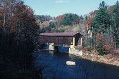
Pier Bridge
|
Pier Bridge | |
 | |
  | |
| Nearest city | Newport, New Hampshire |
|---|---|
| Coordinates | 43°21′43″N 72°14′31″W / 43.36194°N 72.24194°WCoordinates: 43°21′43″N 72°14′31″W / 43.36194°N 72.24194°W |
| Area | 1 acre (0.40 ha) |
| Built | 1907 |
| Architectural style | Town lattice truss |
| NRHP Reference # | 75000134[1] |
| Added to NRHP | June 10, 1975 |
The Pier Bridge is a historic covered bridge in Newport, New Hampshire. Originally built in 1907 to carry the Boston and Maine Railroad across the Sugar River, it now carries the multi-use Sugar River Trail, which was built on the abandoned right-of-way. It is located about 0.5 miles (0.80 km) east of the Chandler in western Newport. It consists of two Town-Pratt lattice trusses, resting on granite abutments which have been capped by concrete, and a central pier of similar construction. The western span is 106 feet (32 m) long, the eastern one 121 feet (37 m). The bridge is named for the fact that it has a central pier.[2]
The bridge was listed on the National Register of Historic Places in 1975.[1]
See also
- National Register of Historic Places listings in Sullivan County, New Hampshire
- List of bridges on the National Register of Historic Places in New Hampshire
- List of New Hampshire covered bridges
References
- 1 2 National Park Service (2010-07-09). "National Register Information System". National Register of Historic Places. National Park Service.
- ↑ "NRHP nomination for Pier Bridge" (PDF). National Park Service. Retrieved 2014-07-14.
| Topics | 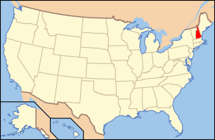 | |
|---|---|---|
| Lists by county | ||
| Other lists | ||
| ||
This article is issued from Wikipedia - version of the 11/30/2016. The text is available under the Creative Commons Attribution/Share Alike but additional terms may apply for the media files.