Pico do Fogo
| Pico do Fogo | |
|---|---|
 | |
| Highest point | |
| Elevation | 2,829 m (9,281 ft) [1] |
| Prominence |
2,829 m (9,281 ft) Ranked 120th |
| Isolation | 1,674 kilometres (1,040 mi) |
| Listing |
Country high point Ultra List of mountains in Cape Verde |
| Coordinates | 14°57′00″N 24°20′30″W / 14.95000°N 24.34167°WCoordinates: 14°57′00″N 24°20′30″W / 14.95000°N 24.34167°W [1] |
| Geography | |
 Pico do Fogo | |
| Geology | |
| Mountain type | Somma volcano |
| Last eruption | November 2014 to February 2015 |
Pico do Fogo pronounced: [ˈpiku du ˈfoɡu] is the highest peak of Cape Verde, rising to 2,829 metres (9,281 ft) above sea level. It is an active stratovolcano lying on the island of Fogo. The main cone last erupted in 1675, causing mass emigration from the island. A subsidiary vent erupted in 1995. The only deadly eruption was in 1847 when earthquakes killed several people.
Fogo is a hotspot volcanic island. Its most recent eruptions have occurred in 1951, 1995 and 2014. It is the youngest and most active volcano in the Cape Verde Islands, a short chain of volcanic islands that generally are younger at the western end, formed as the African Plate moved towards the east over the hotspot.[2]
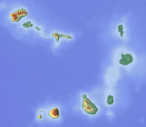
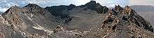
Fogo consists of a single volcano, so the island is nearly round and about 25 kilometers (16 mi) in diameter. The large summit caldera (about 10 kilometers in the north-south direction and 7 kilometers in the east-west direction) is not located in the center of the island, but rather towards its northeastern corner. The caldera is bounded by steep near-vertical fault scarps on the north, west, and south sides but is breached to the east where lava can flow to the coast. North-northeast-trending eruptive fissures opened along the western flank of Pico, which formed inside the caldera between about 1500 and 1760.[2] The current topography of Fogo, with the caldera open to the sea on the east side, results from the sliding of the east flank of the volcano towards the ocean.[2]
The mountain's slopes are used to grow coffee, while its lava is used as building material. Near its peak is a caldera and a small village, Chã das Caldeiras, is inside this caldera.
1995 eruption
The 1995 eruption began on the night of 2–3 April, covering the island with a cloud of ash.[2] Residents were evacuated from Chã das Caldeiras, as their homes were destroyed.[3]

Residents reported that the eruption was preceded by small earthquakes which began about six days prior to the first eruption of lava. These earthquakes increased in magnitude and frequency through April 2, and a particularly strong one was reported at about 8 p.m., four hours before the eruption apparently began. Just after midnight, fissures opened on the flank of Pico. One resident said it looked as if the cone had "been cut by a knife." The eruption began with Strombolian activity, quickly followed by a 'curtain-of-fire' lava fountain that fed a flow which cut off the road to the village of Portela by 2 a.m. The 1,300 people living inside the caldera fled during the night to the safety of villages on the north coast. No one was killed, but about 20 people required medical attention.[2]
During the day on April 3, the island was engulfed by a thick cloud of dark ash that reached 2.5 to 5 kilometers high. The initial flows were pahoehoe lava, although their extent was apparently small. The violent eruption produced lava bombs up to 4 meters across that were ejected as far as 500 meters from the vents. On April 4, lava fountains reached 400 meters high beneath a cloud of ash about 2 kilometers high. A new scoria cone formed that was open to the southwest and fed a growing lava flow. On April 5, the new lava flow reached the western caldera wall and destroyed about five houses and the main water reservoir. During these first few days, civil authorities evacuated about 3,000 people.[2]

The eruption became steadier after the first few days, and moderate, Hawaiian-style lava fountains about 100–120 meters high built a spatter cone more than 140 meters high. The flows were lava, and flowed towards the west to the caldera wall, then turned north. These flows advanced episodically as pressure built from ponding and thickening of the flows. On April 13, a second lava flow began to cover an earlier, stagnant lava flow, and was almost entirely on top of the earlier flow until April 15, when it spread out and destroyed another home. Cinder fell as far as two kilometers south of the vents on April 15. By the 17th, the flow had advanced to within 420 meters of the nearest house in the village of Portela.[2]
On April 18, a portable seismometer began to record much stronger volcanic tremors that indicated a change in eruptive style from lava fountains back to Strombolian activity. Spatter was discharged every 3–8 seconds with loud gas bursts. In addition, the eruptive rate increased and the upper 300 meters of the channel was largely pahoehoe lava. The eruption rates, estimated from the dimensions and flow rates in the channel, were between 4 and 8.5 million cubic meters per day.[2]
During the night of April 18, a series of large, explosive bursts occurred that may have followed collapse of parts of the cone into the vents and subsequent explosive clearing of the debris. By morning, the activity had returned to lava fountaining, and the seismic record was much quieter. The lava flows continued to thicken, and lava ponded along the central channel.[2]
2014 eruption
The Fogo volcano returned to activity in 2014, having started erupting shortly after 10 a.m. of Sunday, 23 November 2014.[4] There had been a few days of heightened seismic activity,[4] but they worsened beginning at 8 p.m. on Saturday night.[5]
The population of Chã das Caldeiras, totaling around 1,000 inhabitants, spent the night outside their homes due to the strong earthquakes,[4] and started being evacuated when the eruption began.[5] As in 1995, some people initially refused to abandon their homes, but eventually heeded the authorities' instructions.[5]
Bruno Faria, a Cape Verdean vulcanologist, said the intensity of the eruption surpassed that of the 1995 eruption, and approached that of the 1951 eruption, one of the strongest ever recorded on the island.[5] The eruption gained in intensity after 23 November 2014.The village of Portela in the Chã das Caldeiras is now covered by a lava stream which has completely destroyed the housing stock.[6]
After 77 days of activity, the eruption stopped on 8 February 2015.[7]
In the international media
The 2014 eruption of the Pico do Fogo received limited attention in the international media. The geographer Christophe Neff wrote in a blog post about this fact. In this post – “L’éruption du Pico do Fogo du 23.11.2014 – l’éruption oublié …. (The eruption of the Pico do Fogo – the forgotten eruption)”.[6] Neff writes that except for the Lusophone world, and some limited attention in the Francophone world (Cabo Verde is member of the Organisation internationale de la Francophonie), the eruption received little attention in the international media.
Neff gave the example of Germany, where the first article in the German media, an article in Der Spiegel-online[8] – was published only on 9 December 2014, over two weeks after the start of the eruption.[6]
The British geologist David Rothery also posted a blog article "Why have we heard so little about the devastating Cape Verde volcano?"[9] with a similar content. At the end of the article, Rothery placed a provocative question "Or do we care about volcanoes only if there’s a chance of them inconveniencing our air-travel plans?"[9]
73,000 years ago
The eastern side of Fogo collapsed into the ocean 73,000 years ago, creating a tsunami 170 meters high which struck the island of Santiago in the Cape Verde islands.[10]
References
- 1 2 "Fogo". Global Volcanism Program. Smithsonian Institution. Retrieved 2011-04-11.
- 1 2 3 4 5 6 7 8 9 "Volcano Watch: Fogo Volcano, Cape Verde Islands". Hawaiian Volcano Observatory. April 21, 1995. Retrieved 2007-10-17.
- ↑ "Fogo Caldera". MTU Volcanoes Page. Michigan Technological University. Retrieved 2007-10-17.
- 1 2 3 "Volcano of Fogo in eruption". Oceanpress.info. 23 November 2014.
- 1 2 3 4 Susana Salvador (23 November 2014). "Vulcão do Fogo está em erupção e obriga a evacuar Chã das Caldeiras" (in Portuguese). Diário de Notícias.
- 1 2 3 Christophe Neff (10 December 2014). "L'éruption du Pico do Fogo du 23.11.2014 – l'éruption oublie …." (in French). Blogs le Monde on LeMonde.fr.
- ↑ Christophe Neff (28 April 2015). "retour sur le vieil homme – le Pico do Fogo" (in French). Blogs le Monde on LeMonde.fr.
- ↑ Axel Bojanowski (9 December 2014). "Kapverdische Inseln: Lavamassen löschen Dörfer aus" (in German). Spiegel-online Wissenschaft.
- 1 2 David Rothery (10 December 2014). "Why have we heard so little about the devastating Cape Verde volcano?". the Conversation.
- ↑ "Island boulders reveal ancient mega-tsunami". Retrieved 2015-10-06.
External links
| Wikimedia Commons has media related to Pico de Fogo. |
- Fogo, Cape Verde Islands at NASA Earth Observatory
- Fogo Summary at Smithsonian Global Volcanism Program