Pico Bonpland
| Pico Bonpland | |
|---|---|
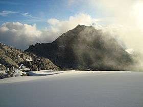 Pico Bonpland as seen from the Pico Humboldt | |
| Highest point | |
| Elevation | 4,883 m (16,020 ft) |
| Coordinates | 8°32′N 71°00′W / 8.533°N 71.000°WCoordinates: 8°32′N 71°00′W / 8.533°N 71.000°W |
| Geography | |
| Location | Mérida, Venezuela |
| Parent range | Sierra Nevada, Andes |
| Climbing | |
| First ascent | 1911 by Alfredo Jahn (was the same ascent to the Pico Humboldt as well) |
| Easiest route | By the excursionist route Pico Espejo-Mucuy. |
Pico Bonpland is Venezuela's third highest peak, at 4,883 metres above sea level. It is located in the Sierra Nevada de Merida, in the Venezuelan Andes of (Mérida State). The peak with its sister peak Pico Humboldt, and the surrounding páramos are protected by the Sierra Nevada National Park. The name of the peak is in honor to Aimé Bonpland, although he never visited the Venezuelan Andes.
The glaciers located in the Bonpland were the result from Merida glaciation in the Pleistocene. By 2011 they had all disappeared.
References
- Jahn A, Observaciones glaciológicas de los Andes venezolanos. Cult. Venez. 1925, 64:265-80
This article is issued from Wikipedia - version of the 5/8/2016. The text is available under the Creative Commons Attribution/Share Alike but additional terms may apply for the media files.