Pialligo, Australian Capital Territory
| Pialligo Canberra, Australian Capital Territory | |||||||||||||
|---|---|---|---|---|---|---|---|---|---|---|---|---|---|
 | |||||||||||||
| Coordinates | 35°18′23″S 149°10′48″E / 35.30639°S 149.18000°ECoordinates: 35°18′23″S 149°10′48″E / 35.30639°S 149.18000°E | ||||||||||||
| Population | 249 (2011 census)[1] | ||||||||||||
| • Density | 51.13/km2 (132.4/sq mi) | ||||||||||||
| Established | 1928 | ||||||||||||
| Gazetted | 20 September 1928 | ||||||||||||
| Postcode(s) | 2609 | ||||||||||||
| Area | 4.87 km2 (1.9 sq mi) | ||||||||||||
| District | Majura | ||||||||||||
| Territory electorate(s) | Kurrajong | ||||||||||||
| Federal Division(s) | Canberra | ||||||||||||
| |||||||||||||
Pialligo (postcode: 2609) is a rural suburb of Canberra, Australian Capital Territory, Australia. The name Pialligo has been used for the area since at least 1820, and is probably of Aboriginal origin. It was also the name for the parish in the area. Streets in Pialligo are named with Aboriginal words.[2]
Beltana Road in Pialligo is home to many of Canberra's nurseries. Canberra Airport is located adjacent to Pialligo across Pialligo Avenue.
Geology
Quaternary alluvium covers the main western part of Pialligo. Calcareous shales from the Canberra Formation are deep underneath. The Woolshed Creek runs into the north end of Pialligo. This is a significant place, because in the bed of the creek the Rev W B Clarke first recognised Silurian fossils. These fossils were brachiopods, mostly Atrypa duntroonensis. He discovered them around 1844 century and it was the first time that Silurian rocks were identified in Australia, and at the time were the oldest known rocks in Australia. This mudstone is from the Canberra Formation.[3]
Living history
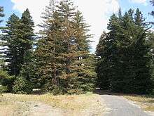
Aside from the city's design, arguably Walter Burley Griffin's longest-living legacy in Canberra is the forest of Redwood trees (both Sequoia sempervirens and Sequoiadendron giganteum) that was planted in 1918 by Walter Burley Griffin and arborist Thomas Charles Weston on Pialligo Avenue.
Footnotes
- ↑ Australian Bureau of Statistics (31 October 2012). "Pialligo (State Suburb)". 2011 Census QuickStats. Retrieved 2 March 2013.
- ↑ "Suburb Name search results". ACT Environment and Sustainable Development. Retrieved 13 February 2014.
- ↑ Henderson G A M and Matveev G, Geology of Canberra, Queanbeyan and Environs 1:50000 1980.